Location & Continent
Continent: North America
Country: United States
Region: Eastern California and southern Nevada, within the Mojave Desert desert belt
Coordinates: 36.24°N, 116.82°W (Badwater Basin area)
Death Valley – Map & Street View
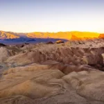
Photos of Death Valley
Gallery: Badwater Basin, Mesquite Flat Sand Dunes, Panamint Range, Salt Polygons (add your media IDs)

Physical Features
Landscape Type: Desert basin with salt flats, alluvial fans, and sand dunes
Park Area: About 3.4 million acres (protected area)
Valley Low Point: Badwater Basin at 282 ft (86 m) below sea level
High Point Nearby: Telescope Peak at 11,049 ft (3,368 m) (a steep vertical contrast)
Salt Flat Extent: Nearly 200 square miles (518 km²) of salt flats in the basin
Climate & Precipitation
Climate Pattern: Hyper-arid at low elevations, shaped by a rain shadow behind mountain ranges
Heat: Summer days can top 120°F (49°C) in the shade, and nights may stay very warm
Rainfall: Average annual precipitation is less than 2 inches (5 cm) in the valley
Notable Record: A surface air temperature of 134°F (56.7°C) at Greenland Ranch (Furnace Creek area) on July 10, 1913 is widely cited
Ecological Features
Biome: Deserts and xeric shrublands with strong elevation-driven zones
Water Logic: Many drainages end in the basin, so water arrives like a brief visitor and leaves as salt on the surface
Habitats: Salt pan, bajada (fan apron), dune fields, spring oases, and high-elevation slopes
Flora & Fauna
Flora: Lowlands often feature creosote bush and salt-tolerant plants; dune areas support mesquite where roots can reach moisture
Fauna: Desert bighorn sheep, small mammals, birds, and reptiles share the basin-and-range stage
Rare Fish: The Salt Creek pupfish survives in salty and temperature-swinging water few fish could tolerate
Geology & Notable Features
Geologic Setting: Part of the Basin and Range, built by crustal extension and fault movement that drops basins and lifts ranges
Salt Flats: The basin floor holds sodium chloride plus calcite, gypsum, and borax from repeated evaporation
Signature Places: Badwater Basin, Mesquite Flat Sand Dunes, and fault-bounded mountain fronts that look like giant stone bookends
Introduction to Death Valley
Death Valley is a desert basin where the land sits so low it feels like the continent has taken a deep breath and held it. That low position matters. It helps trap heat, concentrates salts, and turns the valley floor into a natural laboratory for extreme aridity. Yet the place is not a blank space on the map. It is textured—by dunes that shift like slow waves, by salt that cracks into polygons, and by mountains that rise abruptly into cooler air.
Where Death Valley Fits in the Desert World
Think of Death Valley as a bowl set inside the Mojave Desert system. Desert regions often work like networks: ranges steer winds, basins store heat, and dry washes act as temporary highways for sediment. This valley is a famous node in that network because it combines very low elevation with very dry air, a pairing that helps explain its reputation for intense summer teperature.
Topography That Amplifies Heat
The valley floor sinks to Badwater Basin at 282 ft (86 m) below sea level, while Telescope Peak rises to 11,049 ft (3,368 m) not far away. That is a dramatic vertical span over a relatively short horizontal distance. In practical terms, it creates stacked climates: scorching basins below and cooler air above. The result is a landscape that can feel like multiple deserts layered in one place, each with its own plants and soils by elevation.
| Landform | What You See | What It Suggests |
|---|---|---|
| Salt Pan | Bright flats with polygon cracks | Flood-then-evaporate cycles concentrating minerals |
| Alluvial Fans | Fan-shaped slopes at mountain bases | Sediment delivered in bursts, building a bajada |
| Sand Dunes | Ridges and bowls of windblown sand | Persistent wind patterns storing sand like a bank for dry seasons |
| Faulted Ranges | Steep fronts, tilted blocks, deep canyons | Ongoing extension shaping the Basin and Range architecture |
Salt Flats and the Chemistry of Dryness
The salt flats at Badwater Basin spread across nearly 200 square miles, a huge white sheet that can look smooth from far away. Step closer and the surface becomes a mosaic of salt polygons, like a tiled floor made by nature. These patterns form when thin water films briefly cover the pan, then evaporate, leaving crystals that expand and crack. The salt itself is mostly sodium chloride, with calcite, gypsum, and borax mixed in from repeated cycles.
Sand Dunes That Keep Moving
Mesquite Flat Sand Dunes show another side of desert physics: wind as a sculptor. Here, sand gathers where airflow slows and drops its load, building dunes that shift and reshape. The name matters, too. Mesquite can grow in the dunes because its roots tap hidden moisture, and its presence hints at an unseen layer of water below the surface even in arid terrain.
- Texture: Fine sand that forms sharp ridgelines after windy periods
- Ecology: Dunes provide cover for nocturnal animals and insects adapted to heat
- Botany Clue: Mesquite signals pockets of moisture within the dune system beneath the sand
Why the Air Stays So Dry
Low rainfall in Death Valley is not a simple “no clouds” story. It is geography doing quiet work. Moist air often loses much of its water as it crosses high terrain, leaving less to fall on the basin. That is the rain shadow effect in action across desert ranges. The result is an annual average of less than 2 inches (5 cm) in the valley, a number that helps explain the dominance of salt, stone, and sparse shrubs.
Heat as a Landscape Force
In many deserts, heat is a background condition. In Death Valley, heat becomes an active ingredient. Summer days often exceed 120°F (49°C), and warm nights mean the ground and air do not reset quickly. This persistent warmth speeds evaporation, concentrates minerals, and favors organisms built for water thrift. Even the famous 1913 temperature reading at Greenland Ranch is remembered because it captures the valley’s role as an extreme heat basin on the world stage.
Faults, Ranges, and a Pull-Apart Basin
The valley is part of the Basin and Range province, where the crust has been stretched and broken into blocks along faults. In simple terms, some blocks tilt upward into ranges while others drop into basins, creating the dramatic relief that defines the region. Extension in the Death Valley area began in the Miocene and continues shaping the landscape. The geology reads like a torn book—pages pulled apart—leaving space for basins to fill with sediment and salts over time.
Life Across Elevation Bands
Desert life in Death Valley is organized less by distance and more by height. Low basins support hardy shrubs like creosote, while some springs and wetter pockets host denser growth. Higher slopes can support different plant communities, and the highest elevations may even hold ancient trees. This “vertical zoning” lets the park contain multiple ecological layers, like shelves in a pantry, each stocked with species suited to its temperature and moisture budget.
- Low Valley Floor: Salt-tolerant plants near flats, sparse cover in the driest zones where salt dominates
- Alluvial Fans: Creosote bush and scattered shrubs on stony soils built by sediment pulses
- Dunes: Mesquite and sand-adapted animals in shifting terrain with hidden moisture
- High Country: Cooler conditions and distinct plant communities near peaks above the heat basin
Salt Creek Pupfish and Extreme Water
One of the most striking stories in Death Valley is not written in dunes or rock, but in water only a few inches deep. Salt Creek pupfish live in conditions that can swing wildly in temperature, and the water can become very salty—sometimes even saltier than seawater. Their presence shows how desert ecosystems can be small in area yet huge in meaning, like a single candle lighting a dark room of assumptions.
People, Place Names, and Long Stewardship
Death Valley has long been home to the Timbisha Shoshone, whose knowledge is tied to springs, seasonal movement, and the practical map of the land. Later eras left different marks, including historic borax operations that became part of the region’s story. Today, protection at a large scale keeps the basin’s salt flats, dunes, and faulted ranges intact as a living archive of desert processes and adaptation.
Why Death Valley Matters to Desert Science
Deserts are often described as empty, yet Death Valley is full of information. Its low elevation helps researchers understand how basins trap heat. Its salt pan shows how chemistry and climate interact. Its faults reveal how landscapes form when continents stretch. Even rare wet phases can briefly reintroduce shallow water to parts of the basin, offering a glimpse of how ancient lake systems once behaved. It is an enviroment where the rules of dryness are written in bold letters across the ground.
Sources
NPS – Weather (Death Valley National Park)
NPS – Badwater Basin
NPS – Salt Flats (Badwater Basin)
NPS – Faults and Basin-and-Range Geology
NPS – Fish (Including Salt Creek Pupfish)
NPS – Mesquite Flat Sand Dunes
NOAA NCEI – Earth’s Hottest Temperature (Historical Context)
USGS – Cenozoic Basins in the Death Valley Region (Publication)
UC Davis – CalFish Species Page (Salt Creek Pupfish)
NOAA/NWS – Weather and Climate of Death Valley National Park (PDF)