Desert navigation without GPS is not about guessing where north is and hoping the horizon stays friendly. It is a practical skill built on three things: a map, a compass, and careful reading of the land. In open desert terrain, a small direction error can grow quietly because there are few buildings, signs, trees, or obvious turns to correct it. Good navigation keeps the route visible in the mind before it disappears under sand, stone, glare, or distance.
| Navigation Element | What It Does | Why It Matters in Deserts |
|---|---|---|
| Topographic Map | Shows elevation, slopes, washes, ridges, roads, boundaries, and landforms. | Desert routes often depend on terrain shape rather than marked paths. |
| Compass | Gives a bearing when landmarks are far apart or visibility is reduced. | Flat plains, dunes, and dry lake beds can make direction feel uncertain. |
| Magnetic Declination | Corrects the difference between magnetic north and true north. | Even a small angle error can move a route far off line over distance. |
| Landmarks | Help confirm position by matching real terrain to the map. | Mesas, ridgelines, isolated hills, dry washes, and road junctions are often better than vague sand features. |
| Pace and Time | Estimate distance traveled when no signpost or GPS track is available. | Distance feels shorter or longer depending on heat, sand, slope, and wind. |
| Sun and Stars | Give broad direction clues when used carefully. | They are useful backups, not replacements for map-and-compass navigation. |
Why GPS Alone Is Not Enough in Desert Terrain
GPS is useful, but desert navigation should never depend on one screen. Phones lose battery. Heat can affect devices. Sand and dust enter ports. Offline maps may not show enough land detail. In remote parks and open desert basins, cell service may be weak or absent.
There is also a quieter problem: GPS can hide poor route awareness. A person follows a blue dot, then suddenly has no sense of the surrounding ridges, washes, road angles, or return direction. Without that mental map, the land feels blank.
Desert travel rewards slow observation. Not dramatic observation. Simple observation. Where is the nearest ridge? Which wash did the route cross? Is the ground rising or falling? Is the sun on the same shoulder as before? These details keep a route alive.
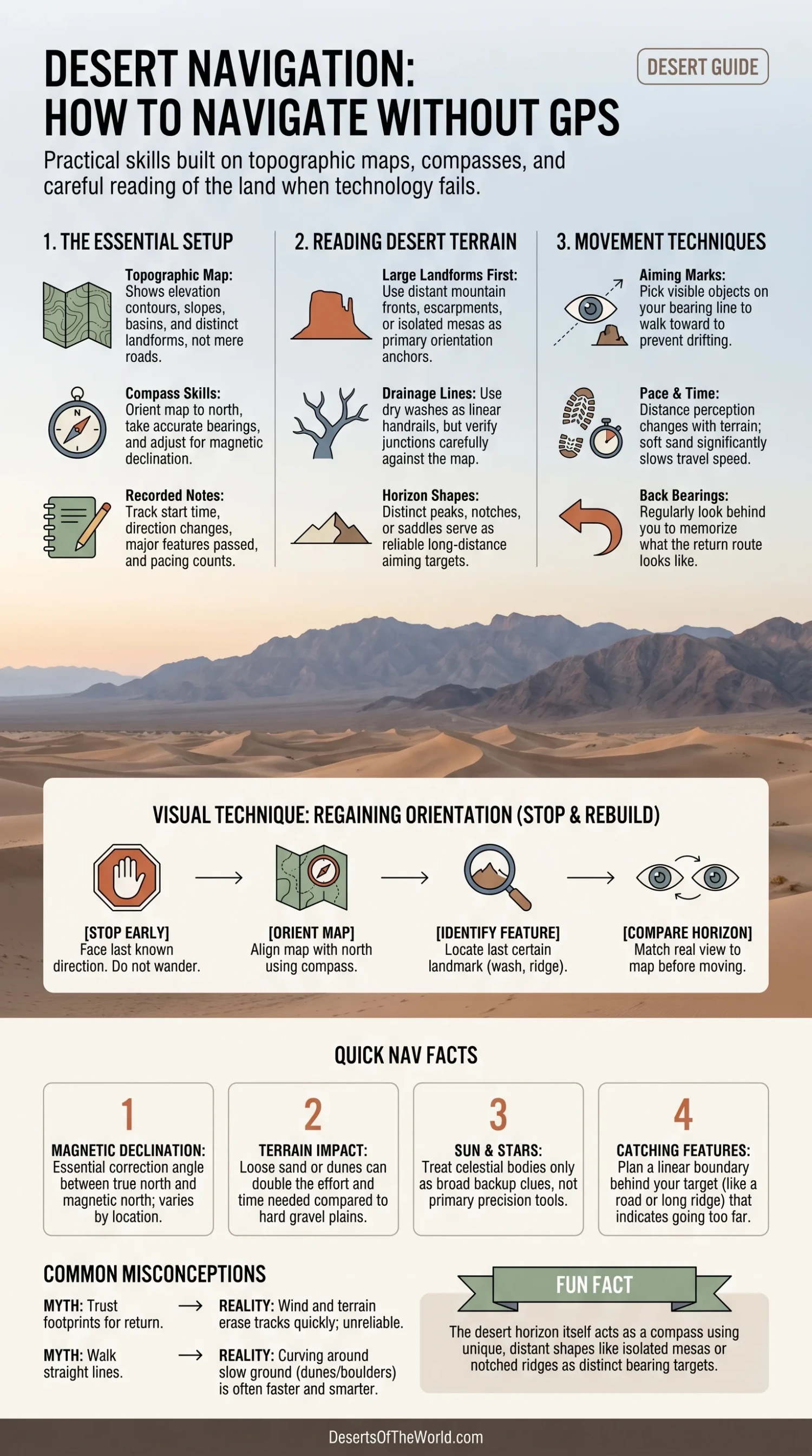
The Basic Desert Navigation Setup
Use a Paper Map That Shows Terrain
A road map may help near highways, but it is rarely enough for desert foot travel or off-road route planning. A topographic map is better because it shows the shape of the land through contour lines. These lines turn a flat sheet of paper into a picture of slopes, basins, saddles, valleys, escarpments, and high points.
Before entering desert terrain, mark:
- The start point and intended return point
- Major ridgelines, hills, mesas, or mountain fronts
- Dry washes, canyons, or drainage lines that can guide direction
- Roads, tracks, fences, visitor routes, or boundary lines where legally accessible
- Possible turn-back points
- Areas that may slow movement, such as soft dunes, salt flats, rocky slopes, or dense desert scrub
A desert map is not just a route sheet. It is the landscape in compressed form.
Carry a Compass You Know How To Use
A simple baseplate compass is enough for most non-technical navigation. The important part is not the brand. It is knowing how to:
- Orient the map to north
- Take a bearing from the map
- Follow that bearing across real ground
- Adjust for magnetic declination
- Check the bearing again before drifting too far
Keep the compass away from metal objects, magnets, phones, vehicle bodies, and some electronic devices when taking a reading. A compass needle is small, but it is not magic. It can be influenced.
Keep Notes on Direction and Distance
A small notebook can be more useful than it looks. Record the time you leave, direction of travel, major terrain features, and any change in route. Short notes work best:
- “Left vehicle at 08:10; ridge east of route.”
- “Crossed wide wash after 25 minutes.”
- “Turned south toward dark mesa.”
- “Return bearing roughly northwest from wash junction.”
These notes reduce confusion later, especially when the return route looks different from the opposite direction. It often does.
How To Read Desert Terrain Without a Screen
Deserts are not empty. They only look that way from far away. Close up, they contain landforms that can guide movement with surprising accuracy.
Use Large Landforms First
Large features are the most dependable. Look for mountain fronts, escarpments, volcanic cones, mesas, buttes, long ridges, dune fields, dry lake beds, or broad valleys. These features help build a mental map before smaller details begin to blur.
In many deserts, mountains frame the basin like the rim of a bowl. If the map shows a mountain range west of the route, keep checking whether that range stays on the correct side. If it shifts behind you or moves to the wrong angle, your direction has changed.
Use Drainage Lines and Dry Washes Carefully
Dry washes are useful because they create natural lines across the desert floor. They may point toward larger valleys, fans, or canyon mouths. They can also twist, divide, and rejoin, so they should be matched to the map rather than followed blindly.
A wash junction is often a strong checkpoint. So is the point where a wash crosses a road, narrows into a canyon, or opens onto an alluvial fan. These are better markers than “the third low dune” or “the pale patch of sand,” because wind and light can change small surface details.
Watch the Shape of the Horizon
The horizon is a desert compass of its own. A flat-topped mesa, double summit, notched ridge, or isolated hill can serve as a bearing target. Once chosen, keep checking it from different angles.
There is a catch. A far landmark may look close in dry air. Clear desert visibility can compress distance in the mind. What seems like a short walk may be much farther, especially over sand, gravel, or broken ground.
How To Navigate With a Compass in the Desert
Set a Bearing Before You Start Moving
Choose a route on the map and measure the bearing. Then adjust for magnetic declination if your compass does not do it for you. Magnetic declination is the angle between true north and magnetic north, and it changes by location and over time.
This detail matters. Over a short walk, a small correction may not seem important. Over a long desert crossing, it can shift the route far from the intended line.
Use Aiming Marks Instead of Staring at the Compass
Do not walk with your eyes fixed on the needle. Take the bearing, then choose a visible object on that line: a rock outcrop, a shrub, a notch in a ridge, a dune shoulder, or a darker patch of ground. Walk to that object. Then repeat.
This method works well because a person naturally drifts when crossing open land. One leg favors the other. Sand pushes each step. Wind and glare pull attention sideways. The compass corrects the mind before the feet wander.
Check Back Bearings
A back bearing points in the opposite direction of travel. It helps confirm the route behind you. If you traveled on a bearing of 70 degrees, the back bearing is 250 degrees. If you traveled on 240 degrees, the back bearing is 60 degrees.
Back bearings are especially useful in dunes, gravel plains, and open basins where the return route looks unfamiliar. Turn around sometimes. Study the land behind you. The way back has its own face.
Measure Progress With Time and Pace
Distance in desert terrain is not only a number. It changes with surface type.
- Hard gravel plain: movement may be steady and easy to estimate.
- Soft sand: each step sinks and shortens the stride.
- Dune slopes: progress slows, even when the map distance looks short.
- Rocky desert pavement: the route may zigzag around rough patches.
- Dry washes: walking may be faster in places, slower where loose stones gather.
Because of this, record time as well as distance. “Forty minutes from the road” may be easier to understand later than a guessed measurement.
Using the Sun Without Turning It Into Guesswork
The sun can help with general direction, but it should be used with care. In broad terms, the sun rises in the east and sets in the west, but the exact point changes with season and latitude. It is higher in the sky around midday and lower in the morning and evening.
For navigation, the sun is best used as a supporting clue. If the sun was on your left shoulder during the outbound route and the time has not changed much, it should not suddenly be in front of you. That kind of mismatch is a warning to stop and recheck the map.
Use Shadows as Direction Clues
A short shadow at midday tells less than a long shadow in early morning or late afternoon. Long shadows can show a rough east-west line if observed over time. Still, a shadow method should not replace the compass. It is too easy to overread it when tired or rushed.
Understand Desert Light
Desert light can flatten landforms. In harsh overhead light, washes and slopes may almost disappear. Near sunrise or sunset, the same ground can look sharply textured. This is helpful for reading relief, but it can also make a familiar area look new.
Glare, pale sand, salt flats, and light-colored rock can make distance feel strange. The land may seem closer, cleaner, and simpler than it really is.
Using Stars When the Sky Is Clear
Night navigation has a long history, and desert skies can be clear enough for strong celestial clues. Even then, star navigation should be treated as broad orientation unless the person has practiced it.
Polaris in the Northern Hemisphere
In the Northern Hemisphere, Polaris sits close to true north. It does not move across the sky in the same obvious arc as many other stars, so it has long been used as a north reference. If Polaris is visible and correctly identified, it can help confirm direction.
Southern Cross in the Southern Hemisphere
In parts of the Southern Hemisphere, the Southern Cross can help estimate the direction of south. It takes practice because the constellation does not point as simply as a road sign. Nearby bright stars can also cause confusion for beginners.
The rule is simple: stars are useful when known, not when guessed.
Dunes Are Helpful, But Easy To Misread
Sand dunes can give navigation clues, especially where wind patterns are steady. Barchan dunes, for example, often form where sand supply is limited and wind comes mainly from one direction. Their horns usually extend downwind, while the steeper slip face also sits on the downwind side.
That sounds simple. In real desert terrain, it is not always simple.
Wind can shift by season, storm, valley shape, or local topography. Star dunes may form where winds arrive from more than one direction. Vegetation can anchor parabolic dunes. Vehicle tracks and footmarks may vanish quickly. A dune field that looked orderly from a distance can feel repetitive from inside.
Better Dune Clues
- Use the edge of a dune field as a boundary, not the center of it as a route line.
- Use mountain ranges or rocky outcrops beyond the dunes as aiming marks.
- Do not trust footprints on loose sand as the main return method.
- Notice whether dunes sit against a barrier, basin edge, or mountain front.
- Match dune fields to the map by shape and position, not by individual dune forms.
Route Choice: The Desert Is Not a Blank Space
The shortest line on a map is often not the best desert route. A straight bearing across soft dunes, salt crust, boulder fields, or thorny scrub can cost far more time than a slightly longer line along firmer ground.
Use Handrails
A handrail is a long feature that helps guide movement. In desert navigation, useful handrails include:
- A mountain front
- A dry wash
- A road or legal track
- A fence line where access is allowed
- A ridge crest
- The edge of a lava flow, dune field, or dry lake bed
- A canyon wall or escarpment
Following a handrail reduces the need for constant compass work. It also gives the mind something solid to hold.
Use Attack Points
An attack point is an easy-to-find feature near a harder-to-find destination. Instead of trying to walk directly to a small spring, survey marker, trail junction, or viewpoint, aim first for a larger feature nearby. That might be a wash bend, road crossing, saddle, or isolated hill. From there, navigate the final short distance.
This method is useful in deserts because small targets can disappear behind low relief or heat shimmer.
Use Catching Features
A catching feature tells you that you have gone too far. It might be a road, canyon, ridge, dry lake edge, or large wash. Plan these before moving. For example: “If the route reaches the wide wash, the target is already behind us.”
Simple, but very effective.
Landforms That Help Desert Navigation
| Landform | How It Looks | Navigation Value |
|---|---|---|
| Mesa | Flat-topped high ground with steep sides. | Strong landmark visible from long distance. |
| Butte | Smaller isolated hill with steep sides. | Good aiming mark or checkpoint. |
| Dry Wash | Shallow or deep drainage channel, often sandy or stony. | Useful handrail, but may branch often. |
| Alluvial Fan | Fan-shaped spread of sediment below a slope or canyon mouth. | Helps identify mountain-front drainage systems. |
| Dune Field | Area of repeated sand ridges, crescents, or mounds. | Useful as a broad area marker; poor for exact position inside the field. |
| Sabkha or Salt Flat | Flat, pale, often crusted basin surface. | Visible on maps and satellite imagery; surface condition can vary. |
| Desert Pavement | Hard ground covered with closely packed stones. | Often easier for steady movement than soft sand. |
| Escarpment | Long steep slope or cliff-like edge. | Strong boundary and horizon feature. |
Regional Desert Differences That Change Navigation
Not all deserts navigate the same way. A method that works well on a rocky plateau may feel weak in a pale dune sea. The best navigators adapt to the land in front of them.
| Desert Setting | Common Navigation Challenge | Useful Land Clues |
|---|---|---|
| Sahara Sand Seas | Large dune fields can repeat patterns and hide low features. | Dune-field edges, rocky plateaus, escarpments, wells where mapped, and distant massifs. |
| Namib Desert | Tall dunes and coastal fog can reduce simple visual orientation. | Coastline direction, dune corridors, gravel plains, inselbergs, and river valleys. |
| Arabian Desert | Sand seas, gravel plains, and broad basins may alternate over long distances. | Escarpments, wadis, sabkha margins, dune trends, and road corridors. |
| Mojave Desert | Basin-and-range terrain can make routes look direct but slow across rough ground. | Mountain ranges, alluvial fans, washes, volcanic hills, and old road alignments. |
| Atacama Desert | Dry basins and mineral flats may create strong glare and few water-shaped cues. | Salt flat margins, volcanic cones, ridgelines, mining roads where public access allows, and basin edges. |
| Gobi Desert | Open steppe-desert and gravel plains can have long horizons with subtle relief. | Low ridges, dry channels, mountain fronts, tracks, and isolated high points. |
| Australian Interior Deserts | Long sandy ridges, scrub, and remote tracks can make progress slower than expected. | Track junctions, dune ridge trends, salt lakes, drainage lines, and low ranges. |
What To Do If the Route Becomes Unclear
The most useful move is also the least dramatic: stop early. Do not keep walking just to feel productive. In desert navigation, extra movement can turn a small uncertainty into a large search area.
Stop and Rebuild the Map in Your Head
- Face the last known direction of travel.
- Mark the current spot with a harmless visible marker if appropriate.
- Check the compass and orient the map.
- Look for the last certain feature: road, wash, ridge, hill, junction, or dune-field edge.
- Compare the horizon to the map before moving again.
If traveling with others, keep the group together. Separation makes navigation harder and creates more uncertainty.
Return To the Last Certain Point
If the last certain point is close and the route back is clear, return to it. This might be a road crossing, wash junction, saddle, campsite, vehicle, or marked trail. From there, restart the route with a fresh bearing.
A person who admits “this is the last point I truly know” is not lost in the same way as someone who keeps inventing certainty.
Use the Vehicle as a Fixed Reference
When desert travel begins from a vehicle, the vehicle is often the strongest fixed point. Note the bearing from the vehicle to the first landmark, and the back bearing from that landmark to the vehicle. If the vehicle is visible from high ground, use it as a base reference rather than wandering in wider circles.
If a vehicle cannot move because of mechanical trouble or terrain, staying with it is often safer than walking away without a clear plan. A vehicle is easier to see than a person.
Common Desert Navigation Mistakes
Trusting Footprints Too Much
Footprints can vanish under wind, hard ground, rock, or other tracks. In white sand, pale gypsum, or dry wash gravel, they may be hard to read even after a short time.
Using Only Near Landmarks
A nearby bush or small rock pile may seem clear now and disappear later among hundreds of similar shapes. Use large landmarks first, then smaller features for close confirmation.
Ignoring Magnetic Declination
A compass points to magnetic north, not automatically to true north. Maps usually use true north or grid north. The difference must be understood before following a long bearing.
Walking a Straight Line Across Slow Ground
Soft sand, steep dune faces, boulder patches, and broken crust can turn a short line into a slow route. Better navigation often means choosing a smarter curve.
Starting Without a Return Plan
The outbound route is only half the navigation problem. Before leaving, know what the return route should look like, which bearing brings you back, and what large feature sits beyond the start point.
Desert Navigation Skills Worth Practicing Before Remote Travel
- Orienting a map with a compass
- Taking and following a bearing
- Estimating distance by pace and time
- Matching contour lines to hills, washes, and ridges
- Choosing handrails, attack points, and catching features
- Reading the horizon from both outbound and return directions
- Recognizing broad dune types without depending on them too heavily
- Using the sun and stars as backup direction clues
Practice should begin in easy terrain with clear boundaries. A small desert park trail, a marked open area, or a safe local landscape is enough. Skill grows by matching map, compass, and real ground again and again.
Frequently Asked Questions
Can You Navigate in a Desert Without GPS?
Yes. Desert navigation without GPS is possible with a topographic map, compass, terrain awareness, and a planned route. The most dependable method combines map reading, bearings, large landmarks, distance checks, and return bearings.
Is the Sun Enough To Navigate in the Desert?
The sun can help with broad direction, but it is not enough for accurate desert navigation. Its position changes by time of day, season, and latitude. Use it as a clue, not as the main method.
Are Dunes Reliable for Direction?
Dunes can offer clues about wind direction, but they are not fully reliable for route finding. Wind patterns can shift, dune types vary, and repeating sand forms can confuse distance and position.
What Is the Most Important Tool for Desert Navigation?
A map and compass together are the main tools. A compass without a map gives direction but not position. A map without a compass may be hard to orient in open terrain. Used together, they give both structure and direction.
Why Do People Get Turned Around in Deserts?
Deserts often have wide horizons, repeated landforms, few signs, glare, and long distances between obvious features. A small change in direction can go unnoticed until the original route is no longer clear.
Should You Follow a Wash in the Desert?
A wash can be a useful handrail, but it should be checked against the map. Washes may split, curve, narrow, or lead away from the intended route. They are best used with compass checks and known exit points.
Sources
- National Park Service – White Sands Hiking Safety Tips (desert navigation cautions, landmarks, compass use, and GPS limits in dunes)
- National Park Service – Arches National Park Safety (maps, compass backup, route planning, and desert travel safety)
- U.S. Geological Survey – Topographic Mapping (topographic map purpose, contour lines, natural features, and landform reading)
- U.S. Geological Survey – topoView Help (how contour lines show land shape, elevation, slope, and map symbols)
- NOAA National Centers for Environmental Information – Magnetic Declination (difference between magnetic north and true north, and why declination changes by place and time)
- Royal Museums Greenwich – True North and Magnetic North (north references, compass history, and Polaris as a traditional direction aid)
- U.S. Geological Survey – Geology of Great Sand Dunes National Park (dune formation, wind movement, slip faces, barchan dunes, and dune behavior)