Location & Continent
Continent: North America
Country: Greenland (Kalaallit Nunaat) – an autonomous territory within the Kingdom of Denmark
Coordinates (central ice sheet): 72°N, 40°W
Although most visitors imagine Greenland as a land of endless ice, much of its interior behaves like a vast polar desert, where air is so cold and dry that snowfall is extremely limited and moisture almost never reaches the ground.
Greenland – Map & Overview
You can explore the island’s ice sheet, long fjords and narrow coastal strip directly on the map:
Click to load the interactive map
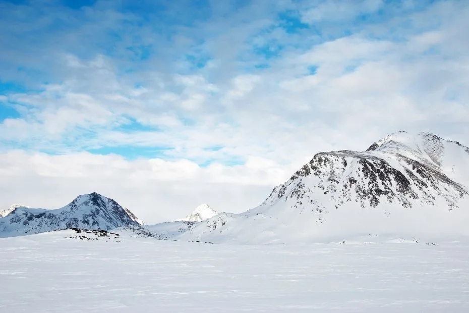
Photos of Greenland’s Polar Desert
The contrast between bright white ice plains, dark rocky nunataks and deep blue meltwater streams makes Greenland’s polar desert landscapes visually striking.
Physical Features
Area of Greenland: about 2.16 million km², making it the world’s largest island. Around 75–80% of this surface is covered by the central ice sheet, with only a narrow rim of ice-free land along the coasts.
Greenland Ice Sheet Area: roughly 1.7 million km², holding about 2.9 million km³ of ice, a frozen reservoir that stores enough water to raise global sea level by several meters if fully melted.
Elevation Range: from sea level fjords to high plateau areas over 3,000 m, with the thickest ice near the centre of the island.
Climate & Precipitation
In the interior of Greenland, the air is extremly cold and very dry. At Summit Station, high on the central ice sheet, average yearly temperatures sit near -22 °C and annual precipitation is only about 10 mm, which is drier than many warm-climate deserts.
Coastal towns such as Nuuk have a milder tundra climate with cool summers and long, cold winters, and they receive much more moisture, often a few hundred millimetres of snow and rain per year.
The combination of low precipitation, sub-freezing temperatures and persistent winds creates the classic conditions of a polar desert across much of the ice sheet and in far-northern Greenland.
Ecological Features
Beyond the ice, Greenland’s ice-free land belongs mainly to two ecoregions: the Kalaallit Nunaat Arctic Steppe in the south and the High Arctic Tundra in the north.
In the highest and driest zones, conditions shift from tundra to polar desert, where bare stone, gravel and thin soils dominate and vegetation cover is only patchy.
Flora & Fauna
In Greenland’s polar desert belts, hardy lichens, mosses and a few cushion plants cling to cracks in the rock, taking advantage of short bursts of summer meltwater and weak sunlight.
Wildlife is concentrated along coasts and ice-free valleys, where muskoxen, Arctic foxes, hares, seabirds and occasionally polar bears roam between snow patches, cliffs and open tundra.
Geology & Notable Features
Greenland sits atop very old Precambrian shield rocks, carved by ice into long fjords, rounded hills and steep coastal mountains.
Beneath the ice sheet lie hidden canyons, valleys and ancient lake basins, sculpted before the ice formed and later buried under kilometres of glacial ice.
Greenland as a Frozen Desert
At first glance, Greenland does not look like a desert at all. Everything seems buried under snow and ice. Yet, when scientists look at the climate, they see a classic desert pattern: very little precipitation, dry air and long stretches with almost no fresh snowfall in the interior. Large parts of Greenland therefore qualify as a polar desert, a cousin of the hot deserts found in Africa or Asia, shaped not by heat but by serious cold.
In this environment, ice takes the role that sand plays in lower-latitude deserts: it blankets the landscape, moves slowly under its own weight, and is carved by wind into sharp ridges and smooth plains, while life hangs on in the margins where conditions ease just a little.
What Makes a Polar Desert?
A polar desert is defined less by the presence of sand and more by very low precipitation, cold temperatures and limited plant cover. In the high Arctic, including parts of northern Greenland, yearly precipitation can be as low as 25–200 mm, mostly falling as light snow or fog that may sublimate back into the air before it ever melts.
Because water is locked up as ice, the landscape stays desiccated despite the frozen surface. Soils are thin, winds are strong, and only small patches of tundra vegetation can take root in sheltered areas. To many plants and animals, this environment feels like an endless dry season that never quite ends.
Regions of Greenland’s Polar Desert
The most desert-like parts of Greenland are found in three broad zones: the high central ice sheet, the far north around Peary Land and the vast Northeast Greenland National Park. Each area shows a different face of the Arctic desert.
- Central Ice Sheet: a high, gently domed expanse of ice and snow, where temperatures stay far below freezing and annual precipitation is extremely low, especially around research sites such as Summit Station.
- Northern Greenland: includes ice-free Arctic desert valleys and rocky slopes near fjords such as Olrik, where vegetation is sparse and winds scour the ground.
- Northeast Greenland National Park: the world’s largest national park, mixing polar desert plateaus, glaciers, nunataks and remote fjords where only a few research stations and seasonal camps exist.
Climate and Weather in the Frozen Interior
Over the central ice sheet, winter brings long periods of polar night and temperatures that may plunge below -40 °C. Winds sweep across the surface, moving fine snow like desert dust and forming sharp ridges called sastrugi, the icy equivalent of sand dunes.
Summer is short and still chilly. Air temperatures rise a bit above freezing, the sun circles low in the sky, and meltwater streams appear briefly on the ice. Even then, most of the year’s precipitation arrives as light, dry snow, keeping the interior a remarkably arid cold desert.
Life in Greenland’s Polar Desert
Life survives by staying low, small and patient. On bare rock surfaces, tiny lichens and cold-adapted microbes grow so slowly that a patch the size of a hand may be decades old. In shallow soils, dwarf willows and saxifrages hug the ground, forming cushions that trap heat and moisture like miniature green islands in a sea of stone.
Animals move widely across this harsh mosaic. Muskoxen graze on sparse grasses and sedges, their thick coats shielding them from wind. Arctic foxes and stoats hunt for lemmings or scavenge along the coast. In summer, cliffs and tundra host nesting seabirds, geese and waders that use the brief warm season to raise their young before returning to the wider Arctic Ocean.
People Living on the Edge of the Desert
Most of Greenland’s people live in small towns and settlements scattered along the ice-free coastal fringe, especially in the southwest near Nuuk and in the west-central fjords. Here the climate is still cold, but more forgiving than the central ice sheet, and the ocean provides food through fishing and hunting.
Indigenous Inuit communities developed deep knowledge of the Arctic environment, learning to travel safely near glaciers, read the weather, and make full use of resources from the sea and tundra. Modern Greenland mixes this long tradition with newer industries such as research and carefully managed tourism, while the uninhabited polar desert inland remains largely the realm of scientists and a few skilled expedition teams.
Hidden Landscapes Beneath the Ice
Radar studies show that under the Greenland Ice Sheet lies a complex landscape of mountains, valleys and lake basins. Scientists have discovered a subglacial canyon hundreds of kilometres long and evidence of ancient lakes that once occupied now-buried depressions, carved before major glaciation and later sealed under thick ice.
These hidden features influence how meltwater flows beneath the ice, guiding it towards outlet glaciers and fjords. Understanding this unseen topography is essential for predicting how the ice sheet will respond to ongoing climate change and how fast ice can reach the ocean.
Greenland’s Polar Desert and Global Climate
Although rainfall and snowfall are still low over much of the ice sheet, warming air and ocean waters have increased surface melting and the flow of outlet glaciers. In recent decades, the Greenland Ice Sheet has generally been losing more mass than it gains from snow, with some years showing large net losses, and other years – such as 2024 – showing smaller but still noticeable shrinkage.
If the ice sheet were ever to melt completely, global sea level could rise by more than 6 metres, reshaping coasts around the world.In this sense, Greenland’s remote polar desert is closely linked to everyday life far away: the stability of its frozen “desert of ice” helps moderate sea level, ocean circulation and even weather patterns across the Northern Hemisphere.
Visiting Greenland’s Desert of Ice
Travel to Greenland usually focuses on the coasts, where visitors can join boat trips among icebergs, hike along tundra valleys or fly by helicopter over the ice sheet margin. Any journey toward the interior polar desert demands careful planning with local guides, solid safety gear and respect for rapidly changing Arctic weather.
For many people, the most rewarding view of this frozen desert comes from viewpoints near towns like Ilulissat, Kangerlussuaq or Nuuk, where you can stand on bare rock and look inland to the smooth white dome of the ice sheet and outward to dark, glacier-cut fjords at the same time.
References
- National Snow and Ice Data Center – Ice Sheet Quick Facts (Greenland)
- NOAA Arctic Report Card – Greenland Ice Sheet
- World Bank Climate Change Knowledge Portal – Greenland Climate Profile
- Visit Greenland – Weather and Climate in Greenland
- European Environment Agency – Polar Desert Habitat Description
- NASA Astrobiology – Life in the Extreme: Polar Deserts