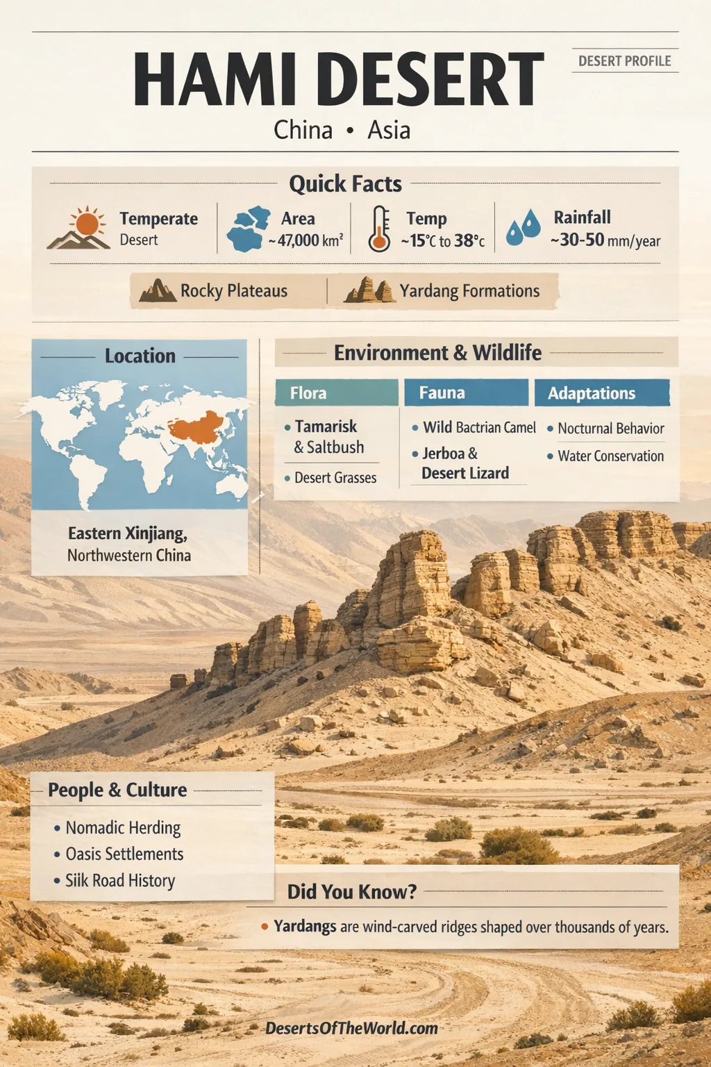
Location & Continent
Continent: Asia
Region: Eastern Xinjiang, northwestern China
Desert System: Gobi Desert (often described as the Hami sector)
Natural Boundaries: Tian Shan to the north, Nan Shan to the south, and a westward link toward the Desert of Lop
Central Coordinates: 42.0°N, 93.0°E (approximate center for mapping)
Local Names: Hāmì Shāmò (Chinese), Qumul Qumluqi (Uyghur), also called the Desert of Hami
Hami Desert – Map & Street View
Physical Features
Landscape Type: A gravel-and-clay desert where desert pavement, low plateaus, and wind-carved ridges dominate more than classic “sand seas”
Representative Width: Around 320 km north-to-south in widely described cross-sections of the region, with broad plains stepping down toward oasis basins
Typical Elevations: Uplands commonly near 1,500 m, with local highs around 1,700 m on interior plateaus; oasis floors can sit much lower, near 850 m
Signature Landforms: Yardangs (also spelled jardangs), gravel plains, dry basins, and low, worn mountain chains like the Beishan area
Climate & Precipitation
Climate Type: Temperate continental desert with sharp day–night swings and long, bright skies
Precipitation: Often around 20–50 mm per year across the broader Hami basin area, with some pockets receiving even less; rainfall, when it comes, is usually brief
Temperature Pattern: Hot summers, cold winters, and a big daily range that can feel like a two-season day
Wind: Frequent west and northwest winds that can lift dust and sand, polishing the land like a slow, endless sandblaster
Ecological Features
Ecozone: Central Asian aridlands where life clusters around subtle moisture cues
Biome: Deserts and xeric shrublands, with patches of desert steppe near gentler slopes
Productivity Pattern: Low overall, yet surprisingly responsive after rare wet spells, when dormant seeds can wake up fast
Flora & Fauna
Typical Flora: Tamarisk, salt-tolerant shrubs, hardy desert grasses, and deep-rooted bushes that anchor loose sediments
Typical Fauna: Small mammals, reptiles, and birds that rely on shade, burrows, and timing; many are most active at dawn or night
Adaptation Theme: Efficiency—saving water, avoiding heat, and making the most of short windows of mild weather
Geology & Notable Features
Rock Story: A mix of ancient hard rocks and younger sediments, sculpted by wind, temperature stress, and occasional runoff
Notable Features: Wind-cut ridges, clay “walls,” gravel armor, and basin edges that funnel airflow into fast-moving gust corridors
Hami Desert Profile
The Hami Desert sits in a dramatic corridor of dryness, where mountains frame the horizon and the land in between becomes a wide, quiet expanse. It is often described as a part of the Gobi Desert, shaped by a classic interior-Asia recipe: distance from oceans, strong winds, and mountain ranges that intercept moisture before it can reach the basin.
This is not a desert of endless dunes alone. The Hami landscape is more like a stony ocean—gravel sheets, hard-baked clay, and scattered ridges that rise and fall in slow waves. In many places, the ground is protected by desert pavement, a natural “armor” of stones left behind after wind removes finer grains, grain by grain, year after year.
Where the Desert Sits in the Asian Dry Belt
In map terms, the Hami Desert occupies the space between the Tian Shan to the north and the Nan Shan to the south. That positioning matters. Mountain walls help create a rain-shadow effect, meaning much of the available moisture falls on higher slopes instead of reaching the lowlands.
To the west, the desert’s arid character connects toward the Desert of Lop, forming a broader chain of dry basins and wind-shaped surfaces. Think of it as a linked set of landscapes: basin floors, piedmont fans, and gravel plains that blend into one another without a neat border line.
The region is also tied to the wider Gobi system, where many “deserts” are not pure sand, but a mosaic of regs (gravel plains), clay flats, and occasional dune patches. That mix is exactly what gives the Hami area its distinct texture and color.
Landforms That Define the Hami Desert
One of the most striking features is the presence of yardangs—long, wind-carved ridges cut into softer sediments. From above, they can resemble a frozen fleet of ships, all pointed in the same direction. On the ground, yardangs feel like natural corridors, with narrow passages and abrupt clay “walls.”
These forms are created by a partnership of forces: wind abrasion, deflation (wind removing loose grains), and the stress of big temperature swings. Over time, the softer material is worn down first, leaving behind tougher ribs and ridges. The result is a landscape that looks carved rather than piled.
Broad interior plateaus also appear in regional descriptions, with elevations around 1,500 m and local highs near 1,700 m. Nearby, the land steps down toward oasis basins, where the difference in height influences airflow, drainage, and where fine sediments can gather.
Along basin edges, alluvial fans spread out like open handprints—sediment delivered by short-lived streams coming off mountain slopes. When water flow fades, the fan remains as a gently sloping stage where wind can later pick up the smallest particles and carry them away.
Climate Rhythm: Dry Air, Bright Skies, Big Swings
The Hami Desert climate is shaped by dryness and contrast. Annual rainfall is generally very low across the Hami basin area—often tens of millimeters rather than hundreds. Rain tends to arrive in short, modest events, then disappear again, leaving long stretches of clear weather.
Temperature behavior is just as important as rainfall. Summers can be intensely hot, while winters can be sharply cold. The daily range is often the headline: warm sunlight by day, fast cooling after sunset. That rapid shift affects everything from rock breakdown to animal behavior. It also means the same place can feel gentle at dawn and harsh by midday.
Wind is a major sculptor here. Prevailing airflow from the west and northwest can move dust, polish stones, and push sand into low drifts at valley outlets. In plain terms, wind acts like a patient tool—slow, steady, and unstoppable. Over long periods, it can shape a landscape as surely as water shapes a river valley.
In colder seasons, winds from other directions can arrive with chillier air. That seasonal change can clear the atmosphere, reduce haze, and briefly alter surface conditions. A desert is never static; it simply changes at a quieter volume.
Water in a Place That Rarely Sees Rain
In the Hami Desert, surface water is not a constant presence. It behaves more like a visitor—appearing along channels after mountain-fed runoff, then retreating. Some named streams and seasonal drainages are described in older geographic accounts, including flows that end in shallow basins or lakes. These basins can become saline flats when water evaporates and leaves minerals behind.
Groundwater matters, especially near oasis areas. Where subsurface water is reachable, vegetation becomes denser and more diverse. Oases are not random green dots; they are the surface expression of hidden water pathways, guided by geology and elevation.
Even when water is scarce, its traces shape the terrain. Dry channels mark old flow lines. Fan deposits record past pulses. Fine silts on basin floors can later become the raw material for dust when winds strengthen. In this way, water writes the first draft and wind edits it.
Plants That Live on Patience
Vegetation in the Hami region is sparse, yet it is not absent. Plants that survive here specialize in one skill: endurance. Many shrubs tolerate salty soils and long droughts, while others send roots deep or spread wide, chasing moisture that may only appear occasionally.
Tamarisk is often mentioned among desert shrubs in this part of Central Asia. It can grow where soils are salty and water is inconsistent. Some shrubs also form small mounds at their base, as wind removes surrounding sediment and the plant’s root zone stays slightly raised—an effect that makes the plant look perched on a tiny island.
After rare wet periods, short-lived plants can appear quickly, adding a thin, temporary layer of color to the surface. It is a brief show, but meaningful: seeds may wait for years, then respond in days. That stop-start life cycle is a hallmark of aridland ecology.
Animals and Daily Timing
Desert animals here often avoid the harshest hours. Many are most active at night, early morning, or late afternoon, when the temprature is less extreme. Small mammals use burrows as climate shelters, keeping body heat and water loss under control.
Birds are part of the desert story as well, especially in areas where shrubs or oasis edges provide resting and feeding spots. In broad, open basins, sightings may be few, yet the sky still connects habitats—animals can travel across what looks empty, using scattered resources like stepping stones.
Reptiles and insects also play a quiet role, moving through the warm season with strategies that match the ground’s rhythm: warming up fast in sun, cooling down in shade, and using microhabitats created by stones, shrubs, and shallow depressions.
Geology Under the Dust
Beneath the desert’s surface is a layered record of rock types and tectonic history. Regional descriptions include hard crystalline rocks in uplands—granites and metamorphic rocks—alongside broad spreads of sediments in basins. Over time, physical weathering breaks rock into fragments, then wind and rare runoff rearrange those fragments across the landscape.
A key process here is insolation weathering, where intense sunlight heats rock surfaces by day and rapid cooling follows at night. This repeated expansion and contraction can weaken rock, creating fresh fragments that join the gravel cover. With steady wind, finer grains are winnowed away, leaving the surface increasingly stone-rich and stable.
Fine material does not vanish; it migrates. Dust can travel far and later settle as silt-rich deposits downwind. Over long timescales, this movement links distant regions through the atmosphere, turning the desert into a quiet engine of sediment transport.
Hami Oasis Edges and the Desert Gradient
Near the Hami oasis, the desert changes character. There is a gradient from cultivated green zones to semi-arid margins, then into more open Gobi-like surfaces. That transition is not sudden. It can happen over a few kilometers, with vegetation thinning, soils becoming saltier, and surface textures shifting from fine sediments to gravel armor.
This gradient helps explain why the Hami Desert is often described as a mixed desert rather than a single uniform landform. Basin floors, fan slopes, and wind-cut ridges each create different living conditions. Even small differences—slightly lower ground, a patch of finer soil, a bit of shade—can matter.
In the broader eastern Xinjiang setting, deserts connect and overlap. The Hami sector links naturally with other arid landscapes nearby, forming a chain where each segment has its own signature: some more gravelly, some more sandy, some more sculpted into ridges and corridors.
Key Terms Seen in the Hami Desert Landscape
- Yardang: Wind-carved ridge cut into soft sediment, often aligned with prevailing winds
- Desert Pavement: A protective stone layer formed as wind removes fine particles
- Alluvial Fan: A sediment “fan” built by runoff from mountains, later reshaped by wind
- Playa: A dry basin floor that can become salty and dusty after evaporation
- Rain Shadow: A drying effect created when mountains force moisture to fall before it reaches the basin
Hami Desert Data Table
| Category | Details |
|---|---|
| Desert Type | Temperate Gobi-style desert with gravel plains and wind-cut forms |
| Core Setting | Between Tian Shan (north) and Nan Shan (south), linking westward toward the Desert of Lop |
| Notable Landforms | Yardangs, desert pavement, alluvial fans, dry basins |
| Rainfall Range | Often 20–50 mm/year across the broader basin; highly variable by location |
| Ecology Pattern | Sparse shrubs and desert grasses; life clusters near moisture pathways and oasis edges |
References
NASA Earth Observatory – Gobi Desert Dust Storm
NASA Earth Observatory – A Wall of Dust in the Tarim Basin
Chinese Academy of Forestry – Desertification Combating (Kumtagh Research Mentions)
Scientific Reports – Turpan–Hami Basin Climate and Water Scarcity (PDF)
ScienceDirect – Turpan–Hami Basin Precipitation and Glacier-Linked Runoff