Location & Continent
Continent: South America
Countries: Mainly Colombia (La Guajira Department), with a smaller portion in Venezuela (Zulia State)
Region: La Guajira Peninsula, the northernmost tip of South America
Approximate Coordinates (center of the desert): 12°04′18″N, 71°35′52″W
The La Guajira Desert spreads over much of the La Guajira Peninsula along Colombia’s Caribbean coast, just east of the Sierra Nevada de Santa Marta and west of the Gulf of Venezuela. Dry trade winds from the Caribbean sweep over the flat peninsula and drop almost no rain, turning this corner of the tropics into a striking coastal desert.
La Guajira Desert – Map & Street View
Click to load the interactive map
Click to load the interactive map
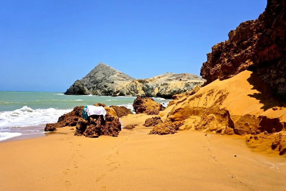
Photos of the La Guajira Desert
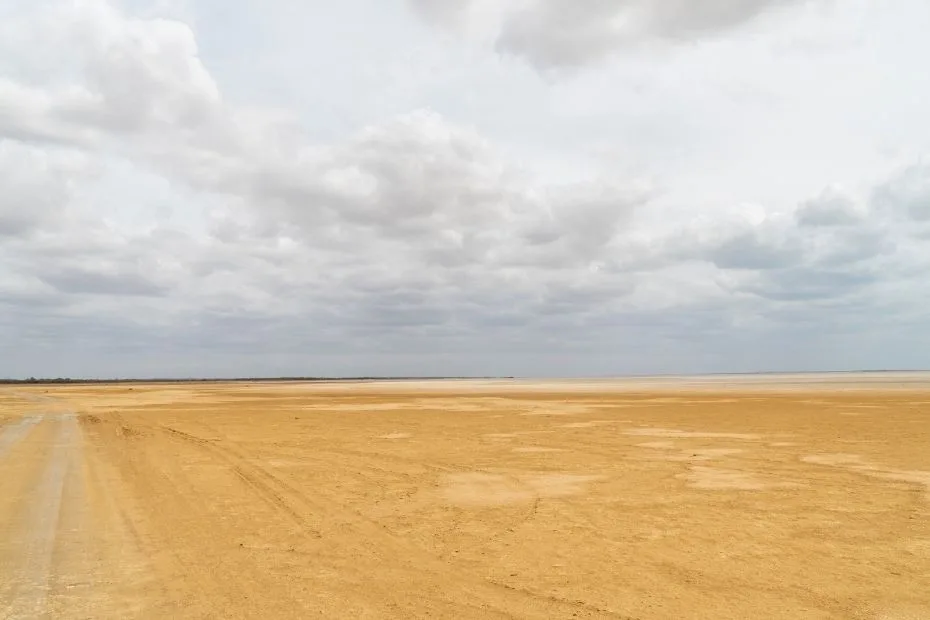
- Golden coastal dunes rolling directly into the Caribbean Sea at Punta Gallinas.
- Wind-sculpted cliffs and turquoise bays near Cabo de la Vela.
- Rust-red, scrub-covered plains dotted with cacti and thorny shrubs.
- Lush green hills and cloud forests of Macuira National Natural Park, rising unexpectedly from the desert floor.
Physical Features
| Feature | Details |
|---|---|
| Approximate Desert Area | Occupies much of the 25,000 km² La Guajira Peninsula, especially the central and northern (Alta Guajira) zone |
| Elevation Range | From sea level along the Caribbean coast up to ~450 m in Macuira’s foothills; nearby Macuira peaks reach ~864 m |
| Landscape Types | Coastal dunes, marine terraces, gravel plains, rocky headlands, inland mesas, seasonal salt flats and dry streambeds. |
| Notable Sites | Punta Gallinas (northernmost point of South America), Cabo de la Vela, Macuira National Natural Park, Los Flamencos Sanctuary. |
Geographically, the desert is often divided into Alta Guajira (the most arid, dune-dominated north), Media Guajira (semi-arid with more vegetation and red sands), and Baja Guajira, closer to the mountain ranges and therefore slightly wetter with more rivers and seasonal streams.

Climate & Precipitation
Climate Type: Hot, arid to semi-arid coastal desert
Average Temperature: Around 27–29 °C (81–84 °F) year-round
Annual Rainfall: Often below 300 mm in the driest parts of the peninsula
Winds: Persistent northeast trade winds from the Caribbean Sea
| Season | Typical Conditions | Notes |
|---|---|---|
| Dry season (Dec–Apr) | Very low rainfall, strong sun, frequent dusty winds. | The desert looks especially stark; water sources are under pressure. |
| Rainier months (May–Nov) | Short, irregular showers; humidity rises slightly. | Some plants green up and ephemeral pools form, especially near Macuira. |
Why is a place so close to the warm Caribbean so dry? Moist trade winds blow inland but meet almost no mountains on the peninsula, so they hardly drop any rain until they hit the distant Sierra Nevada de Santa Marta, where rainfall exceeds 3,000 mm a year. La Guajira ends up in the shadow of that rain, with many areas receiving barely a tenth of that amount.
Ecological Features & Ecoregions
The La Guajira Desert forms part of a wider tropical dry forest and xeric scrub belt along northern South America. Most of the landscape is covered not by bare sand, but by hardy shrubs, thorn forests, columnar cacti and salt-tolerant coastal vegetation.
- Xeric scrublands: Dominated by low thorny bushes, Prosopis species, agaves and cacti.
- Coastal lagoons and mangroves: At places like Los Flamencos Sanctuary, shallow saline lagoons support flamingos and other waterbirds.
- Mountain oasis ecosystems: In Macuira National Natural Park, cloud forests, springs and dune-forests form an island of moisture in the middle of the desert.
This mix of arid plains, wetlands and green hills creates a mosaic of habitats that holds much more life than first meets the eye.
Flora & Fauna of La Guajira Desert
Adapted Desert Flora
Plants in La Guajira have evolved to squeeze the most out of every drop of water. Common groups include:
- Cacti and succulents: Tall columnar cacti, prickly pears and agaves store water in their tissues and reduce leaf area to cut evaporation.
- Thorny shrubs and small trees: Deep roots tap underground moisture; tiny leaves fall off during the driest months to reduce water loss.
- Halophytic plants: Salt-tolerant species fringe coastal lagoons and salt flats, where regular plants would quickly die.
Wildlife Highlights
The desert’s fauna is a mix of Caribbean coastal species and true desert specialists:
- Birds: American flamingos at Los Flamencos Sanctuary, herons, pelicans, terns, and migratory shorebirds along the lagoons; in Macuira, forest birds such as tanagers and toucans find refuge.
- Reptiles: Iguanas, lizards and small snakes bask on rocks and sand, using burrows to escape peak heat.
- Mammals: Foxes, armadillos, small cats like ocelots or margays in better-vegetated areas, and bats that pollinate cactus flowers at night.
- Marine life: The adjacent Caribbean waters contain coral reefs, sea turtles, and productive fisheries that support coastal Wayuu communities.
Many species here depend on the few permanent water sources – springs, ponds, and shaded valleys – which makes protecting those spots essential for the whole desert ecosystem.
Geology & Natural Resources
The La Guajira Desert rests on a complex mix of sedimentary rocks, marine deposits and ancient coastal terraces. Over time, wind and waves have carved:
- Sand dunes that march inland from the shore.
- Cliffs and headlands such as those near Cabo de la Vela.
- Gravel plains and rocky plateaus where only the toughest plants survive.
Below the surface lie immense coal reserves, exploited for decades in the vast open-pit Cerrejón mine in southern La Guajira. That mine has brought jobs and revenue, but also serious environmental and social concerns, including dust pollution, altered river courses and community displacement.
La Guajira Desert in the Context of Colombia & Venezuela
Although it feels remote, La Guajira is deeply connected to both Colombia and Venezuela. Most of the desert falls within Colombia’s La Guajira Department, while its eastern fringe extends into the Venezuelan state of Zulia.
To the south, the landscape gradually shifts from arid scrub to ranching lands and then to the lush slopes of the Sierra Nevada de Santa Marta and Serranía del Perijá. Rivers born in these mountains, such as the Ranchería, are lifelines for communities and ecosystems all the way down to the coast.
In national terms, La Guajira is:
- Colombia’s driest region and home to the country’s largest desert.
- An area used for energy production through coal, with planned wind projects that use the region’s strong trade winds.
- A culturally distinct region where Indigenous traditions shape daily life in a way that feels very different from the Andean cities or Amazonian forests.
Wayuu People: Life in a Coastal Desert
The Wayuu are the Indigenous people of the Guajira Peninsula and the main human presence in the desert. They speak Wayuunaiki and Spanish, and their territory crosses the Colombia–Venezuela border.
Traditional Livelihoods
- Pastoralism: Many Wayuu families herd goats and sheep, moving animals to follow scarce forage.
- Fishing and diving: Coastal clans fish in the Caribbean and have a long tradition of pearl diving and sea harvesting.
- Weaving: Brightly colored Wayuu mochilas (hand-woven bags) and hammocks are famous across Colombia and now sold worldwide.
Water, of course, sits at the center of Wayuu life. Extended droughts, pollution from mining, and poorly managed infrastructure projects have deepened a water crisis in parts of the region, with severe consequences for health, child nutrition and livelihoods.
Beliefs and Territory
Wayuu cosmology ties specific dunes, hills and cemeteries to ancestral spirits. For them, La Guajira is not an empty landscape but a living map of stories. Large-scale projects, especially mining and wind farms, can clash with these values when they disturb burial grounds or sacred sites without proper consultation.
Sub-Regions: Alta, Media & Baja Guajira
Alta Guajira – The Heart of the Desert
Alta Guajira covers the northernmost, most desertic section. Here you’ll find:
- Punta Gallinas: The true northern tip of South America, with high dunes dropping straight into the sea.
- Taroa Dunes: Steep sand slopes that feel almost like sliding from the sky into the Caribbean.
- Scattered Wayuu rancherías (hamlets), accessed by rough tracks rather than paved roads.
Media Guajira – Red Sands & Wetlands
Media Guajira is slightly less arid. Red sands and low hills frame key protected areas such as the Los Flamencos Flora and Fauna Sanctuary, with lagoons that host flamingos and countless other birds.
Baja Guajira – Desert Meets Mountains
Further south, Baja Guajira transitions into greener landscapes influenced by nearby mountain ranges. Rivers like the Ranchería and numerous streams support agriculture, small towns and patches of tropical vegetation.
Macuira National Natural Park: Oasis in the Desert
In the middle of the dunes stands a surprising mountain chain: the Serranía de Macuira. Protected as Macuira National Natural Park since 1977, it covers about 25,000 ha and rises from sea level up to roughly 450 m, with nearby peaks reaching over 800 m.
Moist Atlantic air condenses on these hills, feeding cloud forests, springs and seasonal streams that sustain:
- More than 140 bird species, including several endemics and migrants.
- Mammals such as monkeys, small cats and deer hidden in the forested ravines.
- Wayuu communities who manage traditional paths and camps around the park.
Within a few kilometers, Macuira shifts from sun-bleached dunes to vegetation that resembles a subtropical garden, showing how slight changes in elevation can alter local conditions.
Tourism & Responsible Travel in La Guajira Desert
Key Desert Destinations
- Cabo de la Vela: A laid-back fishing village turned ecotourism hub, known for sunsets at El Pilón de Azúcar, kitesurfing and Wayuu-run hostels.
- Punta Gallinas: Remote, wild and visually dramatic – ideal for dune hikes, boat trips through Bahía Hondita and stargazing far from city lights.
- Los Flamencos Sanctuary: Bird-watching boat tours among flamingos and other waterbirds in shallow lagoons near Camarones.
- Macuira National Natural Park: Guided treks through cloud forests and dunes, with strict visitor quotas to protect fragile habitats.
Travel Tips that Actually Help the Desert
- Travel with local Wayuu guides. Income stays in the community and you get deeper insight into culture and land.
- Use water carefully. Short showers, refillable bottles and avoiding unnecessary laundry make a real difference in a dry region.
- Stick to marked tracks and dunes. Off-track driving destroys fragile vegetation and accelerates erosion.
- Choose low-impact tours. Small groups, no litter, respect for quiet at night and around sacred sites.
Ask yourself before each activity: “If every visitor did this, would La Guajira be better off or worse?” That simple question is a good compass for responsible travel here.
Environmental Challenges & Conservation
La Guajira Desert faces overlapping pressures:
- Climate change: Altered rain patterns and stronger heat waves stress people, livestock and wildlife, exacerbating water scarcity.
- Mining impacts: Dust, water diversion and pollution associated with coal extraction at Cerrejón have affected rivers and nearby communities.
- Overgrazing & land degradation: In some areas, heavy grazing by goats strips vegetation, leaving soils exposed to wind erosion.
- Uncoordinated development: Large-scale wind energy projects, roads and tourism infrastructure can fragment habitats and disturb sacred Wayuu sites if not planned with proper consultation.
On the positive side, protected areas like Macuira National Natural Park and Los Flamencos Sanctuary, along with community-based tourism projects, offer practical ways to conserve biodiversity while supporting local livelihoods.
For La Guajira, the big challenge is balance: keeping its wild dunes, birds and Wayuu culture alive while navigating the economic realities of mining, energy and tourism.
Why La Guajira Desert Matters
The La Guajira Desert is more than “just” sand on a map. It is:
- A unique coastal desert where dunes meet coral-rich Caribbean waters.
- A cultural heartland for the Wayuu people, whose knowledge of the land goes back generations.
- A climate laboratory showing how wind, mountains and sea interact to create pockets of extreme dryness right next to humid forests.
- A contested landscape at the center of debates about fossil fuels, renewable energy, Indigenous rights and water justice.
If you’re exploring the deserts of the world, La Guajira stands out as one of the few where you can watch flamingos at sunrise, hike through cloud forest at midday and finish the day on a dune that slides straight into the sea. It’s not always an easy place – for visitors or for those who live there – but it is unforgettable.
References
La Guajira Desert – Wikipedia (detailed overview of desert, geography and Wayuu people)
Guajira Peninsula – Wikipedia (regional geography and area)
Cabo de la Vela – Colombia Travel (official tourism guide for the Guajira Desert coast)
Los Flamencos Sanctuary – Wikipedia (protected wetlands and flamingo habitat)
La Guajira Climate Data – climate-data.org (temperature and precipitation patterns)