Meyer Desert – Location & Continent
Continent: Antarctica
Region: Ross Dependency, Transantarctic Mountains (northern Dominion Range)
Nearby features: Beardmore Glacier, Mill Glacier, Oliver Bluffs
Approximate Coordinates: 85°08′S, 166°45′E
Meyer Desert – Map & Satellite View
Click to load the interactive map
Physical Features
Desert type: Cold polar desert
Surface: Triangular, high, largely ice-free plateau mantled with dolerite gravel and periglacial debris
Area: ~80 km² (~50 sq mi)
Elevation: High plateau around 1,700–1,900 m above sea level, above the main surface of Beardmore Glacier
Relief: Undulating plateau edge dropping steeply toward the Beardmore and Mill glaciers, with cliffs at Oliver Bluffs exposing ancient sediments
Climate & Precipitation
Climate zone: Hyper-arid polar climate, part of the East Antarctic interior
Mean annual temperature (Neogene estimates): about –12 °C, with short summers reaching up to +5 °C during past tundra phases
Modern air temperatures: Typically far below freezing year-round; winter temperatures can fall well below –30 °C in the high interior
Precipitation: Very low, mostly as wind-blown snow; much of the desert surface is effectively precipitation-starved and shaped instead by wind erosion and sublimation
Winds: Persistent katabatic winds flowing off the East Antarctic Ice Sheet, scouring away snow and exposing rock and gravel on the plateau
Ecological & Geological Context
Ecozone: Polar desert / cold tundra (in the geological past)
Biome today: Mostly barren polar desert with microbial and cryptogamic life in protected niches
Geological setting: Part of the Transantarctic Mountains, within the Queen Maud Mountains and Dominion Range, overlooking the great outlet glacier system of Beardmore Glacier
Meyer Desert Formation: Thick glacigenic, mainly non-marine sedimentary sequence (diamictites, sandstones, siltstones, peat) forming the upper part of the Sirius Group
Past & Present Life in Meyer Desert
Neogene tundra fossils: At least 18 species of tundra plants preserved in the Meyer Desert Formation, including mosses, liverworts, and dwarf shrubs, indicating a much milder climate in the Neogene
Invertebrate fossils: Fossil beetles (such as Antarctotrechus balli) and other invertebrates show that tundra ecosystems once extended to ~85°S near Beardmore Glacier
Freshwater molluscs: First known freshwater snails and bivalves from Antarctica were discovered here, in Neogene deposits of the Meyer Desert Formation
Modern biota: Today, life is reduced to hardy microbial mats, algae, lichens, and small invertebrates surviving in soil pockets and transient meltwater channels on the plateau surface
Geology & Notable Features
Key rock types: Glacial diamictite, sandstone, siltstone with lenses of peat and marlstone; overlies the marine Cloudmaker Formation as part of the Sirius Group
Oliver Bluffs: Steep, fault-bounded bluffs along Beardmore Glacier where the Meyer Desert Formation is beautifully exposed, revealing stacked glacial and fluvial beds
Soils: Cold, extremely young and weakly weathered soils rich in nitrate salts, reflecting long-term aridity and minimal liquid water at the surface today
Scientific importance: The formation preserves the youngest known macro-fossil terrestrial flora in Antarctica, used to reconstruct past temperatures, ecosystems and ice-sheet history
Introduction to the Meyer Desert
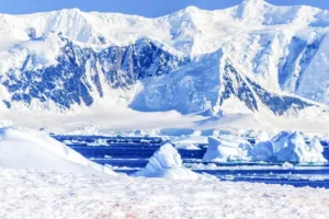
The Meyer Desert is not a desert of dunes and scorching heat. It is a stark, triangular high plateau of rock, gravel and ice-free ground in the heart of Antarctica’s Transantarctic Mountains, near the junction of the mighty Beardmore and Mill glaciers.
Seen from above, it looks like a stone island surrounded by slow-moving rivers of ice.
This isolated plateau sits in the Ross Dependency, some 500 km from the South Pole. For scientists, Meyer Desert is a natural archive: its cliffs and bluffs hold the record of a time when this polar “desert” supported tundra vegetation, running streams and insects. Today, katabatic winds polish the surface, temperatures stay far below freezing, and the landscape feels almost otherworldly.
Antarctica & the Transantarctic Mountains – Regional Setting
To understand Meyer Desert, it helps to zoom out to the scale of the continent.
Antarctica is Earth’s coldest, windiest and driest continent. Much of it qualifies as desert because annual precipitation is extremely low, even though it is buried under an ice sheet up to 4 km thick.
Cutting across this ice-covered world is the Transantarctic Mountains, a 3,500-km-long mountain chain that divides East and West Antarctica. The Dominion Range, where Meyer Desert sits, is part of the Queen Maud Mountains along the western margin of the Ross Ice Shelf. Here, high peaks and plateaus poke through the ice, creating rare ice-free “dry valleys” and rocky deserts.
In this region:
- Beardmore Glacier acts as a giant outlet channel, carrying ice from the East Antarctic interior down to the Ross Ice Shelf.
- Mill Glacier joins Beardmore just below the northern margin of Meyer Desert, framing the plateau between two flowing ice streams.
- Steep bluffs such as Oliver Bluffs cut into the plateau edge, exposing layered sediments of the Meyer Desert Formation.
This combination of high elevation, constant wind and steep ice margins is exactly what allows an ice-free desert surface to persist in the middle of an ice-covered continent.
Landscape & Surface Processes
At first glance, the surface of Meyer Desert seems simple: a gently sloping plateau sprinkled with dark boulders and gravel. Look closer, and a more complex story appears.
Key landscape features include:
- Deflated gravel pavements: Wind removes fine particles, leaving behind tightly packed stones and dolerite granules.
- Periglacial polygons: Repeated freezing and thawing of the shallow ground cracks the surface into geometric patterns, especially near frost-wedged blocks.
- Snow patches and drifts: Only in sheltered hollows does snow linger, sometimes feeding small seasonal melt streams along the plateau edge.
- Escarpments at Oliver Bluffs: Faulting along the Koski fault has dropped blocks of Meyer Desert sediments toward Beardmore Glacier, creating striking cliffs that reveal the interior of the plateau.
Instead of being shaped by flowing rivers, much of the present-day landscape is carved by wind, ice creep, and sublimation. Water rarely flows as liquid; it jumps straight from solid ice to vapor in the dry, cold air. This is a desert sculpted more by absence of water than by its presence.
Meyer Desert Formation – A Window into Warmer Antarctica
Beneath the gravel and frost-shattered rock of today’s surface lies one of Antarctica’s most informative geological units: the Meyer Desert Formation.
This formation is:
- a glacigenic, mostly non-marine sequence of diamictites, sandstones and siltstones,
- up to about 185 m thick at Oliver Bluffs,
- part of the broader Sirius Group, which records changing ice-sheet and climate conditions over millions of years.
Within these layers, researchers find:
- palaeosols – ancient soils that formed under tundra vegetation,
- fluvial deposits – sediments laid down by flowing meltwater streams,
- peat lenses – accumulations of decayed plant material, indicating wet ground.
These features show that Meyer Desert was once home to a cool, moist tundra, not the hyper-arid polar desert seen today. Fossils of plants, insects and molluscs preserved here provide rare insights into that lost enviroment.
Fossil Plants, Insects & Molluscs
For a desert so remote, Meyer Desert has a remarkably rich fossil record. Highlights include:
Neogene Tundra Vegetation
Studies of fossil leaves, seeds and wood from the Meyer Desert Formation reveal at least 18 plant species, including mosses, liverworts, cushion plants and dwarf shrubs.
These assemblages suggest:
- short summers with temperatures reaching a few degrees above freezing,
- patchy, mosaic tundra with wetter hollows and drier ridges,
- a landscape more comparable to modern subantarctic or high-latitude tundra than to the present interior of Antarctica.
Ground Beetles & Other Invertebrates
Fossil elytra (wing cases) of a small carabid beetle, Antarctotrechus balli, have been recovered from Oliver Bluffs. This species is closely related to beetles found today in South America, the Falkland Islands and Tasmania, hinting at ancient biogeographic links across the southern continents.
The presence of beetles, along with other invertebrate fossils, confirms that:
- ice-free ground supported soils and vegetation for long periods,
- there were enough plants and detritus to sustain a small but diverse terrestrial food web.
Freshwater Molluscs
Perhaps most surprising is the discovery of freshwater snails and bivalves in Meyer Desert. A lymnaeid snail fragment and a Pisidium bivalve represent the first known freshwater molluscs from Antarctica, showing that ponds or slow-moving streams once dotted the area.
These fossils demonstrate that at least seasonally unfrozen, liquid-water habitats existed at high latitude and elevation.
Modern Polar Desert Conditions
Today, standing on Meyer Desert, you would see almost none of that former tundra life. The modern environment is dominated by:
- Perennial frost and ice: The ground remains frozen, with only a shallow active layer seasonally softening.
- Hyper-aridity: Soil geochemistry studies show extremely low degrees of chemical weathering and high nitrate contents, consistent with very limited liquid water.
- Katabatic winds: Dense, cold air flows down from the polar plateau, removing snow and exposing bare ground.
- Patchy microbial life: Microorganisms, algae and cryptogams occupy protected microhabitats such as rock cracks, snow-patch margins and moist sediments near occasional meltwater trickles.
In short, Meyer Desert has transitioned from a tundra landscape to a true polar desert, where life survives in scattered refuges.
Why Meyer Desert Matters to Climate Science
What makes this remote desert so important?
- Record of Past Warmth: Fossil plants and soils show that, during parts of the Neogene (especially the Miocene), central Antarctica supported tundra ecosystems under milder conditions.
- Constraints on Ice-Sheet History: The ages and elevations of Meyer Desert sediments help scientists estimate how thick the East Antarctic Ice Sheet was, and how it responded to past global warming episodes.
- Analogue for Future Change: If greenhouse gas levels push global temperatures toward values last seen in the Pliocene, studies of Meyer Desert help researchers ask: how stable is the Antarctic ice sheet?
- Polar Desert Processes: Soil chemistry and surface geomorphology here are benchmarks for understanding how landscapes evolve with almost no liquid water.
In climate discussions, Meyer Desert often appears as a case study linking polar deserts, fossil tundra and ice-sheet stability. It shows that Antarctica has not always been as cold and dry as it looks today.
Visiting & Studying Meyer Desert
Unlike hot deserts that attract adventure tourists, Meyer Desert is visited almost exclusively by scientific teams. The site lies deep within the interior logistics network of the United States and New Zealand Antarctic programs.
Typical fieldwork involves:
- helicopter or small-aircraft access from coastal research hubs such as McMurdo Station,
- temporary field camps on or near the plateau,
- detailed mapping and sampling of the Meyer Desert Formation at Oliver Bluffs and nearby outcrops,
- snow and soil sampling across elevation transects in the Dominion Range.
Because of strict environmental regulations under the Antarctic Treaty System, research teams must:
- minimize disturbance to soil surfaces and fossil sites,
- pack out all waste,
- avoid contamination of sensitive ice and sediment records.
For most people, Meyer Desert will remain a place known only through maps, satellite imagery and scientific reports – yet its story reaches far beyond Antarctica, touching on global questions about climate, biodiversity and planetary change.
Meyer Desert – Key Data
| Continent | Antarctica |
| Region | Ross Dependency, Dominion Range, Transantarctic Mountains |
| Desert type | Cold polar desert (ice-free plateau) |
| Area | ~80 km² (~50 sq mi) |
| Elevation | ~1,700–1,900 m above sea level |
| Nearby glaciers | Beardmore Glacier, Mill Glacier |
| Key formation | Meyer Desert Formation (Sirius Group) |
| Past climate signal | Neogene tundra with mean annual temperature ~–12 °C, summers up to +5 °C |
| Notable fossils | Tundra plants, ground beetle Antarctotrechus balli, freshwater molluscs |
References
- Meyer Desert – Wikipedia
- Meyer Desert Formation – Wikipedia
- British Antarctic Survey – Tundra environments in the Neogene Sirius Group, Antarctica
- Neogene vegetation of the Meyer Desert Formation (Palaeogeography, Palaeoclimatology, Palaeoecology)
- NSF – The Paleoenvironment of the Meyer Desert Formation, Antarctica
- Beardmore Glacier – Regional context