Location & Continent
Continent: Asia
Region: Southern Levant
Country: Israel
Nearby Landscapes: Sinai Peninsula, Mediterranean Coastal Plain (northwest), Arava Valley (east)
Coordinates: 30.6°N, 34.9°E (central reference near the Negev Highlands)
Negev Desert – Map Views
Click to load the interactive map
Photos of the Negev Desert
Physical Features
Area: Commonly cited around 13,000–14,500 km² (varies with boundary definitions)
Shape: A broad triangle that narrows toward the Gulf of Aqaba
Elevation Range: Low basins to high ridges; the highest nearby summit is Mount Ramon at 1,037 m
Signature Landforms: Makhteshim (erosion cirques), limestone ridges, loess plains, wadis, and localized dune fields
Climate & Precipitation
Climate Type: Arid to semi-arid with a strong north-to-south dryness gradient
Rainfall: Roughly 250 mm/year in the north to around 25 mm/year toward the far south
Rain Season: Mainly late autumn to early spring (long, dry summers are typical)
Temperatures: Hot summers with large day-night swings; cool winter nights in higher terrain (one ridge can feel like a different world)
Ecological Features
Biome: Deserts and xeric shrublands
Vegetation Pattern: Patchy cover concentrated in wadis, rocky pockets, and runoff-fed slopes
Key Ecological Process: Short-lived runoff pulses that trigger bursts of growth after rain
Flora & Fauna
Typical Plants: Acacia, tamarisk, salt-tolerant shrubs, hardy grasses, and brief-season wildflowers
Typical Animals: ibex, gazelles, desert foxes, small mammals, reptiles, and migratory birds using open-sky corridors
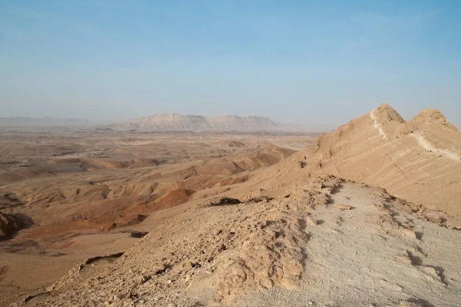
Geology & Notable Features
Rock Story: Resistant limestone and dolomite layers can cap softer rocks, shaping cliffs and basins through erosion
Dust & Soil Story: Windborne silt builds loess blankets in some zones, creating soils that behave differently from sand or bare rock
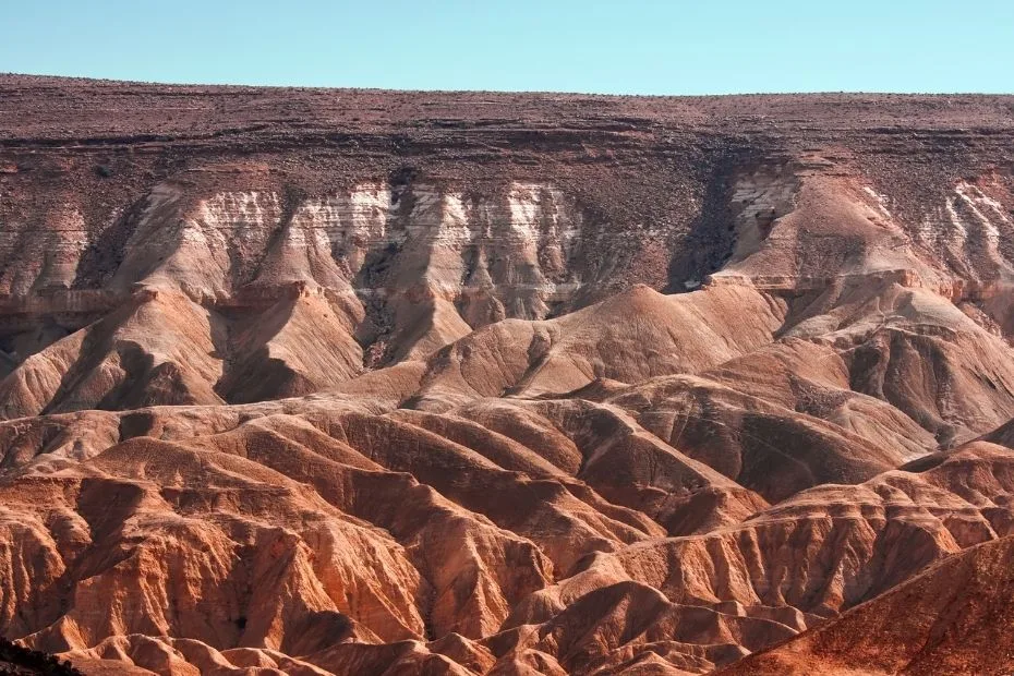
Notable Feature: Makhtesh Ramon (about 40 km long, 2–10 km wide, and up to 500 m deep)
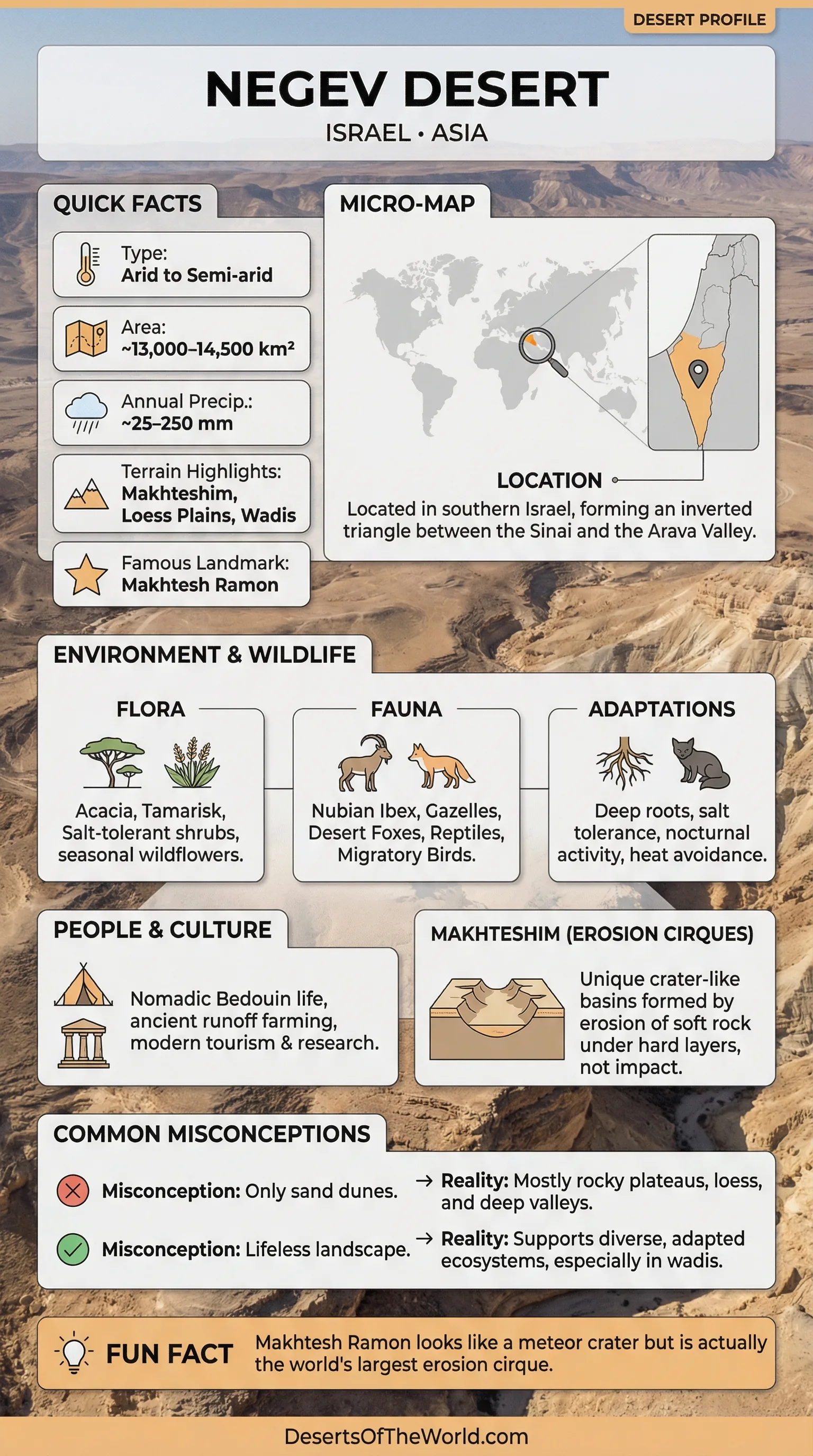
Introduction to the Negev Desert
The Negev Desert is a wide, sunlit sweep of arid and semi-arid terrain in southern Israel, often called the Naqab as well. What makes the Negev stand out is its variety: stone plateaus, chalky ridges, quiet basins, and sudden, sculpted depressions that look like nature pressed a giant thumb into the land.
Where the Negev Sits in the Landscape
On a map, the Negev reads like an inverted triangle that narrows toward the south. To one side, it meets the Sinai Peninsula; to another, it leans toward the Arava Valley. That placement matters, because it helps explain the Negev’s defining trait: rain becomes rarer as the terrain stretches away from wetter coastal influence.
Sub-Regions That Feel Like Different Deserts
People often say “the Negev Desert” as if it is one uniform place. It is more like a library of drylands, with different “shelves” of terrain and climate. A short distance can shift the ground underfoot from loess to exposed rock, and the plants respond immediately.
| Sub-Region | Typical Look | Rainfall Tendency | Ecology Clue |
|---|---|---|---|
| Northern Negev | Open plains with loess soils | Higher end of the Negev gradient | More seasonal plant cover |
| Central Negev | Ridges, basins, and wadis | Moderate-to-low | Life clusters along runoff paths |
| Negev Highlands | High ridges and wide views | Often in the 100–200 mm range | Cooler nights, tough shrubs |
| Southern Arid Zones | Very open desert surfaces | Very low (tens of mm) | Vegetation becomes extremely sparse |
Landforms That Define the Negev
The Negev’s scenery is built from a handful of recurring shapes, each with a clear “rule” behind it. Think of the land as a workshop where wind, water, and time take turns holding the tools. In the Negev, the most recognizable tool mark is the makhtesh.
- Wadis: dry channels that carry water only after storms, acting like quick veins across the surface.
- Loess Plains: fine windblown silt layers that can form crusts and shape runoff patterns.
- Limestone Ridges: tougher rock bands that stand up like the spine of a book.
- Dune Patches: smaller sand accumulations where wind has room to gather and stack grains.
- Makhteshim: steep-walled basins that look like craters, yet come from erosion rather than impact.
Makhtesh Ramon and the “Not-a-Crater” Surprise
Makhtesh Ramon is the Negev’s headline landform: an elongated basin roughly 40 km long, 2–10 km wide, and up to 500 m deep. It resembles an impact crater at first glance, yet it is better imagined as a giant natural mortar bowl, carved as softer layers eroded out from beneath harder caps. The result is a landscape of color-banded rock that can shift from pale limestone tones to warmer sandstone hues within a short walk.
Climate: Rain That Arrives on a Tight Schedule
In the Negev Desert, most rain falls in the cooler months, then the sky locks up for long stretches of summer. This seasonality shapes everything: plants time their growth, animals time their activity, and the ground itself “expects” dryness. Daytime heat and nighttime cooling create big swings in temprature, especially where elevation rises into the Negev Highlands.
Why the Ground Matters: Loess, Rock, and Salt
The Negev isn’t just about climate; it is also about surface physics. In loess-covered zones, fine silt can pack into a crust after rain, so water runs off quickly rather than soaking in. That runoff feeds wadis and small pockets of greenery, creating a patchwork where life concentrates in specific lanes. In other places, salty or stony soils limit what can take root, favoring plants that can handle mineral stress and low moisture.
Water and Wadis: The Desert’s Short-Lived Rivers
A storm in the Negev can turn a dry channel into a moving ribbon within minutes. These flows are brief, yet they do outsized work: they move sediment, reshape banks, and deliver water to trees and shrubs that depend on sudden pulses. For readers trying to “read” the Negev, the simplest clue is to look for green lines that trace wadis like handwriting on a tan page.
Plants: Built for Thrift and Timing
Negev vegetation tends to be either deep-rooted, salt-tolerant, or fast. Some shrubs keep small leaves, waxy coatings, or spines to reduce water loss. Trees like acacias often appear where runoff collects, using the wadi network as a hidden irrigation system. After rain, seasonal wildflowers can appear quickly, like the desert briefly lifting a curtain to show what it can do when water is available.
Animals: Heat-Smart Bodies and Nighttime Schedules
The Negev Desert supports a mix of mammals, reptiles, and birds that treat shade like currency. Many species shift activity to dawn, dusk, or night, avoiding the harshest hours. Hoofed animals such as the ibex are often associated with cliffs and rugged terrain, while smaller creatures use burrows and rock gaps as natural air-conditioning. The most consistent survival “strategy” here is simple: save water, avoid midday, move efficiently.
Geology: A Landscape That Shows Its Layers
The Negev is a rewarding place for anyone curious about rock stories, because the land often exposes its layers clearly. Hard limestones and dolomites can form rims and ridges, while softer chalks and sandstones erode more easily. Over long timescales, that contrast helps create the makhtesh shape: a tough shell around a hollowed interior, drained by a single outlet wadi. It is erosion working with structure, like water following the seams in old stone.
Skies and Visibility: A Desert With a Big Horizon
Clear air is one of the Negev’s quiet superpowers. Low humidity and long dry seasons often bring crisp visibility, especially after weather systems pass. For many visitors, the strongest memory is not a single landmark but the feeling of space: long sightlines, layered ridges, and night skies that can look shockingly deep when light is limited.
Negev Desert Names Worth Knowing
A few terms show up again and again in Negev descriptions, and understanding them makes the region easier to picture. Each word is a shortcut to a specific kind of terrain.
- Makhtesh: an erosion cirque with steep walls and a single drainage outlet.
- Loess: fine windblown silt that can form crusts and runoff-prone surfaces.
- Wadi: a channel that is usually dry, carrying water only after rainfall.
- Xeric Shrubland: dryland plant communities dominated by drought-adapted shrubs.
- Runoff Farming: land use that collects brief flows from slopes and channels to support plants.
References
USGS EROS Cal/Val – Negev Test Site Overview
USGS EROS Cal/Val – Makhtesh Ramon Overview
NASA Earth Observatory – Ramon Crater (Makhtesh Ramon) Image and Explanation
Ben-Gurion University – Desert Meteorology (Blaustein Institutes for Desert Research)
Government of Israel – Geological Survey Report PDF: Atmospheric Dust, Loess, and Soils in the Negev
Israel Nature and Parks Authority – Makhtesh Ramon Nature Reserve and Visitors Center
Negev – Wikipedia (General Background)