Location & Continent
Continent: Africa
Countries: Algeria, Mali
Region: Tanezrouft (part of the Sahara Desert)
Approximate Coordinates: 22.251°N, 2.246°W
Relative Position: West of the Hoggar (Ahaggar) Mountains, near the margins of the Erg Chech sand sea
Tanezrouft Desert – Map and Satellite View
Click to load the interactive map
Physical Profile
| Landscape Type | Hyper-arid plain dominated by reg (gravel desert) and stony plateaus |
| Elevation | ~310 m in commonly cited central areas |
| Relief | Mostly flat and landmark-poor, with scattered sandstone hills and canyon systems in parts of the basin |
| Notable Landforms | Salt flats, folded Paleozoic strata patterns, dune margins near Erg Chech, steep canyon walls (locally very high) |
| Human Footprint | Very sparse; crossed by long-distance desert routes and occasional facilities along corridors |
Climate & Precipitation
The Tanezrouft sits in a band of the Sahara where dryness feels almost absolute.
Many areas receive less than 20 mm of rain per year,
and the most extreme parts of the Tanezrouft Basin are measured in miliimeters—often under
5 mm annually.
That is not “low rainfall.” That is rainfall that barely leaves a trace.
Heat is the other headline.
Summer highs can climb toward 52°C in harsh spells.
Nights can cool quickly because dry air holds little warmth, so daily temperature swings are part of the rhythm.
The result is a place that can feel like a wide-open oven by day and a crisp, silent plain after sunset.
Wind matters as much as temperature.
In the Tanezrouft, frequent dust and sand-laden winds act like a slow sandblaster,
shaving rock surfaces and shifting fine grains into subtle streaks.
With so little vegetation, the ground is exposed, and erosion works fast.
Introduction To The Tanezrouft Desert
The Tanezrouft Desert is often described as one of the Sahara’s most hyper-arid corners.
It lies across southern Algeria and into northern Mali, west of the Hoggar uplands.
In Tuareg languages, its name is commonly linked with the idea of thirst, which fits the landscape’s character.
Older travel writing sometimes used dramatic nicknames, yet the reality is simpler: water is rare, shade is rarer.
What makes the Tanezrouft special is not a single landmark but the way the whole region behaves.
It is a vast, spare stage—flat stretches, stony surfaces, and long horizons.
When people picture “desert,” they often imagine endless dunes.
Here, the dominant texture is more like a stone sea with sand appearing in bands and pockets.
Where The Tanezrouft Fits Inside The Sahara
The Tanezrouft sits near several well-known Saharan features.
It lies west of the Hoggar Mountains and near the edge of the Erg Chech sand sea.
To the south, the land transitions toward northern Mali’s uplands, while to the north and west, terrain opens into broad Saharan expanses.
This positioning helps explain the region’s mix of gravel plains and sand at the margins.
In many descriptions, Tanezrouft is less a sharply bounded “desert” and more a natural region—a recognizable belt of extreme aridity.
That matters for readers because it sets expectations: you are not looking at a single dune field or a single plateau,
but a broad zone where the same rules repeat—dryness, wind, and sparse surface water.
Landforms And Surface Textures
Much of the Tanezrouft is dominated by reg—a surface of pebbles and gravel that can look almost paved from a distance.
These gravel deserts are common across the Sahara, and in the Tanezrouft they help create that famous feeling of emptiness:
very few shrubs, very few visual anchors, just open space.
At the same time, the region is not “featureless” in a geological sense.
Satellite imagery has revealed striking patterns: folded rock strata, looping bands, and exposed layers that resemble wood grain or fingerprints.
These shapes come from ancient rock layes being revealed by persistent wind erosion, plus episodes of water flow in much wetter eras.
The desert can look like minimalist art, except it is built from sandstone and time.
In parts of the Tanezrouft Basin, canyon walls can rise dramatically,
and salt flats appear in low reaches.
Salt flats are a clue: water once pooled or flowed here often enough to leave minerals behind.
Even in a hyper-arid place, the landscape keeps a memory of water.
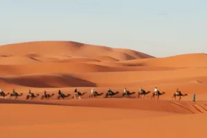
Near the edges—especially closer to the Erg Chech—sand becomes more visible.
Dunes may appear as bands or tongues pushing into the gravel plain.
Think of it like a shoreline: not an ocean shoreline, but a shifting edge where sand meets stone and the boundary moves with the wind.
Common Landform Elements
- Reg surfaces: gravel plains that dominate large areas
- Hamada zones: stony plateaus and hard surfaces
- Sandstone ridges and folded strata patterns
- Salt flats in low-lying pockets and canyon bottoms
- Dune margins and sand sheets near neighboring ergs
Why It Is So Dry
The Tanezrouft sits under large-scale atmospheric patterns that suppress rainfall over much of the Sahara.
Dry air tends to sink here, limiting cloud formation for long stretches.
That creates a baseline of very low precipitation.
Local geography then reinforces the effect: broad plains allow hot air to spread and mix, and there is little surface water to feed humidity back into the air.
When rain does arrive, it is often brief and uneven.
Water can rush through channels and shallow basins, then vanish into the ground or evaporate quickly.
Those rare events still matter.
Over long periods, even occasional floods can carve channels, move sediment, and shape canyon systems—quiet work that becomes visible when the wind strips away loose material.
Water Below The Surface
One of the most intriguing details about the Tanezrouft is that it can sit above deep water-bearing strata.
In other words, the surface may look bone-dry, yet groundwater can exist far below.
That does not mean easy access to water at ground level.
Depth, geology, and distance make it complicated, and in the core Tanezrouft, surface wells are famously scarce.
Still, it helps explain why the Sahara can hide ancient water systems beneath today’s aridity.
The landscape also hints at older, wetter phases.
Scientific work on the region has found evidence that small freshwater lakes existed along margins during parts of the Holocene,
a reminder that “desert” is not a permanent setting everywhere—climate shifts can redraw the map over thousands of years.
The modern Tanezrouft is extreme, yet it is built on a longer story.
Ecology And Living Things At The Edge
Life in the Tanezrouft does not form thick ecosystems.
It appears as scattered, stubborn threads.
In the most hyper-arid zones, visible plant cover can be close to none.
Where conditions soften slightly—along drainage lines, near rocky outcrops, or at the margins—hardy species may appear,
including small shrubs and drought-tolerant plants that wait for rare moisture like a lock waiting for a key.
Animals that persist in and around the Tanezrouft typically rely on stealth, timing, and efficiency.
Many are nocturnal, moving when temperatures drop.
Small mammals, reptiles, and desert-adapted birds are the usual pattern, along with insects that can tolerate heat and dryness.
In a place like this, survival often looks like minimal movement and smart sheltering.
Adaptations Often Seen In Hyper-Arid Sahara Regions
- Night activity to avoid daytime heat
- Burrowing or using rock shade to reduce water loss
- Efficient metabolism and water-saving behaviors
- Opportunistic feeding during rare favorable windows
Human Presence And Desert Routes
The Tanezrouft has historically been avoided for long stays because it lacks the usual desert lifelines—reliable water, recognizable landmarks, steady vegetation.
That said, the Sahara has always been crossed as well as lived in.
Over long time spans, trade routes linked the Niger River corridor with northern Saharan regions such as Tidikelt and Touat,
and the Tanezrouft lay close to parts of that broader network.
In the modern era, long-distance motor routes have crossed the region from north to south,
connecting places in Algeria such as Béchar and Reggane with areas in Mali including corridors toward Gao.
A few sparse stations and posts are associated with these routes.
They are not tourist attractions; they are practical nodes in a vast landscape.
That reality—distance—defines the Tanezrouft as much as heat does.
Today, the region is generally described as having no permanent residents in its harshest core,
with only occasional movement by nomadic groups in wider surrounding areas.
It is a reminder that deserts are not empty in a cultural sense, even when they look empty on the horizon.
Knowledge here is often about routes, seasons, and reading the land’s subtle signals.
What Satellites Reveal About The Tanezrouft Basin
The Tanezrouft Basin is famous in remote sensing because it shows geology with almost no cover.
With little vegetation and very thin soil, rock structures stand out sharply from above.
Satellite images have highlighted concentric sandstone patterns,
canyon networks, and bright salt flats that gleam in dry basins.
It is one of those places where Earth’s surface looks like a diagram.
Observations from space also show how human lines cut through a huge natural canvas.
Roads appear as pale threads across darker ground, sometimes running toward cities such as In Salah in central Algeria.
From above, even a simple track becomes visible for miles.
On the ground, it can feel like a whisper in a sea of stone.
This is why the Tanezrouft appears in science galleries and Earth observation collections:
it offers clean, readable signals of wind-driven erosion and ancient rock structure.
The desert is harsh, yes, but it is also an open book—one written in sandstone and long time.
How To Recognize Tanezrouft In Photos
The Tanezrouft does not always look like the “classic” dune desert.
In many images, the main impression is texture:
pebbly surfaces, dark rock, pale salt, and occasional yellow sand bands.
The palette can be subtle until the light hits at an angle, then the surface suddenly shows patterns—folds, loops, and stripes.
If a photograph includes both stony plain and a sharp band of dunes at the margin, it often tells the same story:
the Erg pushes, the Reg resists, and wind negotiates between them.
This boundary is one of the easiest visual signatures to remember, and it helps separate Tanezrouft imagery from dune-only deserts.