Location & Continent
Continent: Africa
Countries: Niger, Chad
Region: South-central Sahara Desert, between the Aïr Mountains and the Lake Chad basin
Coordinates (approx.): 17.6°N, 10.9°E
Ténéré Desert – Map View
Physical Features
Area: ≈ 400,000 km²
Average Elevation: around 430 m above sea level
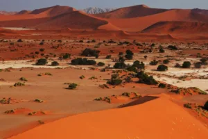
Landscape Types: wide sand sheets, tall ergs (sand seas), hard regs (gravel plains), and low rocky outcrops such as the “Blue Mountains”
Climate & Precipitation
Climate Type: Hot desert climate (BWh), hyper-arid
Temperature: summer daytime highs often above
40 °C and locally approaching 50 °C
Precipitation: typically 10–25 mm per year or less
Sunshine: among the shiniest places on Earth, with very high sunshine duration and cloud-free skies
Ecological Features
Ecozone: Saharan desert
Protected Areas: western Ténéré is part of the
Aïr and Ténéré Natural Reserves, a UNESCO World Heritage Site
Flora & Fauna
Flora: sparse drought-resistant shrubs, scattered acacias, and occasional grasses; the Aïr–Ténéré reserve hosts roughly 300 higher plant species
Fauna: habitat for endangered antelopes (addax, dama gazelle, dorcas gazelle), fennec fox, Rüppell’s fox, and the Sahel cheetah
Geology & Notable Features
Origin: part of the Central Sudan depression and once linked to a larger Lake Chad system
Key Landforms: the Erg of Bilma, the Kaouar cliffs with oases like Bilma, low hills such as Adrar Madet, and the nearby volcanic Aïr Mountains
Introduction to the Ténéré Desert
The Ténéré Desert is often described as the
“desert within the Sahara” – a place of vast sand, sky, and silence.
The name “Ténéré” comes from the Tuareg language and is often
translated as “desert” or “desert beyond the desert”.
Where Exactly Is Ténéré?
The region forms a huge basin in the central Sahara, framed by the Aïr Mountains, the Hoggar massif, the Djado Plateau, the Tibesti Mountains, and the Lake Chad basin.
Most of Ténéré lies in the Agadez Region of Niger, with extensions into western Chad. Towns like Dirkou, Bilma, and Agadem punctuate the otherwise empty landscape.
Landscape: An Ocean of Sand and Stone
Northern Ténéré features vast sand sheets, while the Erg of Bilma contains long, parallel dunes historically used by salt caravans.
The Kaouar cliffs host oases such as Bilma and Fachi; scattered inselbergs like the Blue Mountains rise as natural waymarks.
Climate and Weather
Daytime temperatures exceed 40 °C for much of the year, sometimes nearing 50 °C. Rainfall is extremely rare (10–25 mm annually).
Sandstorms can occur during brief storms, but the sky is usually clear, making Ténéré one of the most sun-drenched places on Earth.
Life in Ténéré: Flora & Fauna
Vegetation appears only in small patches – acacias, shrubs, and seasonal grasses. The surrounding reserve contains around 300 plant species.
Wildlife includes addax, dama gazelle, dorcas gazelle, fennec fox, and occasionally the Sahel cheetah.
The Tree of Ténéré
Once the world’s most isolated tree, this acacia stood alone near a caravan well until it was knocked down in 1973. A metal sculpture now marks the site.
Ténéré, Niger and the Sahel
Oases like Bilma have long produced salt and dates, linking Saharan caravan trade with sub-Saharan routes.
Traditional Tuareg culture, camel caravans, and the Aïr Mountains remain central to Niger’s identity.
Aïr and Ténéré Natural Reserves & Conservation
This protected reserve spans 7.7 million hectares, conserving species such as the addax, dama gazelle, and dorcas gazelle.
Threats include climate stress, illegal hunting, overgrazing, mining, and insecurity.
Human Traces
The Ténéré region was once wetter, home to lakes, grasslands, early humans, and large fauna. Sites like Gadoufaoua contain important fossils.
Tuareg caravans historically crossed Ténéré using long-established routes aligned with wells and oases.
Travel and Safety
Travel requires expert guides, safety planning, and respect for local communities. Conditions can be harsh, distances vast, and connectivity limited.
Visitors may enjoy camel treks, 4×4 expeditions, and star-filled desert nights when routes are open.