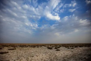
Note: Although the Bromo Sand Sea is commonly described as a “desert” due to its vast sandy appearance, it is not a true climatic desert. Instead, it is a volcanic sand plain formed by repeated eruptions within the Tengger Caldera and receives significant annual rainfall.

Location & Continent
Continent: Asia
Country: Indonesia
Island/Region: East Java, Tengger Caldera
Coordinates: 7°56′S, 112°57′E
Click to load the interactive map
Photos of the Bromo Sand Sea
Physical Features
Area: ~5,250 hectares
Elevation: ~2,100 m within Tengger Caldera
Notable Landforms: Volcanic ash plains, shifting sand fields, steep crater walls
Climate & Precipitation
Temperature: Daytime 15–20°C, nights can drop to 5°C or lower
Precipitation: ~2,500 mm annually; most rainfall between November and March
Ecological Features
Ecozone: Tropical montane volcanic environment
Biome: Montane grasslands and shrublands
Ecoregions: Java montane forests
Flora & Fauna
Flora: Sparse grasses, shrubs, volcanic ash–adapted plants
Fauna: Javan rusa deer, wild boar, Javan leopard (rare), birds of prey, and small mammals
Geology & Notable Features
Geology: Formed from volcanic eruptions within Tengger Caldera; dominated by volcanic ash and sand deposits
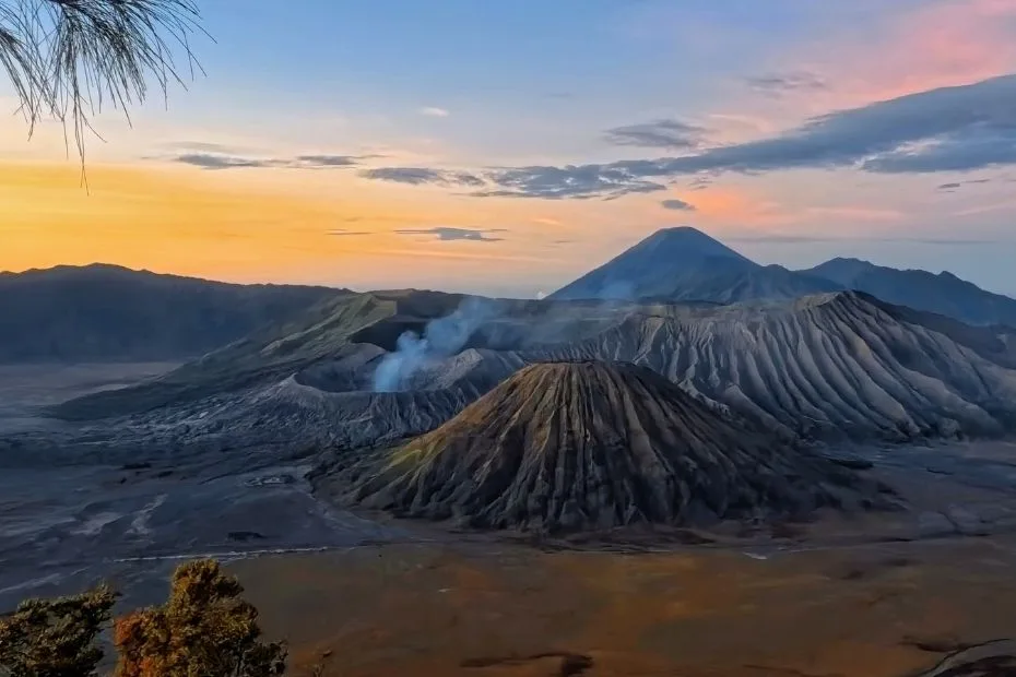
Notable Features: Mount Bromo, Batok, and Semeru volcanoes rising from the Sand Sea
Introduction
The Bromo Sand Sea, known locally as Pasir Berbisik, is a desert area in East Java, Indonesia. The landscape and cultural setting draw many visitors each year. This section examines its geography, climate, ecology, and tourism, and compares it with other desert regions.
Geography of the Bromo Sand Sea
The Bromo Sand Sea lies within the Bromo-Tengger-Semeru National Park and covers about 5,250 hectares. It consists of volcanic sand deposited by eruptions from Mount Bromo. The area is bordered by volcanic peaks, grasslands, and forested slopes.
Key Geographic Features
Some of the prominent geographic features of the Bromo Sand Sea include:
| Feature | Description | Height/Size |
|---|---|---|
| Mount Bromo | Active volcano, a major attraction with stunning panoramic views. | 2,329 meters |
| Mount Semeru | The highest mountain in Java, known for its majestic beauty and active status. | 3,676 meters |
| Teletubbies Hill | Rolling green hills that offer picturesque landscapes and hiking opportunities. | N/A |
| Sand Sea | Vast expanse of volcanic ash and sand, creating a unique desert environment. | ~10 km² |
Climate Conditions
The Bromo Sand Sea experiences a distinct climate that contributes to its unique ecosystem. The area’s elevation leads to a range of weather patterns:
- Temperature: Ranges from 5°C to 20°C, with cooler temperatures during the evenings.
- Rainfall: Receiving around 2,500 mm of rain annually, mainly from December to February.
- Dry Season: The dry season occurs from April to October, creating perfect conditions for trekking and tourism.
Ecology of the Bromo Sand Sea
The Bromo Sand Sea supports a diverse range of flora and fauna. Adaptations to its arid conditions lead to a unique biotic community:
- Flora: While the dominant vegetation is dominated by grasses and shrubs, you can also find endemic species such as the edelweiss.
- Fauna: Various species inhabit the region, including the Javanese bull and numerous bird species such as the Java Hawk-Eagle and Javan Myna.
Tourist Attractions
One of the key aspects of the Bromo Sand Sea is its appeal to tourists. Here are some of the top attractions:
- Sunrise at Mount Bromo: A must-see experience where visitors hike pre-dawn to witness the breathtaking view of the sunrise over the volcanic landscape.
- Horseback Riding: Local guides offer horseback rides across the Sand Sea, providing an exhilarating way to explore.
- Photography Hotspots: The unique barren landscapes combined with the surrounding mountains create stunning photographic opportunities.
Comparative Analysis
To better understand the Bromo Sand Sea, it’s essential to compare it with other desert regions:
| Attribute | Bromo Sand Sea | Sahara Desert | Gobi Desert |
|---|---|---|---|
| Size | 5,250 hectares | 9,200,000 km² | 1,295,000 km² |
| Climate | Mild, with moderate rainfall and cooler evenings | Very high temperatures and low annual rainfall | Cold winters and hot summers, with low precipitation |
| Flora/Fauna Diversity | High, with unique species | Low, primarily desert-adapted species | Moderate, with endemic and migrant species |
Conclusion
The Bromo Sand Sea is a remarkable desert ecosystem that offers a unique blend of natural beauty and rich cultural experiences. Its stunning landscapes, coupled with diverse wildlife and favorable climate conditions, make it an ideal destination for both adventure seekers and those who appreciate nature’s artistry. A visit to this enchanting place is not just a trip to a desert, but an invitation to explore one of Indonesia’s most beautiful natural wonders.