Location & Continent
Continent: Africa
Countries: Eritrea, Djibouti
Coordinates (approx.): 13°N, 42°E – along the southern Red Sea coast
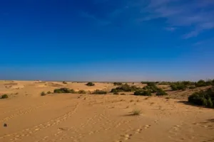
The Eritrean Coastal Desert is a narrow strip of sand and gravel plain running along the southern coastline of Eritrea and the adjacent Red Sea shore of Djibouti. This coastal belt forms the land bridge between northeastern Africa and the Arabian Peninsula, sitting close to the busy Bab-el-Mandeb Strait. Although it looks empty at first sight, it still hold a surprising amount of life and plays a key role in regional climate, ecology and bird migration.
Eritrean Coastal Desert – Map & Street View
Physical Features
Area: About 4,400 km² (~440,000 ha) of coastal desert plain
Length: Roughly 450–500 km along the southern Red Sea coast
Width: Mostly a narrow belt, often 20–60 km wide from shore to inland hills
Elevation: From sea level up to about 200 m, with nearby volcanic rises linked to the Danakil region
The surface is dominated by flat sand sheets, gravel plains and isolated rocky outcrops. Inland, the desert blends into broader xeric grasslands and low plateaus connected to the Afar Depression, one of the hottest and most geologically active zones on Earth.
Climate & Precipitation
Climate type: Hot desert climate (hyper-arid)
Temperature: Mean daily maximum around 33 °C, mean minimum near 27 °C – among the highest night-time averages in Africa
Rainfall: Typically <100 mm/year, highly variable from year to year
Seasonality: Long, hot and humid summers; short, slightly cooler and drier winters
Along the Red Sea coast, air can feel almost wet despite the lack of rain, because warm sea water feeds constant humidity. Winds from the sea and from the broader Danakil Desert shape dust storms, haze, and fine salt-laden mists that drift inland on some days.
Ecological Features
Ecozone: Afrotropical realm
Biome: Deserts and xeric shrublands
Ecoregion code: AT1304 – Eritrean Coastal Desert (recognized by WWF and other conservation initiatives)
The landscape is a mix of open steppe, sparse shrublands, and pockets of halophytic vegetation near salty flats and lagoons. Close to the shoreline, mangrove stands fringe a few sheltered creeks, creating nursery habitat for fish and invertebrates that link the desert with the Red Sea.
Flora & Fauna
Flora: Drought-tolerant grasses such as Panicum turgidum and Lasiurus scindicus, herbs like Aerva javanica, and scattered trees of Acacia tortilis and Acacia asak, with shrubs including Rhigozum somalense and Caesalpinia erianthera.
Fauna: The ecoregion hosts Dorcas gazelle, Soemmerring’s gazelle, and Salt’s dik-dik, along with sea turtles nesting on remote beaches. Three near-endemic reptiles stand out: the Ogaden burrowing asp, Ragazzi’s cylindrical skink, and the small gecko Hemidactylus flaviviridis.
The coastal strip serves as a major raptor migration flyway. Each year, hundreds of thousands of buzzards, eagles, and other soaring birds pass through the Bab-el-Mandeb Strait, using rising desert air currents to travel between Eurasia and Africa.
Geology & Notable Features
Geology: The basement is built of volcanic lavas that descend from the Ethiopian and Eritrean highlands toward the Red Sea, overlain by thin, loose regosols and wind-blown sands.
Notable features: The desert includes offshore archipelagos such as the Sept Frères Islands of Djibouti, low coral terraces, salt flats, and gently rolling gravel plains. Together these create a stark but beautiful transition from Red Sea waters to the inland Danakil landscapes.
Introduction to the Eritrean Coastal Desert
The Eritrean Coastal Desert is one of the hottest and driest corners of the Horn of Africa. Stretching from southern Eritrea to northern Djibouti, it hugs the southern Red Sea just before the waters squeeze through the narrow Bab-el-Mandeb gateway. On maps it looks like a thin pale ribbon, but in reality it is a complex ecoregion where shifting dunes, rocky plains, and coastal shallows meet.
This desert forms part of the broader South Red Sea & Gulf of Aden coastal drylands, linking Africa and Arabia. Although Eritrea and Djibouti are relatively small countries, they lie along a major maritime corridor, and this low, hot desert extends along the coast behind it.
Geography and Regional Setting
On the Eritrean side, the desert lies mainly within the Southern Red Sea Region, a long, narrow strip that follows the coast for over 500 km while remaining only about 50 km wide. Inland, the land rises abruptly into volcanic hills and the stark Danakil or Dankalia plateau, while offshore the Dahlak Archipelago and other islands extend into the Red Sea.
Towns are few. Assab (Asseb) in Eritrea and Obock in Djibouti punctuate the shoreline, but much of the coast is almost empty except for small Afar settlements, seasonal fishing camps, and isolated salt-working sites. The narrow coastal road and rough desert tracks connect these communities to inland cities such as Asmara and Djibouti City, yet travel can be slow under the intense heat.
Climate and Weather Patterns
For most of the year, the desert air feels like a dry, moving oven. Daytime highs often climb beyond 35 °C, while nights frequently remain close to 27 °C. Even in the “cooler” months, temperatures along the Red Sea coast rarely drop much, giving the region some of the most consistently warm minimum temperatures on the continent.
Rain is scarce and erratic. Some years, scattered showers briefly green the plains; other years pass with almost no measurable rainfall. When storms do arrive, they can trigger sudden flash floods through normally dry wadis, carving fresh channels across the flat desert. Dust-laden winds, combined with sea breezes from the Red Sea, shape the fine sediments and keep visibility low on hazy days.
Ecosystems, Flora and Plant Adaptations
Vegetation here is all about survival. Clumps of Panicum turgidum, Lasiurus scindicus, and other grasses anchor the dune sands, while the hardy shrub Rhigozum somalense spreads its tangled branches to capture every drop of moisture. Deep-rooted Acacia tortilis and Acacia asak trees dot the plains, providing rare shade for wildlife and people alike.
Many plants have small, waxy leaves, or shed their leaves completely during extreme drought, reducing water loss. Some produce seeds that can lie dormant in the soil until an unpredictable rain event, when the desert briefly bursts into a thin flush of green. Along salty inlets, halophytic species tolerate high salinity, and scattered mangroves knit together mud and sand, stabilising the fragile coastline.
Wildlife and Migration Corridors
Mammal life is relatively sparse but specialised. The graceful Dorcas gazelle, Soemmerring’s gazelle, and the tiny Salt’s dik-dik browse on shrubs and grasses, often moving at dusk and dawn to avoid the fiercest heat. Tracks of foxes and other small carnivores weave through the gravel, while offshore waters host dolphins, fish and invertebrates linked to nearby coral reefs.
Reptiles are particularly important here. The near-endemic Ogaden burrowing asp, Ragazzi’s cylindrical skink, and an Indian leaf-toed gecko thrive in loose sandy soils and rocky crevices. Along the beaches, sea turtles come ashore to nest on remote stretches of sand. Above all, the desert’s sky becomes a moving river each migration season as steppe eagles, buzzards, and many other raptors cross from Yemen to Africa, using rising warm air over land to glide with minimal effort.
People, Culture & Coastal Life
Despite its harshness, the Eritrean Coastal Desert is not empty of people. Small communities, many of them Afar pastoralists and fishers, move between the coastal plains and nearby uplands with their herds of goats, sheep and camels. Traditional knowledge of wells, seasonal grazing and safe routes across the flats is vital for survival in a land where water is the most valuable resource.
In port towns like Assab and Massawa, the desert meets the sea in a different way. Here, simple harbours, salt pans and small markets tie the local economy to Red Sea shipping lanes. Fishing, small-scale trade and services for passing vessels mix with the rhythms of desert life, giving this corner of Eritrea and Djibouti a distinct maritime-desert culture.
Environmental Challenges & Conservation
The ecoregion is still considered relatively intact, but it faces growing pressure. Overgrazing by livestock can strip already sparse vegetation, exposing soils to erosion. Hunting of gazelles, turtles, and seabirds, together with disturbance along beaches and coastal inlets, can reduce wildlife numbers in a system that recovers slowly from any damage.
Planned or existing infrastructure, such as coastal roads, ports and energy projects, may fragment habitats and increase human access to previously remote breeding and feeding sites. At the same time, rising sea levels and warmer waters linked to climate change threaten mangroves and near-shore ecosystems. For long-term protection, experts highlight the need for targeted protected areas, better monitoring of raptor migration, and community-based management that supports both people and the desert’s unique nature.
Travel, Access & Responsible Tourism
Visiting the Eritrean Coastal Desert is still a niche experience. Limited infrastructure, permit requirements, and political sensitivities mean that most travellers explore the area through guided trips starting in Asmara, Massawa, or occasionally Assab. Journeys may include drives across the coastal plain, visits to remote beaches, or excursions by boat to nearby islands and reefs.
Because the environment is fragile, simple choices make a real difference: carrying out all waste, avoiding disturbance of nesting turtles and resting birds, staying on established tracks, and supporting local guides and community-run services. Done carefully, low-impact tourism can provide income for residents while keeping the silence and wide open horizons that define this coastal desert.