
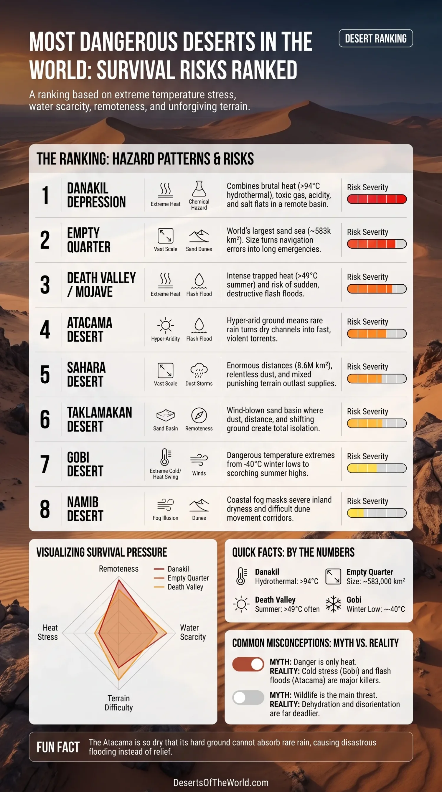
A desert does not become dangerous because of heat alone. The hardest places to survive combine extreme temperature stress, little reliable water, long travel distances, limited rescue access, and terrain that makes small errors harder to correct. Dust, sudden floodwater, corrosive salt flats, and deep dune fields can reduce the margin for error even further. This ranking weighs survival risk for an unprepared person on the ground rather than fame or scenery.
| Rank | Desert | Main Hazard Pattern | Why It Lands Here |
|---|---|---|---|
| 1 | Danakil Depression | Extreme heat, acidic hydrothermal zones, salt, toxic gas, remoteness | Few places combine severe heat with chemically hostile ground conditions across such a compact area. |
| 2 | Empty Quarter | Scale, water scarcity, shifting dunes, navigation failure | Its size can turn a navigation or fuel problem into a prolonged emergency. |
| 3 | Death Valley / Mojave | Very high heat, trapped basin warmth, low rainfall, flash floods | Heat exposure is among the most severe on Earth, although roads and rescue access are better than in larger remote deserts. |
| 4 | Atacama Desert | Hyper-aridity, strong sun exposure, rocky terrain, rare but violent flooding | Long dry periods can be interrupted by rainfall that sends fast runoff through normally dry channels. |
| 5 | Sahara Desert | Huge distances, heat, dust, mixed terrain, sparse water | Its scale can exceed available supplies, fuel range, and navigation margins. |
| 6 | Taklamakan Desert | Wind-blown sand, dry climate, high evaporation, remoteness | Dust, distance, and shifting sandy terrain combine to make movement and route finding difficult. |
| 7 | Gobi Desert | Severe cold, hot summers, dry winds, large temperature swings | Danger comes from cold exposure and wide temperature variation as well as summer heat. |
| 8 | Namib Desert | Fog-fed coast, rainless margins, dunes, heat inland | Coastal fog can mask severe water scarcity, while dunes and inland heat complicate travel. |
How the Ranking Was Built
This list gives the most weight to temperature stress, water scarcity, distance from help, terrain that slows movement, and weather that changes ground conditions quickly. Wildlife receives less weight because dehydration, heat illness, cold exposure, dust-related disorientation, and flash flooding account for more common survival threats in remote desert travel.
- Heat Load: How quickly sun, hot air, and dry conditions can overwhelm the body’s ability to regulate temperature.
- Water Reality: How little usable surface water is available and how far a traveler may need to move between dependable sources.
- Rescue Difficulty: The effect of roads, settlements, communications, terrain, and travel time on emergency response.
- Navigation Pressure: The extent to which dunes, dust haze, broad plains, and repeated landforms increase route-finding errors.
- Weather Instability: The possibility that storms will produce mud, debris flows, flooded channels, or closed routes after long dry periods.
1) Danakil Depression
The Danakil Depression ranks first because several hazards occur in the same region. The lowland environment combines high temperatures, below-sea-level terrain, extensive salt deposits, hydrothermal activity, and limited access.
Water entering parts of the basin has no outlet to the sea and is removed mainly through evaporation. Around Dallol, hydrothermal waters can exceed 200°F (94°C), while some pools have very low pH and heavy salt concentrations. Travelers therefore face heat from the atmosphere alongside unstable, saline, and chemically aggressive ground conditions.
- Heat Exposure: High air and ground temperatures increase water loss and reduce opportunities for physical recovery.
- Rescue Difficulty: Harsh surfaces, sparse infrastructure, and isolated volcanic and salt landscapes restrict safe access routes.
- Local Hazard Mix: Acidic springs, toxic gases, salt flats, geothermal features, and extreme heat occur within a relatively small area.
2) Empty Quarter
The Empty Quarter, or Rub’ al Khali, is less chemically hostile than the Danakil Depression, but it presents severe logistical risk. It covers about 583,000 square kilometers and forms the largest continuous sand desert on Earth. Distances between roads, settlements, and dependable water sources can be very large.
Deep dunes and interdune flats slow vehicles and people, raise fuel consumption, and complicate recovery after a breakdown. Repeated dune patterns also provide few fixed visual references, allowing small navigation errors to grow over long distances.
- Main Survival Pressure: Severe water scarcity combined with long travel distances.
- Terrain Problem: Loose sand slows movement, drains energy, and makes vehicle extraction difficult.
- Navigation Difficulty: Long interior routes and repeated landforms reduce opportunities to recognize and correct a wrong course.
3) Death Valley / Mojave
Death Valley would rank near the top if heat strain were the only measure. Summer temperatures often exceed 120°F (49°C) in the shade, overnight lows may remain between 85°F and 95°F, and average annual rainfall is below 2 inches. The low basin and surrounding mountains help retain heat, limiting overnight cooling during the hottest periods.
Death Valley ranks below the Danakil Depression and Empty Quarter because it has more roads, weather monitoring, visitor facilities, and rescue capacity. The physical danger remains severe. Occasional storms can also produce flash floods, road damage, and debris flows across ground that is dry for most of the year.
- Heat Exposure: High nighttime temperatures shorten the period available for cooling and recovery.
- Flood Risk: Heavy rainfall can send destructive runoff through canyons, washes, and low roads.
- Access Advantage: Established roads and emergency services reduce some of the remoteness risk found in the two higher-ranked deserts.
4) Atacama Desert
The Atacama is the driest non-polar desert on Earth. Long-term moisture scarcity leaves many surfaces hard, bare, and poorly suited to absorb sudden rainfall. Water can therefore move rapidly across the ground when an unusual storm reaches the region.
Rainfall totals that would be modest elsewhere may equal several years of normal precipitation in the driest parts of the Atacama. Dry channels can become fast-moving flows carrying mud, rocks, and debris. Survival risk comes from hyper-aridity, intense solar exposure, sparse water, and sudden flooding in locations that normally appear inactive.
- Main Survival Pressure: Hyper-aridity, strong sun exposure, and very limited natural water.
- Rare-Rain Flood Risk: Unusual storms can produce damaging runoff because ultra-dry surfaces absorb little water.
- Reason for Its Rank: The Atacama combines severe dryness with ground conditions that respond poorly to sudden rain.
5) Sahara Desert
The Sahara is the largest hot desert on Earth, covering roughly 8.6 million square kilometers across northern Africa. It includes dune fields, gravel plains, rocky plateaus, mountain ranges, dry valleys, seasonal basins, and oasis depressions. Each terrain type creates different limits for walking, driving, water planning, and navigation.
Dust adds another hazard. The Sahara is the largest source of long-range transported mineral dust, and local dust events can reduce visibility, irritate the respiratory system, conceal tracks, and disrupt route finding. The combination of heat, distance, terrain changes, and sparse water can wear down travelers long before a single acute emergency develops.
- Main Survival Pressure: Large distances combined with heat, dust, and irregular water access.
- Why It Is Not Higher: Some regions contain established communities, transport corridors, and known travel routes.
- Terrain Range: Risk changes sharply between dunes, rocky plateaus, gravel plains, mountains, and dry basins.
6) Taklamakan Desert
The Taklamakan is one of the world’s largest sandy deserts and occupies the Tarim Basin, which is bordered by high mountain systems. The surrounding relief contributes to aridity and isolates a broad interior of dunes, dry plains, and wind-blown sediment. The desert covers about 130,000 square miles.
Low precipitation, high evaporation, frequent dust, and moving sand create difficult travel conditions. Spring and summer dust storms can reduce visibility and cover tracks or roads. The desert does not require record daily heat to remain dangerous because route finding, vehicle movement, and access to water are difficult across much of the basin.
- Main Survival Pressure: Isolation, moving sand, and narrow navigation margins.
- Dust Problem: Dust and sand storms can sharply reduce visibility and alter surface conditions.
- Reason for Its Rank: Sandy basin terrain makes sustained movement and route correction harder than in much of the Gobi.
7) Gobi Desert
The Gobi shows why desert danger is not limited to extreme heat. Winter lows can reach about −40°F (−40°C), while summer highs can approach 113°F (45°C). This annual range places heavy demands on clothing, shelter, vehicles, water storage, and seasonal planning.
The Gobi is dry, continental, and exposed to strong winds, with wide day-to-night temperature changes in many areas. Heat illness may dominate during summer travel, while hypothermia, frostbite, and impaired dexterity become greater concerns during winter and cold nights.
- Main Survival Pressure: Wide temperature variation rather than continuous extreme heat.
- Cold Exposure: Low temperatures and wind can impair judgment, movement, and the use of equipment.
- Seasonal Planning: Travelers may face dehydration and cold stress in the same region at different times of year or elevation.
8) Namib Desert
The Namib has milder coastal temperatures than several deserts ranked above it because the cold Benguela Current brings frequent fog to the shoreline. That atmospheric moisture does not provide dependable drinking water for travelers, and the coastal strip remains almost rainless. Conditions become hotter and drier farther inland.
Large dune systems, gravel plains, salt and clay pans, and restricted movement corridors complicate travel. Coastal fog can reduce visibility, while inland heat and sparse surface water raise dehydration risk. These pressures place the Namib eighth rather than removing it from the ranking.
- Main Survival Pressure: Apparent atmospheric moisture alongside severe scarcity of usable surface water.
- Terrain Problem: Dunes and pans limit route choices and can slow vehicles or people.
- Reason for Its Rank: Coastal moderation lowers heat stress in some areas, but water and movement hazards remain.
Why Rare Rain Can Be More Dangerous Than Constant Drought
Desert danger does not rise in a simple line as rainfall decreases. In places such as the Atacama and Death Valley, rare storms can trigger rapid runoff because dry, compacted, rocky, or salt-rich surfaces absorb little water. Channels that remain dry for long periods may become active paths for water, mud, rocks, and debris. Flash flood risk therefore belongs in any desert danger ranking.
Sparse vegetation also provides little resistance to moving water or eroded material. Flooding may begin far from the place where rain is visible, especially in canyons and drainage networks. Travelers should treat washes, narrow valleys, low crossings, and canyon floors as flood routes during unsettled weather.
Why Cold Deserts Belong on the Same List as Hot Ones
The Gobi provides the clearest example, while winter conditions in the Taklamakan can create similar concerns. A desert does not need tropical heat to place the body under severe stress. Cold lowers dexterity, slows decision-making, and can lead to hypothermia, especially when wind, wet clothing, fatigue, or inadequate shelter are involved.
Desert danger is not limited to extreme heat. A useful ranking must also account for cold stress, dust exposure, navigation difficulty, and rescue access. These hazards can become life-threatening even when daytime temperatures are moderate.
Sources
- U.S. National Park Service — Death Valley Weather and Climate (record heat, rainfall, basin heat retention, overnight temperatures)
- U.S. National Park Service — Death Valley Flash Floods (recent flood history in an arid desert setting)
- NASA JPL — Detecting Life in the Ultra-Dry Atacama Desert (Atacama as the driest non-polar desert and a high-radiation hyper-arid environment)
- NOAA Climate.gov — Flooding in Chile’s Atacama Desert After Years’ Worth of Rain in One Day (rare-rain flood behavior in ultra-dry terrain)
- NASA Earth Observatory — Empty Quarter (scale of Rub’ al Khali and sand sea structure)
- Encyclopaedia Britannica — Sahara (size, terrain variety, and physical geography)
- U.S. Geological Survey — The Antiquity of the Sahara Desert (Saharan dust transport and regional aridity context)
- Encyclopaedia Britannica — Gobi Climate (extreme annual temperature range and low precipitation)
- U.S. Geological Survey ECCOE — Taklamakan Desert (wind-blown sand hazards, low precipitation, and high evaporation)
- NOAA NESDIS — The Snowy Peaks of Central Asia (Taklamakan remoteness and dust storm behavior)
- Encyclopaedia Britannica — Namib (fog, coastal dryness, inland heat, and dust behavior)
- NASA Astrobiology — The Message of Really, Really Extreme Life (Danakil hydrothermal heat, salt, and acidity)
- CNRS Images — Danakil Depression Hot Springs (multi-extreme conditions including very high temperatures, salinity, and toxic gas)
- Encyclopaedia Britannica — Denakil Plain (below-sea-level basin, salt flats, and evaporation setting)