Location & Continent
Continent: North America
Country: United States (primarily Idaho, reaching toward eastern Oregon and western Wyoming)
Coordinates: ~43.5°N, 113.5°W
Snake River Plain – Map & Street View
Physical Features
Area: ~55,000 km² (the plain covers roughly a quarter of Idaho)
Length: ~640 km (about 400 miles, curving westward from Wyoming to the Idaho–Oregon border)
Elevation: Commonly 1,100–1,900 m (3,600–6,200 ft) across lava plains and terraces, lower toward western valleys and higher along basalt-capped buttes.
The Snake River Plain is a broad, bow-shaped volcanic lowland that slices across the northern Great Basin and central Rockies. Most of Idaho’s major cities and farms sit on this gently sloping surface, cut by deep canyons like the one at Twin Falls.
Climate & Precipitation
Temperature: Hot, sunny summers (often 30–35 °C, peaks > 38 °C/100 °F) and cold, snowy winters (lows frequently < −15 °C/5 °F)Precipitation: ~150–250 mm annually on the Eastern Snake River Plain; semi-arid cold-desert (BSk) regime with high evaporation and strong spring precipitation pulse.
Because the Plain forms a wide “moisture corridor” through surrounding mountains, Pacific air can track inland and drop snow on the region’s eastern rim—while the interior stays dry and sunny much of the year.
Ecological Features
Ecozone: Nearctic
Biome: Temperate cold desert & semi-arid sagebrush steppe
Ecoregions: EPA Level III “Snake River Plain,” including subregions such as the Eastern Snake River Basalt Plains, Mountain Home Uplands, Magic Valley, and Upper Snake River Plain
Much of the landscape is sagebrush steppe over thin loess and basalt—open, wind-polished country where shrubs, bunchgrasses, and hardy forbs are adapted to big temperature swings and summer drought.
Flora & Fauna
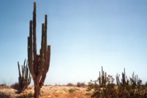
Flora: Big sagebrush (Artemisia tridentata) communities with rabbitbrush, greasewood, saltbush, bluebunch wheatgrass, Indian ricegrass, and Thurber needlegrass; invasive cheatgrass is widespread on disturbed sites
Fauna: Pronghorn, mule deer, coyotes, badgers, black-tailed jackrabbits, pygmy rabbits, sagebrush lizards, burrowing owls, ferruginous hawks, and greater sage-grouse use the shrub-steppe mosaic; salmon and steelhead run the Snake River mainstem and tributaries downstream of the Plain’s canyons.
Geology & Notable Features
Geology: The Plain records the track of the Yellowstone hotspot: thick rhyolite under basalt sheets in the east, and a fault-bounded western basin filled by Lake Idaho sediments and lava. Volcanic buttes and young lava fields (e.g., Craters of the Moon) punctuate the surface.
Notable Features: Snake River Canyon and Shoshone Falls; Craters of the Moon National Monument; the high-capacity Eastern Snake River Plain Aquifer (beneath the basalt); Idaho National Laboratory; fertile agricultural valleys like the Magic and Treasure Valleys.
Hydrology here is unusual: water moves rapidly through fractured basalt to feed one of North America’s largest aquifers, emerging at powerful springs along the mid-Snake.
Introduction
The Snake River Plain is a geological region in southeastern Idaho, USA. Although not a desert in the strict sense, parts of the plain share features common to arid regions. This section examines its geography, climate, and biodiversity, and compares them with those of other desert areas.
Geography of the Snake River Plain
The Snake River Plain is primarily composed of volcanic rock, shaped by a series of ancient volcanic eruptions. Spanning approximately 12,000 square miles, it stretches from the Owyhee Mountains in the west to the Yellowstone Plateau in the east. The plain is characterized by its relatively flat terrain and is bordered by mountain ranges, including the Wasatch Range.
In geological terms, the plain is classified as a Basin and Range Province, which features a series of alternating ridges and valleys. Unique geological formations such as the Craters of the Moon National Monument can also be found here, showcasing the area’s volcanic history.
Climate Differences
The climate of the Snake River Plain is classified as a semi-arid desert, with marked seasonal variations. The average annual precipitation ranges from 7 to 12 inches, primarily falling as snow in the winter months. Summers are characterized by warm to hot temperatures, which can exceed 90°F, while winters can drop to below freezing.
In comparison to other deserts such as the Mojave Desert and the Sonoran Desert, the Snake River Plain experiences colder winters but receives a similar amount of precipitation. Below is a comparative table of desert climates:
Desert Climate Comparison Table
| Desert Name | Location | Annual Precipitation (inches) | Average Temperature (°F) |
|---|---|---|---|
| Snake River Plain | southeastern Idaho | 7-12 | Highs: 90s; Lows: -10s |
| Mojave Desert | California, Nevada | 3-10 | Highs: 100s; Lows: 30s |
| Sonoran Desert | Arizona, Mexico | 8-12 | Highs: 100s; Lows: 50s |
Biodiversity in the Snake River Plain
Despite its harsh conditions, the Snake River Plain supports a diverse array of flora and fauna. The predominant vegetation includes sagebrush, grasses, and occasional cottonwood trees along the riverbanks. This ecosystem supports various wildlife such as pronghorn antelope, badgers, and numerous bird species, including burrowing owls.
In comparison, deserts like the Sonoran and Mojave host different ecosystems due to their warmer climates, supporting cacti, and larger mammals such as the desert tortoise and bighorn sheep.
Human Impact and Conservation Efforts
As the Snake River Plain develops, human activities have significantly altered its landscape. Agriculture is the dominant use of land, particularly due to the rich volcanic soil. However, this has led to challenges such as habitat fragmentation and water resource management.
Conservation efforts are underway to protect this unique environment. Initiatives focus on preserving the area’s natural habitats and promoting sustainable agricultural practices. Compared to more densely populated desert areas, the Snake River Plain feels less impacted, but the pressure is increasing as urban sprawl continues.
Conclusion
The Snake River Plain combines geological features, climate patterns, and biodiversity that differ from many other desert regions. Its ecosystems and land use reflect ongoing interactions between natural processes and human activity, which makes conservation efforts necessary. The region also shows how plant and animal species persist under dry and variable conditions.
References
Government / Official Sources
- USGS — “Snake River Plain: A Tale of Two Basins”
- U.S. NRC (summarizing ID resources) — “Eastern Snake River Plain Aquifer”
- Western Regional Climate Center — “Idaho Climate Narrative”
University / Research Sources
- Idaho State University — “Topographic Development of the Snake River Plain”
- Idaho Geological Survey — “Late Quaternary Stratigraphy, INL, Eastern SRP” (climate & vegetation)
- Geomorphology — “Linear and parabolic dunes on the Eastern Snake River Plain”