Location & Continent
Continent: North America
Country: United States (California, Nevada, Arizona, Utah)
Coordinates: 35°N, 115°W
Mojave Desert – Map & Street View
Click to load the interactive map
Overview
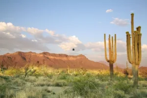
The Mojave Desert is the transitional, high-elevation heart of the American Southwest. Framed by fault-block mountains and broad basins, it stretches across nearly 124,000 km² of arid lands between the Sierra Nevada and the Colorado Plateau. This is the only desert on Earth where Joshua trees (Yucca brevifolia) naturally define the landscape, signaling you’ve crossed into the Mojave’s unique ecological neighborhood. From salt-white playas and booming dunes to volcanic cinder cones and badlands, the Mojave’s geology reads like an open textbook on the Basin and Range Province.
Physical Features
Area: ~124,000 km²
Length: ~500–600 km (east–west, depending on boundary used)
Width: ~400 km (north–south)
Elevation: From −86 m at Badwater Basin (Death Valley) to >2,000 m on surrounding ranges; broad alluvial fans (bajadas), playas (e.g., Soda Lake), sand seas (Kelso Dunes), and young volcanic fields (Cima) define the terrain.
Climate & Precipitation
Temperature: Among the hottest places on Earth in summer; highs routinely exceed 45 °C in Death Valley. Winter nights commonly fall below 0 °C at higher elevations.
Precipitation: Typically 50–150 mm annually in low basins, higher on mountain flanks. A “bimodal” pattern brings winter Pacific systems and late-summer monsoon storms; evaporation rates are extreme, sustaining hyper-arid soils and salt flats.
Ecological Features
Ecozone: Nearctic (North American warm desert)
Biome: Desert scrub with cold-season influences (winter freezes)
Ecoregions: Mojave Basin and Range (EPA Level III); Mojave Desert ecoregion (WWF). Transitional edges grade into the Sonoran (Colorado Desert) to the south and the Great Basin to the north.
Flora & Fauna
Flora: Joshua tree woodlands, creosote bush (Larrea tridentata), white bursage (Ambrosia dumosa), blackbrush (Coleogyne ramosissima), Mojave yucca, cholla and beavertail cacti, ephemerals that burst after rare rains.
Fauna: Desert tortoise (Gopherus agassizii; threatened), desert bighorn sheep, kit foxes, coyotes, kangaroo rats, chuckwallas, sidewinder and Mojave rattlesnakes, roadrunners, golden eagles, and specialized sand dwellers like the Mojave fringe-toed lizard.
Geology & Notable Features
Geology: Classic Basin and Range extension has produced tilted fault-block mountains, graben basins, active faults, and extensive alluvial fans. Aeolian processes build star and crescentic dunes (Kelso), while Quaternary volcanism left cinder cones and lava flows (Cima field). Evaporite playas record ancient lake cycles.
Notable Features: Death Valley National Park (Badwater Basin, Zabriskie Point), Mojave National Preserve (Kelso Dunes, Cima Dome), Joshua Tree National Park (ecotone with Colorado Desert), Red Rock Canyon (Nevada), Ash Meadows/Devils Hole (endemic pupfish), Mountain Pass rare-earth mine, historic borax operations, and utility-scale solar fields (e.g., Ivanpah).
Human Footprint & Conservation
Indigenous nations have stewarded Mojave lands for millennia, adapting to scarce water and seasonal resources. Modern pressures include groundwater extraction, mining, off-highway travel, invasive grasses, and climate-driven fire. Large protected areas now anchor connectivity for wide-ranging species and climate refugia. Restoration focuses on cryptobiotic soils, desert tortoise habitat, and post-fire Joshua tree recovery.
Visiting Responsibly
Travelers can experience salt pans, slot canyons, and high-desert forests in a single day—if they plan carefully. Carry ample water, check road conditions, and stay on designated routes to protect fragile desert crusts. Best seasons are late fall through early spring; summer heat is intense and dangerous.
Introduction
The Mojave Basin and Range is a geographic region in the southwestern United States. It is known for its desert landscapes, varied geology, and diverse plant and animal life. The region includes wide desert plains, rugged mountains, and a long cultural history, all of which reflect how desert ecosystems function.
Geography
The Mojave Desert is the primary desert within the larger Mojave Basin and Range province. Its geography is defined by a series of mountain ranges, basins, and valleys that create a stunning and diverse landscape. The major mountain ranges include the Sierra Nevada, San Bernardino Mountains, and Spring Mountains.
Spanning across several states—including California, Nevada, Utah, and Arizona—the Mojave Desert encompasses larger and more varied geographic features than many other deserts. Below is a detailed table that outlines various geographic features of the Mojave Basin and Range compared to other major deserts.
Geographic Features Comparison
| Feature | Mojave Desert | Sonoran Desert | Chihuahuan Desert |
|---|---|---|---|
| Area (Square Miles) | 25,000 | 100,000 | 140,000 |
| Elevation Range (Feet) | 800 to 11,000 | 0 to 9,000 | 3,000 to 8,000 |
| Temperature (Summer Avg) | 95°F | 104°F | 90°F |
| Rainfall (Inches per Year) | 3 to 5 | 5 to 15 | 8 to 20 |
Climate
The climate of the Mojave Basin and Range is classified as arid, characterized by low precipitation and high evaporation rates. The average annual rainfall is between 3 to 5 inches, making water resources scarce. Summers are particularly harsh, with average high temperatures often exceeding 100°F. Winters, however, can be mild, with cooler temperatures ranging from 30°F to 60°F, allowing for a unique climate variation.
Biodiversity
The Mojave Basin and Range is home to an impressive array of flora and fauna, specifically adapted to survive in this extreme environment. Vegetation types include creosote bush, Joshua trees, and various cacti species, exhibiting unique adaptations for water conservation. The diverse wildlife includes desert tortoises, Bighorn sheep, and several species of rodents and reptiles.
Conservation Efforts
Conservation efforts in the Mojave Basin and Range focus on protecting endangered species and their habitats. National parks and protected areas, including Death Valley National Park and Mojave National Preserve, play a key role in this work. These measures help protect biodiversity and support the long-term survival of species in the desert.
Cultural Significance
The Mojave Basin and Range region is known for both its natural features and its cultural history. Various Indigenous groups, including the Southern Paiute and Chemehuevi, have long lived in the area, developing traditions suited to desert life. The Mojave Desert has also supported mining activities and the growth of modern towns, shaping the region’s economy and settlement patterns.
Conclusion
The Mojave Basin and Range brings together distinct geology, climate patterns, biodiversity, and cultural history. The region shows how life adapts to arid conditions and why conservation work matters. The Mojave Desert reflects both the harsh conditions and the ecological diversity found in desert ecosystems.
References
Government / Official Sources
- U.S. National Park Service — Death Valley National Park (climate, geology, ecology)
- U.S. National Park Service — Mojave National Preserve (Kelso Dunes, Cima volcanic field)
- U.S. Bureau of Land Management — California Desert District (lands & conservation)
- U.S. Geological Survey — Desert research & climate adaptation
- U.S. EPA — Mojave Basin and Range ecoregion (Level III)
University Sources
- University of Nevada, Las Vegas — Desert ecology & water research
- UC Riverside, Center for Conservation Biology — Desert conservation & species recovery
- Arizona State University — Global Drylands Center (dryland processes)