When people talk about the most famous deserts in the world, they usually mean the named deserts that show up again and again in maps, school geography, Earth science, wildlife writing, and climate discussions. This list follows that public meaning. It focuses on the best-known non-polar deserts, while also keeping one scientific point clear: a desert is defined by aridity, not by heat alone.
That matters because Antarctica and the Arctic are deserts too in strict climate terms. Still, when readers search for famous deserts, they usually want places like the Sahara, Gobi, Atacama, or Mojave. So this article stays with those widely recognized names and explains what sets each one apart in landform, climate, ecology, and human geography.
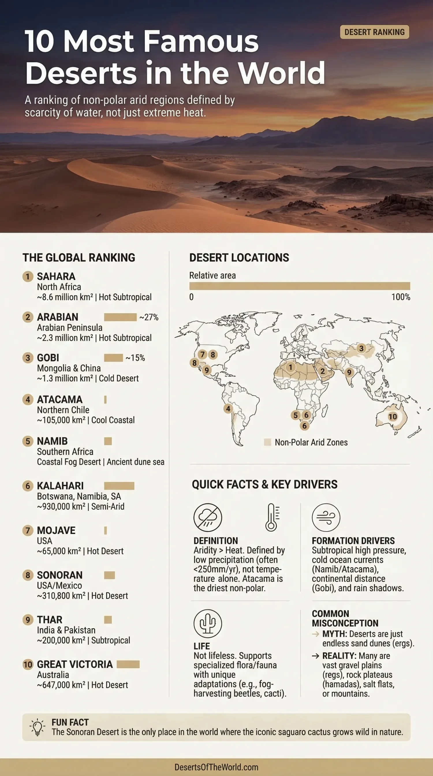
| Rank | Desert | Main Region | Approx. Area | Desert Type | What Makes It Widely Known |
|---|---|---|---|---|---|
| 1 | Sahara | North Africa | 8.6 million km² | Hot Subtropical Desert | Largest hot desert on Earth |
| 2 | Arabian | Arabian Peninsula | 2.3 million km² | Hot Subtropical Desert | Home of the Rubʿ al-Khali |
| 3 | Gobi | Mongolia and China | 1.3 million km² | Cold Desert | Extreme winter cold and rocky plains |
| 4 | Atacama | Northern Chile | About 105,000 km² | Cool Coastal Desert | One of the driest non-polar deserts |
| 5 | Namib | Namibia, Angola, South Africa | About 1,900 km long | Coastal Fog Desert | Ancient dune sea and fog-fed ecology |
| 6 | Kalahari | Botswana, Namibia, South Africa | 930,000 km² | Semi-Arid Desert | Red sands and wildlife-rich dry basin |
| 7 | Mojave | United States | 65,000 km² | Hot Desert | Death Valley and Joshua trees |
| 8 | Sonoran | United States and Mexico | 310,800 km² | Hot Desert | Wild saguaro cactus range |
| 9 | Thar | India and Pakistan | 200,000 km² | Subtropical Desert | Dense human settlement and monsoon edge climate |
| 10 | Great Victoria | Australia | 647,000 km² | Hot Desert | Australia’s largest desert |
What Counts as a Desert, and Why That Matters Here
A true desert climate is marked by very low precipitation, high evaporation, sparse plant cover, and wide temperature swings. Many geography references use 250 millimetres of mean annual precipitation as a rough upper line for a true desert, though some dry regions above that level are still treated as semi-desert because evaporation is so strong.
That is why this list is not only about sand seas. A desert can be rocky, gravel-covered, salt-flat based, or even fog-fed. The Gobi is famous for bare rock and gravel plains. The Namib is tied to coastal fog. The Atacama stays dry because of both the cold ocean current offshore and the Andes blocking moisture from the east. Different mechanics, same dry outcome.
The 10 Most Famous Deserts in the World
1. Sahara Desert
The Sahara Desert is the name most people picture first, and for good reason. It covers about 8.6 million square kilometres across North Africa, which makes it the largest hot desert on Earth. Its average precipitation is often around 76 to 127 millimetres a year, and some zones are even drier. Daytime heat can rise to about 50°C.
The Sahara is not one single sea of dunes. That image is too narrow. Large parts are made of gravel plains, rock plateaus, mountain massifs, dry valleys, and salt flats. The sandy sectors are called ergs, and they are only one part of the larger land system.
This desert is also famous for its dust transport. Saharan dust crosses the Atlantic and affects skies, soils, and ocean-atmosphere systems far beyond Africa. In plain terms, the Sahara is not just big; it is climatically active on a continental scale.
- Approximate Area: 8.6 million km²
- Average Rainfall: About 3 to 5 inches per year in many areas
- Known For: Largest hot desert, ergs, regs, hamadas, trans-Atlantic dust plumes
- Geographic Note: Extends across Morocco, Algeria, Tunisia, Libya, Egypt, Mauritania, Mali, Niger, Chad, and Sudan
2. Arabian Desert
The Arabian Desert spreads across almost the entire Arabian Peninsula and covers roughly 2.3 million square kilometres. It is the largest desert in Asia and one of the best-known hot deserts on Earth. Summer heat can reach about 54°C in parts of Arabia.
Its best-known sector is the Rubʿ al-Khali, or Empty Quarter, which is the largest area of continuous sand in the world, at roughly 650,000 square kilometres. That one figure explains a lot of the desert’s fame. Readers do not only remember the name; they remember the scale.
The Arabian Desert also shows how dry interiors work. There are wadis, gravel surfaces, sand sheets, and sabkhas. Water is scarce, yet localized oases and groundwater-fed pockets support settlement where conditions allow it. A huge dry body, but not a blank one.
- Approximate Area: 2.3 million km²
- Best-Known Subregion: Rubʿ al-Khali
- Known For: Vast dune fields, sabkhas, severe summer heat
- Geographic Note: Dominates Saudi Arabia and extends into Oman, Yemen, the UAE, Kuwait, Jordan, Iraq, and Qatar
3. Gobi Desert
The Gobi Desert breaks the old idea that every famous desert must be blistering hot and fully sandy. It covers about 1.3 million square kilometres across Mongolia and northern China, and it is one of the world’s best-known cold deserts. Winter lows can fall to around -40°C, while summer highs may climb to about 45°C.
Much of the Gobi is bare rock and gravel plain, not dune country. That detail gets missed on the first read by many people, yet it is central to the desert’s identity. The annual precipitation ranges from less than 50 millimetres in the west to more than 200 millimetres in the northeast, so dryness is real even where the surface does not look like a postcard dune field.
The Gobi is also well known in science because of its fossil beds, broad basins, and strong continental climate. It sits deep inland, far from ocean moisture, and the yearly temperature range is one of the clearest examples of a harsh continental desert system.
- Approximate Area: 1.3 million km²
- Temperature Range: About -40°C in winter to 45°C in summer
- Average Rainfall: Less than 50 mm in some western parts, over 200 mm in some northeastern parts
- Known For: Cold-desert climate, rocky terrain, fossil discoveries
4. Atacama Desert
The Atacama Desert in northern Chile is one of the driest non-polar deserts on Earth. It runs roughly 1,000 to 1,100 kilometres from north to south, and many estimates place its area at about 105,000 square kilometres. Some sectors receive heavy rain only two to four times in a century.
This desert is famous less for heat and more for extreme dryness. The cold Humboldt Current lowers evaporation near the coast, while the Andes help block moist air from the east. The result is a cool coastal desert where fog and cloud can appear without much rain reaching the ground.
The Atacama also has a strong technical side. The Chajnantor Plateau, at about 5,000 metres above sea level, hosts the ALMA Observatory, one of the best-known astronomy sites on the planet. Dry air, thin atmosphere, and very low cloud cover make the region ideal for high-altitude observation. In desert science, few places are this usefull for both Earth studies and Mars analog research.
- Approximate Area: About 105,000 km²
- Length: About 1,000 to 1,100 km
- Known For: Hyper-arid core, astronomy, Mars analog studies, salt flats
- Technical Note: ALMA sits at roughly 5,000 m on the Chajnantor Plateau
5. Namib Desert
The Namib Desert is often described as one of the oldest deserts on Earth. It stretches for about 1,900 kilometres along the Atlantic coast of southern Africa and usually reaches 130 to 160 kilometres inland. It is famous for huge dune systems, open gravel plains, and a dry coastline shaped by the cold Benguela Current.
Its best-known ecological trait is fog. In the Namib Sand Sea, fog serves as the primary water source for many organisms. That single fact makes the Namib stand apart from many other deserts. It is also the only coastal desert in the world with extensive dune fields influenced by fog.
The dune fields around Sossusvlei have made the Namib instantly recognizable in global geography. Long linear dunes, star dunes, dry pans, and sharply lit ridges give it a landform signature few deserts can match. It is dry, yes, but also geomorphically very precise. Clean lines. Clear process. Little visual noise.
- Length: About 1,900 km
- Typical Inland Width: About 130 to 160 km
- Known For: Fog-fed life, giant dunes, coastal desert setting
- Scientific Note: The Namib Sand Sea is a UNESCO World Heritage site
6. Kalahari Desert
The Kalahari Desert covers about 930,000 square kilometres across Botswana, Namibia, and South Africa. It is widely known for its red sands, shallow basin shape, dry grasslands, and strong wildlife associations. Yet the Kalahari also reminds readers that not all deserts are bare and empty-looking.
Rainfall varies a lot across the basin. In the southwest it can fall below 125 millimetres a year, while parts of the northeast can receive more than 500 millimetres. Because of that range, the Kalahari is often treated as a semi-desert. That is not a weakness in the label; it is what makes the place geograpically useful for understanding desert margins.
Unlike the hyper-arid Atacama, the Kalahari supports more scrub, more grass, and broader wildlife movement. It shows what a desert looks like when water is scarce but not absent everywhere. The visual result is softer. The climatic message is still dry.
- Approximate Area: 930,000 km²
- Rainfall Range: Less than 125 mm in the south to more than 500 mm in the northeast
- Known For: Red sand, dry savanna character, wildlife-rich desert margins
- Landscape Note: Broad basin with dunes, scrub, and grassland patches
7. Mojave Desert
The Mojave Desert occupies more than 65,000 square kilometres in the southwestern United States. It is one of the most recognized deserts in North America, largely because of Death Valley, Joshua trees, and its strong place in film, road geography, and public land culture.
The climate is harsh even by desert standards. In Mojave National Preserve, annual precipitation ranges from about 3.5 inches at lower elevations to nearly 10 inches in the mountains. Nearby Death Valley holds the official world air-temperature record of 56.7°C, and average annual rainfall there is less than 2 inches.
This is also where Joshua trees help define a desert visually. The species is native to the Mojave, and if you see one on open dry ground, you are very likely in Mojave country or along its edge. The region is a classic mix of alluvial fans, basins, playas, and isolated ranges created by Basin and Range extension.
- Approximate Area: 65,000 km²
- Typical Rainfall: About 3.5 to 10 inches across Mojave National Preserve
- Known For: Death Valley, Joshua trees, basin-and-range landforms
- Technical Note: Death Valley holds the official 56.7°C air-temperature record
8. Sonoran Desert
The Sonoran Desert covers about 310,800 square kilometres across Arizona, California, Baja California, Baja California Sur, and Sonora. It is one of the best-known deserts in the Americas because it combines classic heat with high biodiversity, major elevation contrast, and the unmistakable profile of the saguaro cactus.
Annual precipitation averages from about 76 to 500 millimetres, depending on location and elevation. That is higher than many readers expect, which is why the Sonoran is often described as one of the wetter hot deserts. It also has two rainy seasons in many areas, one tied to winter systems and one tied to the summer monsoon.
The Sonoran Desert is the only place where the saguaro cactus grows in the wild. That one ecological marker gives the region a near-instant identity. It also helps explain why the Sonoran often feels more alive than textbook desert stereotypes suggest. More rain, more plant structure, more seasonal pulses. Still a desert, plainly so.
- Approximate Area: 310,800 km²
- Rainfall Range: 76 to 500 mm
- Known For: Saguaros, two rainy seasons, high species variety
- Biogeographic Note: Includes the Colorado and Yuma desert subdivisions
9. Thar Desert
The Thar Desert, also called the Great Indian Desert, covers about 200,000 square kilometres in northwestern India and southeastern Pakistan. It is famous not only for sand dunes and arid plains, but also for the way people have lived within a dry environment for a very long time.
Annual rainfall ranges from about 100 millimetres or less in the west to around 500 millimetres in the east, and roughly 90 percent of that rain falls during the southwest monsoon season from July to September. That makes the Thar a desert strongly tied to monsoon margins, not just subtropical dryness alone.
The Thar stands out because it is one of the world’s most densely settled desert regions. Villages, grazing, irrigated belts, salt lakes, sandy plains, and low rocky rises all exist in a tight human-environment relationship. It is a desert, yes, but also a lived-in landscape rather than a remote empty one.
- Approximate Area: 200,000 km²
- Rainfall Range: About 100 to 500 mm
- Known For: Monsoon-edge climate, dunes, saline lakes, dense settlement
- Regional Note: Lies mainly in Rajasthan, with extensions into Pakistan
10. Great Victoria Desert
The Great Victoria Desert is Australia’s largest desert. It covers about 647,000 square kilometres across Western Australia and South Australia. On global lists it is sometimes placed lower than the Sahara or Gobi in public recognition, yet it remains one of the most famous named deserts because it anchors the Australian desert image in world geography.
Most years it receives about 150 to 250 millimetres of rain. By global desert standards that may look a little high, but the heat, high evaporation, and sparse vegetation keep conditions distinctly arid. Spinifex grass, low shrubs, pebble plains, sand ridges, and salt lakes shape much of the surface.
The Great Victoria matters because it helps balance the usual desert conversation. Many global lists lean too hard on Africa, Asia, and the Americas. Australia belongs in the picture, and this desert is the clearest place to put it. Broad, dry, and often understated, it carries the Australian desert form very well.
- Approximate Area: 647,000 km²
- Average Rainfall: About 150 to 250 mm
- Known For: Australia’s largest desert, spinifex plains, long sand ridges
- Landscape Note: Sandhills, gibber-like stony areas, and salt lakes occur together
Why These Deserts Stay So Well Known
These deserts are famous for different reasons, and that is worth saying plainly. Some are known for size, like the Sahara and Arabian. Some are known for climate extremes, like the Gobi, Atacama, and Mojave. Some are tied to very clear biological symbols, like the saguaro in the Sonoran or the fog-adapted life of the Namib. Others stand out because dryland living is part of the story, as in the Thar.
Together they also show the main engines behind desert formation:
- Subtropical High-Pressure Belts: A big reason for the Sahara and Arabian Desert
- Cold Ocean Currents: Central to the Namib and Atacama
- Continental Interior Dryness: A major part of the Gobi story
- Rain Shadow Effects: Strong in desert basins near mountain chains
- Monsoon Margins: Easy to see in the Thar
- High Evaporation: The hidden number that makes many semi-dry places behave like deserts
That is also why “desert” should never be treated as one visual category. Some deserts are ergs with moving dunes. Some are regs of gravel. Some include playas, sabkhas, inselbergs, alluvial fans, and ephemeral rivers. Some even depend on fog more than rain. Same climate family, very different landscapes.
Sources
- https://www.britannica.com/place/Sahara-desert-Africa (Sahara size, extent, and general geography)
- https://www.britannica.com/place/Sahara-desert-Africa/Climate (Sahara precipitation and climate notes)
- https://science.nasa.gov/earth/earth-observatory/satellites-see-saharan-dust-from-space/ (Saharan dust movement over the Atlantic)
- https://www.britannica.com/place/Arabian-Desert (Arabian Desert area and regional extent)
- https://www.britannica.com/place/Rub-al-Khali (Rubʿ al-Khali as the world’s largest continuous sand area)
- https://www.britannica.com/place/Gobi (Gobi area, landform, and geography)
- https://www.britannica.com/place/Gobi/Climate (Gobi rainfall and temperature range)
- https://www.britannica.com/place/Atacama-Desert (Atacama dryness, length, and coastal climate)
- https://www.eso.org/sci/facilities/alma.html (ALMA location and high-altitude Atacama astronomy setting)
- https://whc.unesco.org/en/list/1430/ (Namib Sand Sea, fog-fed coastal dune system)
- https://www.britannica.com/place/Namib (Namib length, width, and general geography)
- https://www.britannica.com/place/Kalahari-Desert (Kalahari setting and extent)
- https://www.britannica.com/place/Kalahari-Desert/Climate (Kalahari rainfall gradient)
- https://www.nps.gov/moja/planyourvisit/weather.htm (Mojave rainfall and weather range)
- https://www.nps.gov/deva/learn/nature/weather-and-climate.htm (Death Valley temperature and rainfall data)
- https://www.nps.gov/jotr/learn/nature/jtrees.htm (Joshua tree range in the Mojave)
- https://www.britannica.com/place/Sonoran-Desert (Sonoran Desert area and extent)
- https://www.nps.gov/im/sodn/climate.htm (Sonoran Desert precipitation data)
- https://www.nps.gov/sagu/learn/nature/saguaro.htm (Saguaro cactus range in the Sonoran Desert)
- https://www.britannica.com/place/Thar-Desert (Thar area, rainfall, and monsoon pattern)
- https://www.britannica.com/place/Great-Victoria-Desert (Great Victoria Desert location and extent)
- https://kids.britannica.com/students/article/Great-Victoria-Desert/325138 (Great Victoria Desert rainfall and area figures)