A desert is defined by dryness, not by heat. That single idea changes how cold arid lands are seen. Many readers picture dunes under a blazing sun, yet a large share of the planet’s drylands sit in high basins, rain-shadow plateaus, continental interiors, and winter-cold steppes where frost, snow, and sharp temperature swings shape the ground as much as wind does. In these places, water stays scarce even when winter is harsh. That is what makes a cold desert a desert.
Black Rock Desert
Location & Continent Continent: North America Country: United States State: Nevada Counties: Washoe, Pershing, Humboldt Region: Great Basin...
Read More →Tengger Desert
Location & Continent Continent: Asia Country: China Primary Regions: Inner Mongolia (Alxa League), Ningxia, Gansu Approximate Coordinates (Center...
Read More →Hami Desert
Location & Continent Continent: Asia Region: Eastern Xinjiang, northwestern China Desert System: Gobi Desert (often described as the...
Read More →Badain Jaran Desert
Location & Continent Continent: Asia Country: China Region: Alxa Plateau, Inner Mongolia Autonomous Region (with edges reaching toward...
Read More →Mu Us Desert
Location and Regional Context The Mu Us Desert (often described as the Mu Us Sandy Land) sits in...
Read More →Kubuqi Desert
Location & Continent Continent: Asia Country: China Region: Inner Mongolia Autonomous Region (Ordos area) Broader Setting: The Kubuqi...
Read More →Patagonian Desert
Location & Continent Continent: South America Countries: Mainly Argentina, with smaller steppe areas extending into Chilean Patagonia Region:...
Read More →Monte Desert
Location & Continent Continent: South America Country: Argentina Region: Eastern foothills of the Andes, from northern–central Argentina to...
Read More →Snake River Plain
Location & Continent Continent: North America Country: United States (primarily Idaho, reaching toward eastern Oregon and western Wyoming)...
Read More →Arizona/New Mexico Plateau
Location & Continent Continent: North America Country: United States (Arizona & New Mexico) Coordinates: ~35°N, 109°W Arizona/New Mexico...
Read More →Colorado Plateaus
Location & Continent Continent: North America Country: United States (Arizona, Utah, Colorado, New Mexico) Coordinates: ~36°N, 111°W Colorado...
Read More →Central Basin and Range (Great Basin Desert)
Location & Continent Continent: North America Country: United States (Nevada, Utah, California, Oregon, Idaho) Coordinates: ~39.5°N, 116°W (regional...
Read More →Wyoming Basin
Location & Continent Continent: North America Country: United States (primarily Wyoming; edges into CO/UT/ID/MT within the broader ecoregion)...
Read More →Northern Basin and Range
Location & Continent Continent: North America Country: United States (Oregon, Idaho, Nevada, Utah, California) Coordinates: 43°N, 117°W Northern...
Read More →Columbia Basin
Location & Continent Continent: North America Country: United States (Washington, Oregon, and a small portion of Idaho) Coordinates:...
Read More →Thompson-Okanagan Plateau Desert
Location & Continent Despite its name, the “Okanagan Desert” is not a true desert by scientific definition. Annual...
Read More →Taklamakan Desert
An immense sea of sand in China’s Xinjiang Uyghur Autonomous Region, the Taklamakan is one of Earth’s largest...
Read More →Gurbantünggüt Desert
Location & Continent Continent: Asia Country: China (Xinjiang Uyghur Autonomous Region) Coordinates: 45°N, 86°E Gurbantünggüt Desert – Map...
Read More →Kumtag Desert
Location & Continent Continent: Asia Country: China (Xinjiang Uyghur Autonomous Region) Coordinates: 40°N, 91°E Kumtag Desert – Map...
Read More →Ordos Desert
Location & Continent Continent: Asia Countries: China (Inner Mongolia Autonomous Region) Coordinates: 39°N, 108°E Ordos Desert – Map...
Read More →Lop Desert
Location & Continent Continent: Asia Countries: China (Xinjiang Uyghur Autonomous Region) Coordinates: 40°N, 90°E Lop Desert – Map...
Read More →Karakum Desert
Location & Continent Continent: Asia Countries: Turkmenistan (mainly), with smaller portions extending into Uzbekistan and Kazakhstan Coordinates: 39°N,...
Read More →Kyzyl Kum
Location & Continent Continent: Asia Countries: Uzbekistan, Kazakhstan, Turkmenistan Coordinates: 41°N, 64°E Kyzyl Kum – Map & Street...
Read More →Gobi Desert
Location & Continent Continent: Asia Countries: China, Mongolia Coordinates: 42°N, 105°E Gobi Desert – Map & Street View...
Read More →Katpana Desert
Location & Continent Continent: Asia Country / Region: Pakistan — Gilgit-Baltistan (Skardu District) Coordinates: 35.3105°N, 75.5907°E Katpana Desert...
Read More →Monegros Desert
Location & Continent Continent: Europe Country: Spain (Aragón region, between Zaragoza and Huesca provinces) Coordinates: 41°30′N, 0°15′W Map...
Read More →Oleshky Sands (Oleshky Desert)
Location & Continent Continent: Europe/Asia (Ukraine) Country: Ukraine Coordinates: 46°37′N 34°57′E Map previewClick to load the interactive map...
Read More →Tabernas Desert
Location & Continent Continent: Europe Countries: Spain Coordinates: 37°N, 2°W Map previewClick to load the interactive map Load...
Read More →Bardenas Reales
Location & Continent Continent: Europe Country: Spain Region: Southeast of Navarre, near Tudela Coordinates: 42°06′N, 1°30′W Map previewClick...
Read More →29 inventions in Cold Deserts
Across the non-polar world, cold deserts stretch from the Great Basin of North America to the Gobi-Taklamakan belt of inner Asia, from the Patagonian rain shadow in southern South America to the semi-arid interiors of Spain and the sandy lowlands near the lower Dnipro. Some are true BWk deserts in Köppen climate terms. Others sit on the border between cold desert and cold semi-arid steppe and are better described as cold arid regions. That distinction matters. It also explains why one list of cold deserts never looks exactly like the next.
One point should stay clear: the largest cold deserts on Earth are the polar deserts of Antarctica and the Arctic, where precipitation is extremely low and much of the surface is locked in ice. This page centers on non-polar cold arid regions with exposed soils, gravel plains, badlands, sandy basins, and plateau landscapes, because those are the landscapes most readers mean when they search for cold deserts and land-based arid regions.
Cold deserts do not all look alike. One can be a salt playa. Another can be a stony basin with sagebrush and winter snow. Another may hold megadunes a few hundred meters high. Another looks more like a badland carved by runoff than a sea of sand. Some have less than 50 mm of annual precipitation in their driest cores. Others sit closer to 250 to 400 mm and still behave like deserts because evaporation demand stays far above precipitation. Dry it is, but never simple.
What Makes a Desert Cold
A cold desert is an arid region where winters are cold enough for frequent frost, regular subfreezing nights, or seasonal snow, and where total precipitation stays low. A common working threshold for a true desert is under about 250 mm of mean annual precipitation, though exact limits vary by climate system and by how evapotranspiration is treated. In plain language, a cold desert is a place where water is scarce year round, even if winter temperatures are low and even if a little snow falls.
The best technical shorthand is the BWk climate type in the Köppen system: B for dry climate, W for desert, and k for cold annual temperature regime. On the margins, many cold arid regions fall into BSk, the cold semi-arid or steppe class. This is why lists often mix true cold deserts with cold semi-deserts. The landscape logic is the same: sparse moisture, strong continentality, open ground, and vegetation that must endure drought, wind, and winter cold all at once.
Popular writing often treats cold deserts as “deserts, but colder.” That misses a lot. In a hot subtropical desert, the story is often about descending dry air, summer heat, and bare rock or sand. In a cold desert, the story usually adds elevation, distance from oceans, winter snow with low water yield, closed-drainage basins, and large seasonal temperature range. Snow may fall, but the annual total is still tiny. Melt may come, but it often vanishes fast through infiltration, runoff pulses, or evaporation. Cold desert weather recieves little help from humidity.
Aridity First
Deserts are dry because precipitation stays too low for dense vegetation and sustained surface water.
Winter Cold Matters
Cold deserts usually have frost, snow, or subfreezing periods that shape soils, surface crusts, and plant growth.
Evaporation Still Wins
Even where winters are cold, the yearly water balance stays dry because evapotranspiration demand exceeds moisture supply.
Margins Are Real
Many famous cold-desert landscapes sit in the BSk to BWk transition, especially on plateaus and basin rims.
A second misconception is that cold deserts must be snowy landscapes. Many are not. The Gobi can see frost and snow, yet large areas remain mostly stony and dry. The Taklamakan is colder in winter than many readers expect, yet it is also one of the planet’s great sand deserts. The Great Basin gets winter snow on basin rims and mountains, but valley floors stay dry enough to support salt flats, sagebrush plains, and bare playas. So barren they can look, yet the climate mechanics behind them are finely tuned.
Because searchers often want a clean list, it helps to separate cold deserts into three broad groups: core cold deserts with clear BWk traits; cold semi-arid desert margins that look and function like desert landscapes even when annual precipitation is slightly higher; and cold badland or sandy regions that are not always strict climatic deserts but belong to the same dryland story. The regions on this page span all three.
Why Cold Deserts Form
Rain Shadows Build Dry Interiors
The most common cold-desert engine is the rain shadow. Moist air rises over mountain barriers, cools, and drops much of its moisture on the windward side. By the time the air descends into inland basins, it warms and dries. This process helps explain the Great Basin behind the Sierra Nevada, the Patagonian Desert east of the Andes, and the huge dry interiors of western China where the Himalaya, Kunlun, Tianshan, Altun, and other ranges limit incoming moisture. When those barriers line up across a continent, aridity can become severe.
That is why many cold deserts sit in broad intermontane basins. Water from surrounding highlands may reach basin floors only as brief runoff pulses, alluvial fans, or ephemeral rivers. Most of it never reaches the sea. Instead, it ends in playas, saline lakes, or underground storage. Closed drainage is a cold-desert signature worth noticing, because it controls salt buildup, fine sediment transport, and the formation of the pale flat floors many basins are known for.
Continental Distance Makes Winters Harsh
The second driver is continentality. Far from oceans, seasonal temperature ranges widen. Winters turn colder. Air stays dry. Daily temperature range can also grow because clear skies allow strong daytime heating and rapid night cooling. The Gobi Desert shows this clearly: parts of it can drop below −40°C in winter and climb above 40°C in summer. That kind of swing is not a side note. It affects soil cracking, frost action, dune surface stability, and the short seasonal window when plants can grow.
Cold desert does not mean cold all year. It means a dry region with a marked cold season. Summer can still be hot, especially on exposed basin floors. That is why many cold deserts feel like lands of extremes rather than lands of constant cold. In the same place, one can find snow patches in winter, dust storms in spring, and surface temperatures that soar in summer. The dryness stays constant; the temperature does not.
High Elevation Turns Drylands Into Cold Drylands
Altitude is the third main control. High basins and plateaus lose heat quickly, and higher air masses hold less moisture. The result can be a landscape with desert-level dryness but colder mean temperatures than lowland deserts. The Great Basin is often called the United States’ cold desert because many of its valleys sit above 1,200 m. The Katpana Desert in Pakistan is even more striking: a high-elevation sandy desert where winter snow can lie over dunes. It looks almost contradictory. It is not.
Elevation also shapes snow behavior. Cold deserts may receive some winter snow, but totals are often modest and meltwater is short-lived. Much of the moisture never becomes long-lasting surface water. It either runs off quickly, infiltrates coarse sediments, evaporates, or freezes into shallow soils that only thaw for a brief growing period. This is one reason why snow does not cancel aridity. A cold desert can look seasonally white and still be one of the driest places in its region.
Dust, Wind, and Basin Geometry Do the Rest
Once a region is dry, cold, and open, wind becomes a major sculptor. Fine sediments move off dry lakebeds and alluvial fans. Coarser grains pile into dunes. Repeated deflation can leave behind desert pavement, a surface of closely packed stones that protects finer material below. Elsewhere, wind cuts yardangs, long ridges streamlined by abrasion. In closed basins, salts accumulate as evaporation outpaces inflow. These are not decorative details. They are how cold desert surfaces record climate over time.
Many cold deserts are also geomorphic archives. A playa can preserve traces of former lakes. A dune field can show changes in wind regime, vegetation cover, or moisture availability. A badland slope can reveal alternating layers of clay, gypsum, or sandstone. In other words, cold deserts do not merely reflect modern climate; they also keep a long memory of wetter phases, shrinking lakes, and shifting sand. That memory is often visible on the ground.
How Cold Desert Landscapes Differ on the Ground
Sandy Seas, Gravel Plains, and Stone Deserts
Not every cold desert is a dune sea. The Taklamakan and Badain Jaran are famous for sand, but the Gobi is widely known for gravel plains, rocky surfaces, and broad stony basins. In the Great Basin, many valley floors are not classic dunes at all; they are playas, salt flats, or shrub-steppe plains. This matters because surface type controls everything from runoff to soil temperature to plant rooting depth.
Ergs, or sand seas, form where enough sand is available and winds can sort and move it. In cold deserts, these sand bodies may be bordered by mountains, fed by dry river systems, or linked to former lake basins. Regs and gibber plains, by contrast, are coarser, stonier, and often more stable at the surface. A traveler who expects only dunes will miss half the story. Cold arid regions are often mosaics of sand, gravel, clay, salt, and bedrock.
Playas and Salt Basins Are a Cold Desert Signature
One of the most useful clues in a cold desert is the presence of a playa or temporary lake floor. These flat basins collect runoff from surrounding highlands, then dry out and leave behind silts, clays, and salts. In the Great Basin, this process is tied to the legacy of former pluvial lakes such as Lake Lahontan. The Black Rock Desert, for example, is not just a dry flat; it is part of a much older closed-basin history where wetter climatic periods once supported larger lake systems.
Playas also change seasonally. A basin may be crusted and hard in late summer, sticky after rainfall, and shallowly flooded in late winter or spring. That shifting surface matters for dust generation, vehicle access, bird use, and salt chemistry. The same dry floor that looks empty on one visit may hold water, fairy shrimp, or thin reflective sheets the next. Cold deserts are often dynamic in pulses rather than in steady flow.
Badlands Show How Rare Rain Can Shape Dry Ground Fast
When rare rain falls on sparse vegetation and weak sediment, erosion can be fierce. That is how badland topography forms: gullies, rills, tabular remnants, isolated towers, and steep crumbly slopes. Spain’s Tabernas Desert and Bardenas Reales show this beautifully, but badland logic also appears in parts of the Colorado Plateau and in basin margins across the cold arid belt. A place can receive little annual rainfall and still be deeply carved because the few storms that do arrive hit hard.
This point is often skipped in generic desert writing. Low annual rainfall does not mean low erosive power. In cold arid regions, storm intensity, bare ground, slope angle, and fine-textured sediment can produce fast runoff and sharp incision. One storm can redraw channels. One wet season can activate a whole network of gullies. Sparse rain, yes. Mild geomorphic change, not always.
Soils Are Thin, Salty, Crusted, or Surprisingly Fertile in Patches
Cold desert soils vary more than the surface suggests. Some are alkaline and rich in salts. Some hold gypsum. Some develop carbonate horizons or caliche. Some coarse alluvial fans drain so fast that roots struggle to access water between storms. Yet around basin margins, river corridors, springs, or loess-covered benches, soils may support grassland, shrubs, or even irrigated agriculture once water is added. That contrast between barren flats and productive edges is classic cold-desert geography.
Biological soil crusts may also appear where disturbance stays low. These crusts, built by lichens, mosses, cyanobacteria, and fungi, help hold sediment in place and influence infiltration. They are easily broken. Once disturbed, wind erosion can rise sharply, especially on fine-textured surfaces. A cold desert surface can look tough and still be fragile.
Plants and Animals in Cold Arid Regions
Cold desert life solves a difficult equation: little water, large temperature swings, short growing seasons, and often salty or nutrient-poor soils. Plants stay low, small-leaved, deep-rooted, or seasonally opportunistic. Many species use narrow timing windows after snowmelt or rare rain. Others avoid exposure with cushion forms, waxy leaves, or dormancy. Shrublands built around sagebrush, saltbush, wormwood, ephedra, halophytes, and drought-tolerant grasses are common across mid-latitude cold deserts.
Animal life often follows the same rules: reduce water loss, avoid midday exposure, use burrows, move seasonally, and take advantage of patchy productivity. Large herbivores tend to track better-forage margins, ephemeral green-up, or river corridors. Smaller mammals and reptiles use microhabitats with moderated temperatures. Birds take advantage of wetlands when playa basins hold water. That mix can make cold deserts look empty from far away and ecologically busy up close.
What is striking is not abundance in the tropical sense, but efficiency. Cold desert ecosystems waste very little. Nutrients cycle slowly. Biomass stays modest. Disturbance can linger for years because recovery is slow. In a wet forest, one damaged patch may heal quickly. In a cold desert, the same footprint may remain visible much longer. Sparse ecosystems are not weak ecosystems. They are just working on tighter margins.
North America’s Cold Desert Belt
North America’s cold arid core sits in the interior West, especially across the Great Basin and its neighboring plateaus. Here, altitude, closed drainage, rain shadow, and winter cold combine to create the continent’s clearest non-polar cold-desert landscapes. Some areas are textbook desert. Others are better described as semi-arid shrub-steppe or cold desert margin. On the ground, though, they connect as one broad dry system.
Great Basin Core, Playas, and Basin Floors
The linked terrain of the Central Basin and Range forms the heart of the Great Basin cold-desert story. Much of this region lies above 1,200 m, and many valleys receive only about 150 to 300 mm of annual precipitation. Snow falls on the surrounding ranges and sometimes on valley floors, yet the yearly water balance stays dry. What defines the region is not one dune field or one lakebed, but the repeated pattern of parallel mountain ranges, arid basins, alluvial fans, and closed sinks.
Within that setting, the Black Rock Desert stands out as one of the clearest examples of a playa-centered cold desert. Its famous flat surface is the dry remnant of a larger pluvial lake system tied to ancient Lake Lahontan. Annual precipitation in the playa zone is low, around 170 to 200 mm in nearby records, and seasonal flooding can briefly turn parts of the basin into shallow water. Then it dries, hardens, cracks, and sends fine sediment back into the wind cycle. A cold desert can be almost perfectly flat. Black Rock proves it.
The Northern Basin and Range continues the same logic farther north, though with somewhat cooler conditions and strong variation between mountain blocks and basin floors. Many valleys stay under about 380 mm of annual precipitation, with drier sectors closer to 200 to 300 mm. Sagebrush, greasewood, salt flats, and volcanic tablelands all appear. It reads less like a single desert and more like a chain of dry bowls separated by ridges. That patchwork is exactly what a basin-and-range cold desert should look like.
The Wyoming Basin sits higher, cooler, and more steppe-like in many places, but it belongs in the same conversation because of its dry shrublands, broad basins, and cold winter regime. Much of the basin lies in a cold semi-arid zone, with shrub-steppe and salt desert scrub rather than classic dune landscapes. The important point is not whether every square kilometer meets a strict desert threshold. It is that the region behaves as a cold arid interior basin shaped by limited moisture and strong seasonality.
Lava Plains, Plateaus, and Shrub-Steppes
The Snake River Plain shows another face of cold aridity. Instead of a closed-basin mosaic, much of this region is a broad volcanic plain with lava fields, sagebrush, and semiarid climate. Mean annual precipitation across the wider ecoregion spans a broad range, but many lower and central sectors sit near 150 to 300 mm, enough to stay open and dry, yet not always enough to count as a strict desert everywhere. That mixed status is useful, not confusing. It shows how cold-desert geography shades gradually into shrub-steppe.
Farther west, the Columbia Basin adds a different pattern again: basalt plateaus, loess, coulees, scablands, and some of the driest interior lowlands in the Pacific Northwest. Driest parts of the basin receive only around 180 to 250 mm annually, though other sectors are wetter. The rain shadow here comes largely from the Cascades, and the result is a region where bunchgrass, sagebrush, dryland farming, and irrigated agriculture meet. This is cold-desert logic expressed through plateau country rather than through giant dune seas.
Southwestern Plateaus and High Desert Country
The Arizona/New Mexico Plateau occupies a transitional belt between warmer southwestern deserts and the higher, cooler tablelands of the interior West. Much of the region is semi-arid, with many areas receiving about 150 to 250 mm annually, though local totals vary a lot with elevation and monsoon exposure. Winter cold, open shrubland, grass-shrub mixes, and broad mesas place it inside the cold-arid story, even if not every part reads as true desert.
The Colorado Plateaus are similar: a wide high-desert country of mesas, canyons, buttes, pinyon-juniper woodlands, sparse grasslands, and arid basins. Annual precipitation across the ecoregion often falls in the 150 to 400 mm range, with driest zones in lower basins and wetter totals on uplands. What makes the plateaus important in a cold desert guide is not pure climatic severity, but the way elevation, winter cold, rock exposure, and sparse moisture combine to create one of the planet’s clearest high-desert landscapes.
Canada’s Dry Interior Margin
The Thompson-Okanagan Plateau Desert is a good example of why labels matter. The southern Okanagan is often called a desert, but scientifically much of it is better described as semi-arid shrub-steppe. Valley floors near Osoyoos receive roughly 320 mm of precipitation, which is dry by Canadian standards but usually above the classic true-desert threshold. Still, the region clearly belongs in a page on cold arid regions because it combines rain-shadow dryness, hot dry summers, cool winters, sagebrush habitats, and a distinctly desert-like appearance in its driest lowlands.
That “not always a true desert, yet fully part of the dryland picture” status is worth remembering. It helps explain why searchers encounter competing answers when they ask where Canada’s desert is. The better answer is that the Thompson-Okanagan contains one of Canada’s clearest cold semi-arid desert-like landscapes, especially in the driest valley bottoms. The science becomes clearer once the strict desert vs. cold-arid margin distinction is kept in view.
Asia’s Great Cold Desert Arc
No continent expresses non-polar cold-desert geography more fully than Asia. From Mongolia and northern China across Xinjiang and into Central Asia, cold arid regions form a massive interior belt shaped by distance from oceans, high mountain barriers, closed basins, and continental winter cold. This belt includes some of the planet’s driest, windiest, and most dramatic sand and gravel deserts.
The Gobi System and Its Margins
The Gobi Desert is the best-known cold desert in the public imagination, and for good reason. It spans a vast area across Mongolia and northern China, receives less than 50 mm in some western parts and more than 200 mm in some northeastern margins, and swings from severe winter cold to very hot summer days. Average lows in the cold season can drop toward −40°C in some sectors, while summer highs may rise to about 45°C. Those numbers alone explain why the Gobi became shorthand for cold-desert climate.
Still, the Gobi is not one uniform sand sea. Much of it is stony, gravelly, or rocky, with wide basins, low mountain blocks, dry washes, and steppe-desert transitions. That surface diversity is one reason the Gobi matters so much in desert science. It breaks the old stereotype that deserts are always sandy. A great many are not.
On the southeastern and eastern margins of the broader Gobi system lies the Ordos Desert, a dry region of northern China often treated as a composite desert zone that includes sandy sectors and loess-influenced margins. It acts as a bridge between core aridity and semiarid steppe. In climatic terms, it is more mixed than the driest Gobi basins, but geomorphically it belongs in the same family of inland cold drylands.
Within that larger Ordos setting, the Mu Us Desert is especially interesting because it sits close to the desert-steppe threshold. Annual precipitation can range from about 250 mm in drier western parts to roughly 440 mm in wetter sectors, which is high for a desert but still low enough, with strong evapotranspiration and land-use pressure, to support sand movement and desert-like terrain. Mu Us is a reminder that many cold deserts are not fixed by rainfall alone. Vegetation cover, wind, groundwater depth, and disturbance matter too.
The Kubuqi Desert, also in Inner Mongolia, occupies a similar desert-margin zone, though it is drier in many sectors than Mu Us and includes active and stabilized sands. Reported precipitation ranges often fall between about 200 and 480 mm depending on location and dataset. That wide spread tells its own story: Kubuqi is both a desert and a transition zone, which is why it appears so often in discussions of dune stabilization, restoration, and land management in cold arid northern China.
China’s Great Sandy Cold Deserts
The Badain Jaran Desert is one of Asia’s most remarkable sand deserts. Covering roughly 50,000 km², it is known for giant dunes that rise hundreds of meters and for interdune lakes that seem almost improbable in such an arid setting. Those lakes are part of what makes the desert famous: they hint at groundwater supply, basin hydrology, and local moisture pathways beneath a landscape that still receives very little rain. In climatic terms, Badain Jaran is cold and arid, with winter chill, strong winds, and sparse rainfall.
The Tengger Desert lies nearby and adds another major sandy region to the same northern China belt. It is often described as a continental desert with annual precipitation commonly around 100 to 200 mm, though local totals vary across its extent. Tengger is important not only for its dunes, but also for its role in dust generation, sand transport, and the long struggle between mobile sand and human settlement on nearby margins.
East of the core basins, the Hami Desert occupies the dry eastern Xinjiang region and connects the Gobi realm with the basin deserts farther west. Hami is not usually the first name readers think of, yet it deserves attention because it sits in one of the clearest continental arid corridors in China. Basin-floor precipitation in the wider Hami area is often under 50 mm annually, while evaporation is far higher. That combination produces a stark dryland where desert dominates the ecological map.
The Tarim and Junggar Basins
The Taklamakan Desert is one of Earth’s great sand deserts and one of the clearest true cold deserts outside the polar world. It occupies the Tarim Basin in Xinjiang and is bordered by some of Asia’s highest mountain systems. Because those mountains block moisture from multiple directions, the desert core is extremely dry. In the driest parts, annual precipitation may fall to around 10 to 38 mm. Winter temperatures can drop well below −20°C, while summer heat still pushes upward toward the upper 30s Celsius. Few landscapes show the cold-desert paradox more clearly than the Taklamakan.
The basin setting is the key. Rivers descending from surrounding mountains support oases on the margins, but the interior remains a vast sand body with shifting dunes, long transport corridors, and a climate that is dry almost beyond intuition. When readers ask whether a desert can be both freezing and sandy, the Taklamakan is the answer.
North of the Tianshan, the Gurbantünggüt Desert in the Junggar Basin offers a different cold-desert model. It is also a sandy desert, yet it is known for more stable winter snow cover than many other Asian deserts. Annual precipitation is often cited around 70 to 150 mm, with some studies placing average totals close to 160 mm. Snow cover can persist for months, which helps spring moisture and supports a vegetation pattern different from that of hyper-arid dune seas. This is a cold desert where winter snow plays a visible ecological role.
The Kumtag Desert lies in eastern Xinjiang and western Gansu and is among the driest basin deserts in the Chinese interior. Many basin-floor sectors receive less than 50 mm of precipitation per year. Its sand fields, yardangs, and barren gravel zones reflect a harsh water deficit and strong wind activity. Kumtag is less famous than the Taklamakan, but in geomorphic terms it is every bit a serious desert.
The Lop Desert belongs to the eastern Tarim-Lop Nur region, where dry basins, shifting channels, saline flats, and wind-carved forms create an austere landscape. This is a place of playa logic as much as sand-sea logic. The desert is tied to the history of Lop Nur, former lake conditions, and repeated changes in drainage and evaporation. It is a useful reminder that the cold desert belt of inner Asia is not only about dunes. It is also about inland basins that collect water and then lose it entirely.
Central Asia’s Continental Deserts
The Karakum Desert occupies about 70 percent of Turkmenistan and covers roughly 350,000 km². Annual rainfall across much of the desert falls between about 70 and 150 mm. Summers are hot, yet the continental position keeps winters cool to cold enough for it to belong in the broader cold-arid family rather than in the classic subtropical hot-desert class. Karakum is a huge sandy desert, but its climate rhythm is continental, not tropical.
The Kyzyl Kum lies between the Amu Darya and Syr Darya and spans about 300,000 km². Like Karakum, it is dry, continental, and seasonally cold. Large parts of the region receive only around 100 to 200 mm of annual precipitation. The name means “Red Sand,” yet its geography includes more than sand alone: low hills, enclosed basins, sparse shrub cover, and water-linked corridors all help shape the landscape. Kyzyl Kum belongs to the same interior Eurasian dry belt that runs eastward into Xinjiang and Mongolia.
High-Altitude Cold Desert
The Katpana Desert in Pakistan shows how altitude can transform a sandy surface into a cold-desert scene. Set near Skardu at roughly 2,200 m above sea level, Katpana is famous for dunes that can be dusted or covered with snow in winter. It is often described as one of the world’s highest deserts. This is not a giant continental basin like the Gobi or Taklamakan. It is a high mountain valley desert, smaller in area but visually striking because the contrast is so sharp: sand, snow, cold air, and thin mountain dryness in one place.
Katpana also helps correct another old habit in desert writing: the idea that “cold desert” means only wide temperate basins. In fact, high mountain deserts belong to the same category when dryness persists and winter cold is strong. Their scale may differ. Their climatic logic does not.
South America’s Cold Arid Regions
South America has fewer famous cold deserts than Asia, yet its southern drylands are among the clearest examples of rain-shadow aridity on Earth. Here the Andes do the blocking, and Patagonia takes the dry air on the lee side.
Patagonia’s Long Dry Steppe-Desert Belt
The Patagonian Desert is often described as the largest desert region in Argentina and one of the largest cold winter deserts outside Asia. Average annual precipitation across arid central Patagonia commonly falls in the range of about 125 to 200 mm, though totals rise toward some western and southern margins. The landscape is broad, windy, and open, with gravel plains, plateaus, mesas, and sparse shrubs. Unlike the huge dune deserts of inner Asia, Patagonia often looks more like a stone steppe than a sand sea.
Wind is one of the great Patagonian authors. Dry westerlies descend east of the Andes and strip moisture from the air before it reaches the plateau country. The result is a cold, windswept desert-steppe where winter cold is real, summer remains dry, and vegetation must handle both drought and mechanical stress from almost constant wind. In visual terms, Patagonia can feel empty in a very different way from the Gobi. Less dune drama. More vastness.
Argentina’s Monte Desert
The Monte Desert lies farther north along eastern Andean foothills in Argentina and forms another major arid region, though often warmer and more shrub-rich than Patagonia. Depending on subregion, precipitation commonly falls in a broad dry range, often around 80 to 250 mm. What matters most is that the Monte links dry basins, alluvial plains, shrub communities, and Andean rain-shadow control into a long cold-to-cool arid corridor. It is less severe in winter than inner Asia, yet it clearly belongs among the world’s cold arid regions rather than among hot tropical deserts.
Seen together, Patagonia and Monte show two versions of South American cold aridity: one broad, windy, southern, and often stony; the other shrub-dominated, basin-linked, and transitional in climate. Both owe much to mountain blocking. Both prove that South American deserts are not limited to the hyper-arid Pacific side.
Europe’s Cold Arid and Desert-Like Landscapes
Europe does not contain giant inland cold deserts on the Asian model, yet it does contain several notable semi-arid, badland, and sandy regions that belong in any broad cold-arid survey. These places are smaller, more fragmented, and often more debated in classification, but they are real pieces of the dryland map.
Spain’s Interior Semi-Arid Belt
The Monegros Desert in Aragón is a classic European example of a dry inland basin landscape that sits near the desert boundary rather than firmly inside every strict definition of true desert. Local precipitation averages often sit around 300 to 350 mm, with some stations lower and strong year-to-year variability. Winters can be cold, summers hot, and vegetation sparse. Saline depressions, gypsum soils, scrub, and dry farming define much of the region. Monegros is best understood as a semi-arid cold dryland with desert traits.
The Tabernas Desert in southeastern Spain is drier and more clearly desert-like. Its protected core covers about 280 km², and annual precipitation is often around 150 to 220 mm, depending on location. Surrounded by mountain barriers and shaped by badland erosion, Tabernas is famous for gullies, ramblas, soft sediment slopes, and a dry climate with many sunny days. It is often described as Europe’s only true desert, though that claim depends on the exact criteria used. The landscape itself leaves little doubt that it belongs near the top of Europe’s dryland list.
The Bardenas Reales in Navarre is different again: a semi-desert badland region rather than a strict sand or gravel desert. It covers roughly 42,000 hectares and receives under 400 mm of annual rainfall, with strong seasonal contrast, hot summers, cold winters, and frequent frost days. The geomorphology is the draw here: mesas, gullies, isolated hills, tabular remnants, and whitish soils that create a stark, almost stripped-down look. Bardenas shows what happens when sparse vegetation, erodible strata, and erratic rainfall work together over long time spans.
Eastern Europe’s Sandy Lowland
The Oleshky Sands in southern Ukraine adds a different European dryland form: a sandy lowland often described as a semi-desert rather than a strict climatic desert. The sandy area covers roughly 1,600 km² and consists of low dunes, sparse vegetation, and a dry continental setting inland from the Black Sea. Oleshky is useful because it shows that a desert-like landscape can arise from aeolian sand accumulation, thin vegetation, and regional dryness even where annual precipitation is not at Asian cold-desert lows.
Put together, Monegros, Tabernas, Bardenas Reales, and Oleshky Sands show the four main European pathways into desert-like terrain: interior semiaridity, mountain-shadow dryness, badland erosion, and localized sand expansion. None match the scale of the Gobi or the Great Basin, but all belong in the wider geography of cold arid regions.
Why Some Cold Deserts Are Debated
Many readers expect a perfect yes-or-no list. Dryland science rarely works that neatly. Some regions are true deserts in strict climatic terms. Some are semi-arid but look, function, and read like desert landscapes. Some contain both. That is why the Mu Us, Kubuqi, Monegros, Thompson-Okanagan, Wyoming Basin, and parts of the Colorado Plateau can appear on one cold-desert list and disappear from another.
The better way to handle the issue is to separate climate definition from landscape expression. A place may sit just above the classic desert rainfall threshold and still show dunes, salinity, sparse cover, strong wind action, ephemeral drainage, and a desert visual identity. That does not make the science weak. It makes the boundary real. Nature likes transitions.
This matters for readers because many published lists flatten the distinction and create confusion. A more honest map uses two circles: cold deserts proper and cold arid or semi-arid regions with desert characteristics. The overlap between those circles is large. It includes some of the most searched landscapes in the category.
Patterns Shared Across the World’s Cold Arid Regions
Even when continents differ, cold deserts repeat a few strong patterns. They often sit in rain shadows. They often have big seasonal temperature range. They often show closed drainage, playas, salty soils, sparse shrubs, and bare sediment vulnerable to wind. They often support more life around springs, mountain fronts, river margins, and snow-fed alluvial fans than on basin cores. That repeated structure is what turns separate regions into one global dryland family.
Another shared pattern is the role of wet pasts. Many cold deserts preserve evidence of former lakes, greener margins, or periods when dune activity slowed and soils developed. The Great Basin records pluvial lakes. Inner Asian basins preserve changing lake floors and shifting sand supply. Patagonia holds stepped surfaces and wind-shaped plains tied to older climate phases. Cold deserts are not static wastelands. They are active surfaces layered over older climates.
Then there is the human side, though the land always sets the terms. Settlement tends to cluster near water, oases, mountain runoff zones, and irrigable soils. Roads follow corridors between dunes or along basin rims. Agriculture, where it appears, is usually water-limited and sharply localized. Disturbance can trigger sand movement or dust. Stabilization can spread vegetation where moisture and management allow. In a cold desert, water controls the map more than anything else.
Cold Desert Climate and Surface Traits Compared
| Region | Continent | Typical Dryness Pattern | Approximate Annual Precipitation | Main Landscape Form |
|---|---|---|---|---|
| Black Rock Desert | North America | True cold-desert basin floor | About 100–200 mm | Playa, alkali flat, remnant lakebed |
| Central Basin and Range | North America | Cold desert to dry shrub-steppe | About 150–300 mm in many valleys | Basins, ranges, alluvial fans, playas |
| Northern Basin and Range | North America | Cold semi-arid to cold desert | Often under 380 mm, drier in low basins | Volcanic plateaus, sagebrush basins |
| Wyoming Basin | North America | Cold semi-arid desert margin | Roughly 130–300 mm in many sectors | Shrub-steppe, salt scrub, high basins |
| Snake River Plain | North America | Semi-arid high desert | Often 150–300 mm in drier sectors | Lava plain, sagebrush steppe |
| Columbia Basin | North America | Semi-arid plateau dryland | Roughly 180–300 mm in driest sectors | Basalt plateau, scablands, loess plains |
| Arizona/New Mexico Plateau | North America | Cold semi-arid high plateau | Often 150–250 mm in low dry sectors | Mesas, shrublands, open plateau |
| Colorado Plateaus | North America | High desert to semiarid plateau | Often 150–400 mm | Mesas, canyons, rocky plateaus |
| Thompson-Okanagan Plateau | North America | Semi-arid cold dryland | About 300–330 mm in driest valley floors | Shrub-steppe valley, rain-shadow basin |
| Gobi Desert | Asia | Classic cold desert | Less than 50 mm to over 200 mm | Gravel plains, rocky basins, dry steppe |
| Ordos Desert | Asia | Cold arid transition zone | Broadly low and variable | Sandy tracts, loess margins, dry basins |
| Mu Us Desert | Asia | Semiarid sandy desert margin | About 250–440 mm | Sandy land, stabilized and mobile dunes |
| Kubuqi Desert | Asia | Cold arid sandy desert | About 200–480 mm depending on sector | Dunes, sandy plains, river-adjacent dryland |
| Badain Jaran Desert | Asia | True cold sandy desert | Very low, often under 100 mm | Megadunes, interdune lakes |
| Tengger Desert | Asia | Cold continental sandy desert | About 100–200 mm | Dune fields, dry basins |
| Hami Desert | Asia | Cold basin desert | Often under 50 mm in basin floors | Gravel desert, sandy sectors, dry basin |
| Taklamakan Desert | Asia | Major true cold desert | About 10–38 mm in driest core | Vast sand sea in enclosed basin |
| Gurbantünggüt Desert | Asia | Cold sandy desert with winter snow | About 70–160 mm | Dunes, snowy winter sand desert |
| Kumtag Desert | Asia | Hyper-arid cold basin desert | Often under 50 mm | Sand, gravel, yardangs |
| Lop Desert | Asia | Extreme basin dryland | Very low, often under 50 mm | Saline flats, former lake basin, aeolian forms |
| Karakum Desert | Asia | Continental cold-to-cool desert | About 70–150 mm | Large sandy desert |
| Kyzyl Kum | Asia | Continental cold desert | About 100–200 mm | Red sand desert, low hills, basins |
| Katpana Desert | Asia | High-altitude cold desert | Low and snow-influenced, locally variable | Snow-prone dunes in mountain valley |
| Patagonian Desert | South America | Cold winter desert-steppe | About 125–200 mm in arid core | Gravel plains, mesas, windy plateaus |
| Monte Desert | South America | Cool to cold arid shrub desert | About 80–250 mm | Shrub desert, alluvial plains, basins |
| Monegros Desert | Europe | Semi-arid cold dryland | Often around 300–350 mm | Gypsum plains, saline depressions, scrub |
| Tabernas Desert | Europe | Desert to semiarid badland | About 150–220 mm | Badlands, gullies, ramblas |
| Bardenas Reales | Europe | Semi-desert badland | Under 400 mm | Mesas, gullies, isolated hills |
| Oleshky Sands | Europe | Sandy semi-desert | Dry continental lowland, locally variable | Low dunes, sparse vegetation |
Precipitation values above are broad working ranges or commonly cited regional figures. In cold arid landscapes, totals can change a lot from basin floor to mountain front, and from one weather station to another.
What Readers Usually Miss About Cold Deserts
The first missed point is that cold deserts are often hydrologic deserts with mountain neighbors. Their survival as deserts depends on nearby uplands that catch more snow and rain than the basin core. Without those uplands, many cold-desert valleys would not even have the short-lived runoff, fans, springs, and oases that define their margins.
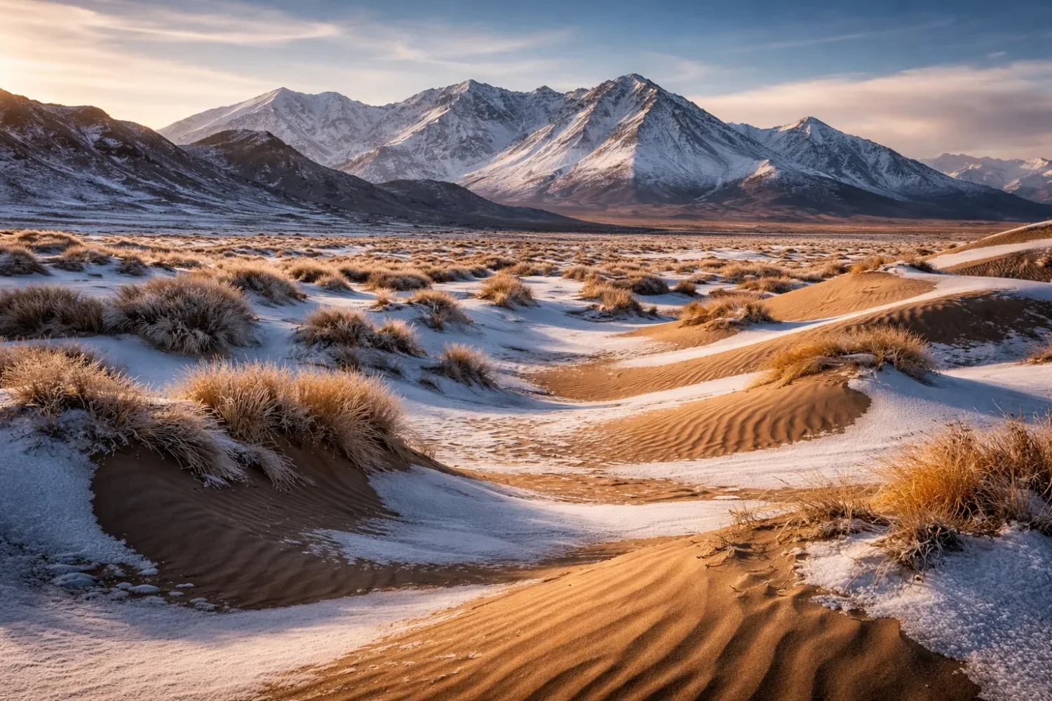
The second missed point is that snow and desert are not opposites. In places like the Gobi, Great Basin, Gurbantünggüt, and Katpana, snow can fall or even linger seasonally while the annual water budget remains deeply negative. Snow is weather. Desert is water balance.
The third missed point is scale. A cold desert is rarely one single surface type. It is usually a regional system of basin floors, mountain fronts, alluvial aprons, dune belts, temporary lakes, saline flats, gravel pavements, and scattered ecological refuges. Reduce it to one postcard image and the real landscape slips away.
That is why the world’s cold arid regions deserve to be read as more than lists of names. They form a connected physical geography of rain shadows, continental cold, short water pulses, wind-shaped sediment, and remarkable restraint in the use of moisture. Few environments make the meaning of dryness so clear. Fewer still wear winter on their surface and remain desert all the same.