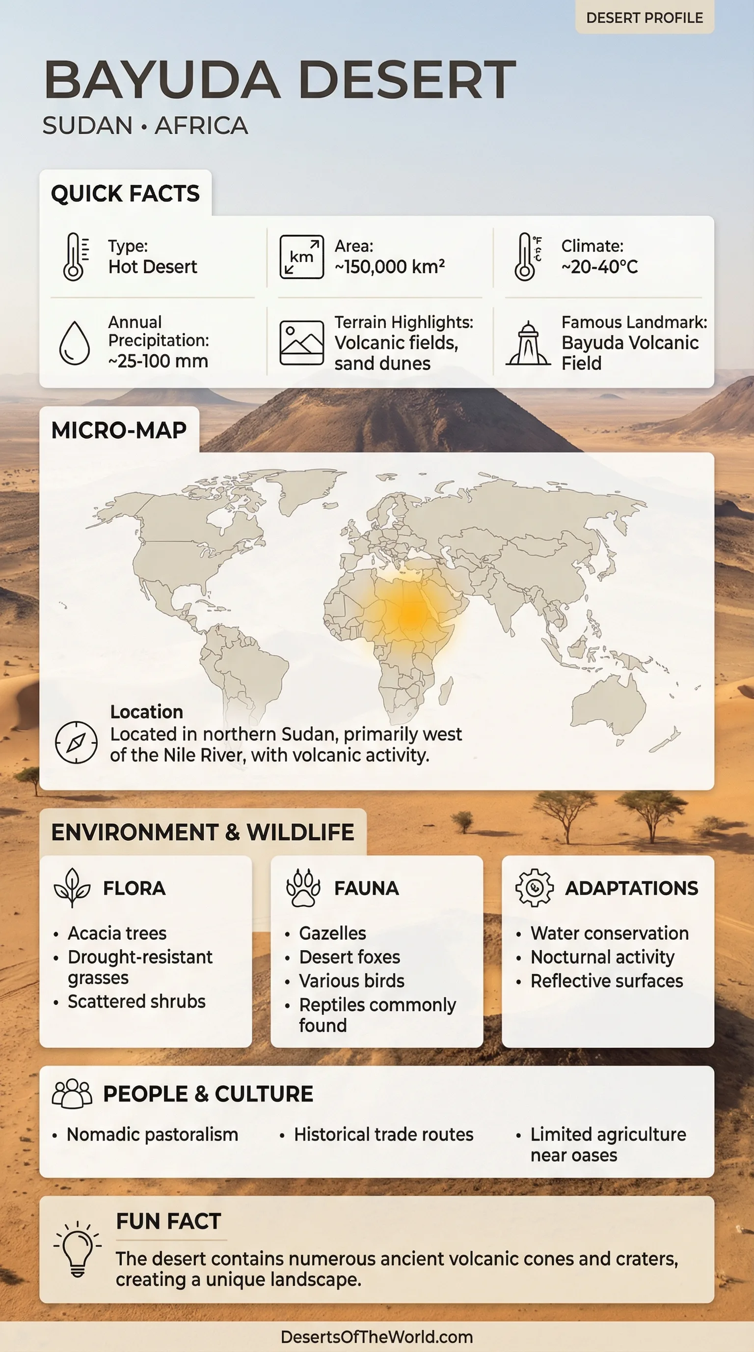
Location & Continent
Continent: Africa
Country: Sudan
Region: Northeastern Sahara / Eastern Sahara
Setting: Inside the Great Bend Of The Nile, with the river looping around the desert’s north, east, and south edges
Coordinates: 18°N, 33°E
Bayuda Desert – Map
Physical Features
Approximate Area: 100,000 km²
Desert Type: Hot Desert with rocky plateaus, sand sheets, and a striking volcanic core
Key Valleys: Wadi Abu Dom (north–south axis) and Wadi Muqqadam (western boundary influence)
Signature Contrast: black basalt beside ochre sands
Ecological Profile
Ecozone: Arid To Hyper-Arid
Typical Vegetation Pattern: Patchy acacia and hardy shrubs in wadis, brief ephemeral greens after rare rains, wide open gravel plains in between
Wildlife Rhythm: Life leans into the cool hours—dawn, dusk, and night—like a quiet clockwork
Introduction To The Bayuda Desert
The Bayuda Desert in Sudan is a desert shaped by a river’s grand loop. The Great Bend Of The Nile wraps around Bayuda like a giant arm, creating a desert that feels both open and oddly enclosed. It is part of the Eastern Sahara, and it carries a rare visual twist: pale sand and sun-bleached rock set beside fields of dark volcanic stone. In a world full of dunes, Bayuda stands out as a desert with a volcanic heartbeat.
Where The Bayuda Desert Sits
The Bayuda Desert lies in northeast Sudan, roughly between the wider Nile corridor near Omdurman to the south and areas closer to Korti farther north. The outline is easy to remember: imagine the Nile drawing a loose horseshoe, and Bayuda resting inside that curve. To the west, the influence of Wadi Muqqadam helps mark the desert’s edge, while the interior is crossed by long, dry channels that look calm most of the year yet still guide water when storms do arrive.
Landscapes That Define Bayuda
Bayuda is not a single texture. It is a mix of surfaces—some smooth, some rough—layered like pages in a book. The western side is often described as sand sheets dotted with rocky outcrops, while the east is known for the Bayuda Volcanic Field. The dividing line is strongly linked to Wadi Abu Dom, a north–south corridor that works like a natural seam running through the desert’s fabric.
- Regs (Gravel Plains): Wind-sorted stones forming firm, open ground with a desert pavement feel.
- Hamadas (Rocky Plateaus): Hard rock surfaces where sunlight seems to bounce upward.
- Sand Sheets: Broad, shallow blankets of sand—less like mountains, more like a golden floor.
- Wadis: Dry channels that can briefly wake up after storms, leaving ribbons of fresh growth.
The Bayuda Volcanic Field
The Bayuda Volcanic Field is the desert’s most distinctive feature, turning parts of the landscape into a dark mosaic. Satellite views show clusters of cones and craters set on older granitic terrain, like black ink spilled across pale paper. Scientific inventories describe dozens of volcanic centers, including many scoria (cinder) cones and a notable number of maar craters. Some lava flows are considered geologically young, adding to the sense that Bayuda is not just an old desert, but a place with a story that continued relatively recently.
| Volcanic Feature | What It Looks Like | Why It Matters |
|---|---|---|
| Scoria Cones | Small, steep hills of dark cinders, often in clusters | Mark eruption points and help map the field’s structure |
| Maar Craters | Broad, bowl-like craters with a sharp rim | Clues to explosive interactions between magma and groundwater |
| Basalt Lava Flows | Dark ribbons of rock, sometimes rough and blocky | Reveal flow direction and preserve surface textures for long periods |
Climate In A River-Bound Desert
The Bayuda Desert is a hot, extremely dry environment where rainfall is scarce and often unpredictable. Many months pass with no measurable rain at all, and when rain does arrive it can be brief, localized, and fast-moving. Heat is strongest in late spring and early summer, while winter brings milder days and cooler nights. Wind plays an everyday role, polishing rock, moving fine sand, and softening sharp edges over time—slow work, done patiently.
| Season | Typical Feel | Landscape Notes |
|---|---|---|
| Cool Season | Warm days, cooler nights | Crisp air makes rock textures and basalt contrasts stand out |
| Hot Season | Very hot afternoons, strong sun | Sand becomes more mobile; haze can soften distant hills |
| Occasional Storm Windows | Short-lived rain events | Wadis may briefly carry water and spark small bursts of green |
Water, Wadis, And The Quiet Geometry Of Flow
In the Bayuda Desert, water is mostly hidden—stored underground, held in soils, or moving only for a short time through channels. The key idea is not lakes or permanent streams, but pathways. Valleys such as Wadi Abu Dom act like long gutters across a stone roof, collecting rainfall from higher ground and guiding it toward the Nile when conditions line up. This is why some wadi corridors support scattered trees and shrubs: even small, brief pulses of moisture can tip the balance in a place this dry.
Plants That Treat Rain Like A Rare Visitor
Vegetation in the Bayuda Desert is often sparse, yet never random. Plant life gathers where the land offers help: in wadi beds, along shallow depressions, and near occasional water points. Acacia trees are a classic presence, their canopies small and efficient, built to shade their own roots. After a rare rainfall, short-lived grasses and tiny flowering plants may appear, then fade again—like a quick note written in green ink across the desert floor.
- Wadi Vegetation: acacia, shrubs, and seasonal ground cover.
- Rocky Slopes: hardy, slow-growing plants that hold on in cracks and pockets of soil.
- Sand Sheets: fewer plants, often only where moisture lingers slightly longer beneath the surface.
Wildlife Adapted To Heat And Open Space
Animals in the Bayuda Desert are specialists in timing and efficiency. Many are most active when the air cools—early morning and evening—then rest during the hottest hours. Small reptiles and insects often thrive in the warm ground, while birds use the desert as a vast aerial corridor. Larger mammals can be present too, especially near wadis or areas with more consistent vegetation. The pattern is simple: energy is saved, movement is purposeful, and water is treated like a precious tool rather than a constant supply.
Stone, Time, And Human Traces
Bayuda’s open landscapes have preserved traces of long human presence, especially along routes where wadis offer water and shelter. Archaeological research in the region has documented sites from very early periods through later eras, often tied to movement between the Nile and interior valleys. In a desert, even a low ridge or a sheltered wadi bend can become a landmark, and across centuries those landmarks can gather stories. The desert does not hold noise for long, yet it holds patterns—paths, camps, and remnants—sometimes for a very long time, and teh result is a landscape that reads like a quiet archive.
Why Bayuda Feels Different From Many Deserts
Many deserts are introduced through dunes. Bayuda can be introduced through contrast. The Great Bend Of The Nile gives it a rare frame, and the Bayuda Volcanic Field gives it a rare palette. Pale sands, light granite, and black basalt share the same horizon. Wadis carve gentle lines across the surface, and small pockets of vegetation appear where the land briefly gathers moisture. It is a desert of structure, where geology, climate, and drainage fit together like interlocking pieces.
Sources
Smithsonian Institution – Global Volcanism Program: Bayuda Volcanic Field
University Of Pretoria Repository – Bayuda Monogenetic Volcanic Field (PDF)
W.A.D.I. Project – Wadi Abu Dom And Bayuda Context
Heidelberg University Library (PropylaeumDOK) – Western Bayuda / Wadi Abu Dom Itinerary (PDF)
Cambridge Core (Antiquity) – Prehistoric Communities In The Bayuda Desert