Location & Continent
Continent: Asia
Region: Arabian Peninsula
Country: United Arab Emirates
Emirate: Abu Dhabi
Nearby Cities: Abu Dhabi, Al Ain
Core Coordinates: 24.2°N, 54.8333°E
Al Khatim Desert – Map Views
Photos of the Al Khatim Desert
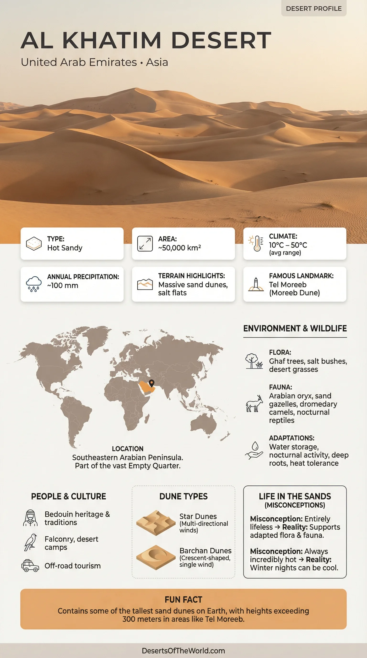
Physical Features
Landscape Type: Dune fields over arid plains
Signature Forms: crescent dunes, long ridges, and interdune corridors
Surface Mix: fine sand plus patches of firmer, crusted ground
Setting: A desert belt between Abu Dhabi and Al Ain, close to the E22 corridor
Climate & Rainfall Pattern
Climate Type: Hot desert with very low rainfall
Heat Rhythm: very hot summers, milder winters, and cooler nights
Rainfall: infrequent and often short-lived, with most wetter spells in cooler months
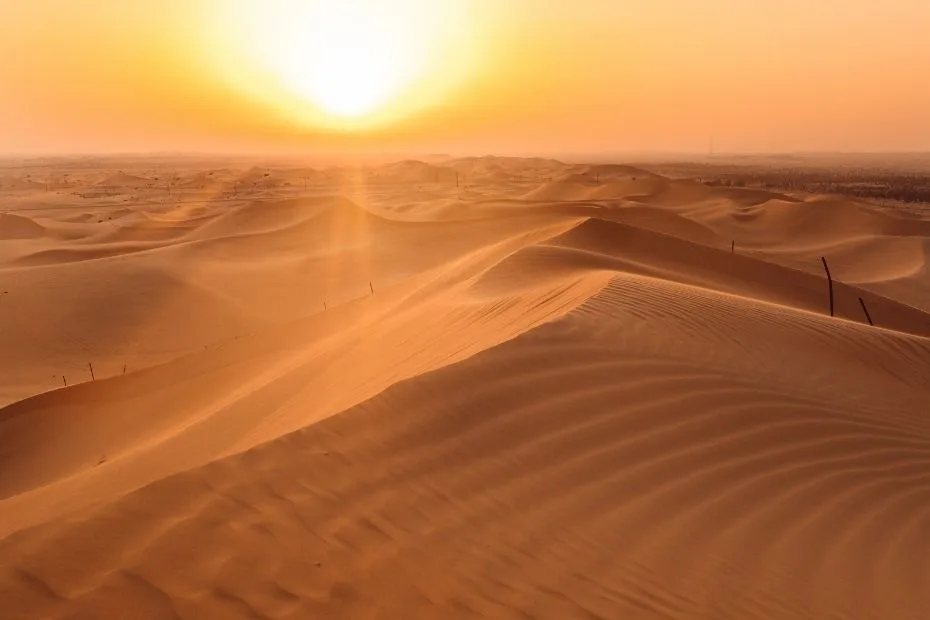
Winds: Seasonal breezes can sculpt dunes like slow-motion waves; dust and sand may travel far on windy days
Ecological Setting
Biome: Deserts and xeric shrublands
Key Idea: Life clusters where shade, firm ground, or hidden moisture offer small advantages
Common Vegetation Style: deep-rooted trees, salt-tolerant shrubs, and quick-blooming annuals after rare rain
Flora & Fauna
The most recognizable plant of the wider Abu Dhabi desert is the Ghaf tree (Prosopis cineraria), a living umbrella in a place with little shade.
Its presence can turn an empty-looking patch of sand into a small neighborhood of life, with cooler soil and windbreak effects.
- Plants: Ghaf, hardy desert shrubs, salt-tolerant plants near crusty flats, and ephemeral flowers after rain
- Animals: small desert mammals, reptiles that use burrows, and birds that track insects and seeds
- Daily Timing: many creatures stay quiet in daytime heat, then become active in the cooler hours
Geology & Landform Story
Al Khatim Desert sits in a zone where two big processes meet: wind-built dunes and alluvial plains shaped by water long ago and, in subtle ways, still today.
It’s not a contradiction. In deserts, water often works like a quiet editor, changing the page when no one is watching.
One reason the ground can vary so sharply is the influence of the Hajar Mountains to the east.
Sediment washed from mountain fronts forms alluvial surfaces, and some natural pathways can guide subsurface runoff across the lowlands.
That hidden movement helps explain why certain corridors feel firmer, and why scattered vegetation can appear where you least expect it.
In lower, flatter pockets, salts can concentrate and create sabkha-like crusts.
These surfaces may look smooth from a distance, almost like frozen lakes, yet they’re part of the same desert system that grows dunes nearby.
On a calm morning, teh contrast is striking.
Introduction to the Al Khatim Desert
The Al Khatim Desert is a broad belt of sand and open desert terrain between Abu Dhabi and Al Ain.
It’s known for clean dune lines, wide horizons, and a sense of space that feels almost architectural.
Think of the dunes as ocean swells that decided to stop moving—until the wind returns and redraws the edges.
Because it lies close to major roads, the area is often used for desert driving and guided outings, yet much of the landscape remains visually undeveloped.
That combination—easy access and open desert character—makes it a useful reference point for understanding how the UAE’s inland deserts are put together.
Where It Fits in the Arabian Desert
The UAE is part of the wider Arabian Desert, and its inland sands connect to larger dune regions across the peninsula.
Some writers describe Al Khatim as lying near the northern edge of the broader Empty Quarter context, where sand seas and interdune flats dominate farther south.
The exact boundary isn’t a fence line; it’s more like a color gradient between dune styles and ground textures.
What matters on the ground is the pattern: dunes align with prevailing winds, while corridors and flats often track older surfaces beneath.
In satellite views, this reads like a stitched fabric—threads of sand laid over a base of plains and crusts.
Dunes, Corridors, and Firm Ground
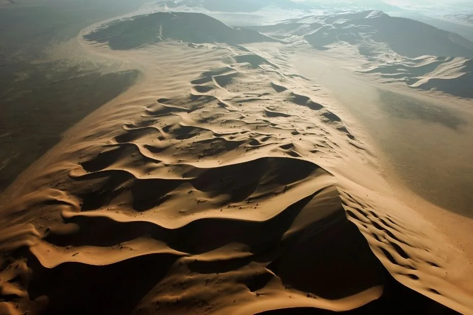
The most visible features are the dunes: long ridges and crescent forms that catch light at sunrise and sunset with sharp shadow lines.
Between them lie interdune corridors—flatter passages that can be sand-filled, gravelly, or lightly crusted depending on sediment and moisture history.
This mix creates a desert with texture.
One moment it’s soft, flowing sand, the next it’s a firmer patch that feels like a natural floor.
Those shifts aren’t random; they often reflect changes in grain size, salt content, and how wind sorts the surface.
How Water Still Leaves Its Signature
Even in a place defined by dryness, water pathways shape the story.
The nearby mountains and their foothills feed alluvial plains, and some valleys can guide underground flow across the landscape.
It’s a subtle process, but it helps explain why vegetation sometimes appears as scattered punctuation across the sand.
After rare rain, shallow sheets of water may briefly move across flats and low spots.
The surface can dry fast, yet the aftereffects remain: thin crusts, redistributed silt, and a short window where annual plants can sprout.
It’s like a desert version of spring—fast, bright, and gone.
Plants Built for Heat and Patience
Desert plants here succeed by being stingy with water and smart with timing.
Leaves may be small, waxy, or absent; roots may reach deep; growth may pause for long stretches.
When conditions align, the response can be sudden—green flecks on sand that looked completely bare the day before.
The Ghaf tree stands out because it creates micro-shade and calmer air near the ground.
Under a mature ghaf, the desert feels a little less harsh, almost like stepping under a thin roof.
That small comfort can support insects, birds, and other life that relies on cooler pockets.
Wildlife and Quiet Adaptations
Much of the desert’s wildlife is easy to miss.
Many animals avoid the hottest hours, using burrows, shade, or nighttime activity to stay within safe temperatures.
Tracks on a smooth dune face can be more revealing than a direct sighting—tiny signatures that prove the sand is never truly empty.
Reptiles often rely on sun-warmed surfaces in cooler hours, then retreat when heat peaks.
Birds may appear around shrubs and trees, especially where seeds and insects are available.
The overall pattern is simple: energy conservation, shade seeking, and using the landscape like a map of opportunities.
Landforms
| Landform | What It Looks Like | Why It Matters |
|---|---|---|
| Crescent Dunes | Curved ridges with a steeper lee side | Showcases wind direction and sand supply |
| Long Dune Ridges | Parallel or gently winding lines across open terrain | Marks persistent winds and dune-field organization |
| Interdune Corridors | Flatter passages between dunes | Often guide movement of water, sediment, and life |
| Crusted Flats | Smooth areas that can look like dried surfaces | Hints at salts and changing moisture conditions |
| Vegetation Patches | Scattered shrubs or single trees | Signals microhabitats and slightly better resources |
Why the Al Khatim Landscape Feels Distinct
The appeal of Al Khatim Desert is its clarity: dunes that read like clean brushstrokes, open flats that make distance feel honest, and a setting that connects city edges to true desert form.
It also reflects a wider UAE pattern described in official ecosystem overviews—sand dunes, oases, valleys, and salt plains forming a patchwork across the country.
For anyone building a mental map of deserts, this is a good place to learn the language of sand: how wind writes ridges, how low spots collect salts, and how a single Ghaf can make the difference between “empty” and “alive.”
Sources
Al Khatim Desert (Overview and Coordinates)
UAE Government Platform: Topography and Ecosystems
Environment Agency – Abu Dhabi: Ghaf Tree
Environmental Atlas of Abu Dhabi Emirate: Dunes and Sabkha
NASA Earth Observatory: Ar Rub’ al Khali Sand Sea
UNESCO World Heritage Centre: Abu Dhabi Sabkha (Tentative Listing)
University of Oxford ORA: Research on Alluvial Fans in the Hajar Region